
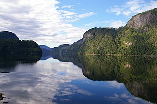
Lysefjord or Lysefjorden is a fjord located in the Ryfylke area in southwestern Norway. The 42-kilometre (26 mi) long fjord lies in Forsand municipality in Rogaland county, about 25 kilometres (16 mi) east of the city of Stavanger. The name means light fjord, and is said to be derived from the lightly coloured granite rocks along its sides. It is particularly well known by the huge Preikestolen cliff overlooking the fjord, which is a major tourist destination for the region. The fairly isolated village of Lysebotn lies at the eastern end of the fjord and the villages of Forsand and Oanes both lie at the western end of the fjord near the Lysefjord Bridge, the only crossing of the fjord.

The Hardangerfjord is the fourth longest fjord in the world, and the second longest fjord in Norway. It is located in Hordaland county in the Hardanger region. The fjord stretches 179 kilometres (111 mi) from the Atlantic Ocean into the mountainous interior of Norway along the Hardangervidda plateau. The innermost point of the fjord reaches the town of Odda.

Jøssingfjorden is a fjord in Sokndal municipality in Rogaland county, Norway. The 3-kilometre (1.9 mi) long fjord is narrow and deep and is surrounded by mountains. It sits about 4 kilometres (2.5 mi) southeast of the municipal centre of Hauge. There is some settlement on the southeastern side of the fjord: the villages of Li, Vinterstø, and Bu. There is a road that runs along the southeast coast of the fjord, with sharp hairpin turns leading down from the mountains to the shore of the fjord both heading north and south from the fjord.

Glomfjord is a village in the municipality of Meløy in Nordland county, Norway. The industrial community is located along Norwegian County Road 17 at the head of the Glomfjorden, just north of the Arctic Circle. The 1.14-square-kilometre (280-acre) village has a population (2018) of 1,077 and a population density of 945 inhabitants per square kilometre (2,450/sq mi).

The Nærøyfjord is a fjord in the municipality of Aurland in Sogn og Fjordane, Norway. The narrow fjord is a branch of the large Sognefjord, and it is featured on the "Norway in a Nutshell" daytrips for tourists. The 18-kilometre (11 mi) long fjord is only 500 metres (1,600 ft) wide in some parts.

Sandane is the administrative centre of the municipality of Gloppen in Sogn og Fjordane county, Norway. It is located at the end of the Gloppefjorden, along the European route E39 highway. Sandane is 20 kilometres (12 mi) south of the village of Nordfjordeid and about 16 kilometres (9.9 mi) west of the village of Byrkjelo. Sandane Airport, Anda is located 10 kilometres (6.2 mi) northwest of Sandane along highway E39. Sandane has several suburban areas that surround the nearby fjord such as Sørstranda to the west and Vereide to the northwest.

Kilsfjorden is a fjord in Volda Municipality in Møre og Romsdal county, Norway. It is located along the European route E39 highway in the central part of the municipality, about 6 kilometres (3.7 mi) east of the Dalsfjorden. The Kilsfjorden is located in the Sunnmørsalpene mountains and it flows north and joins the Austefjorden to form the Voldsfjorden. The village of Straumshamn lies on the southwestern coast of the fjord, at the entrance to the Kilspollen, a nearly 3-kilometre (1.9 mi) long inlet that comes off of the Kilsfjorden.

Jølstravatnet or Jølstravatn is a lake in the municipality of Jølster in Sogn og Fjordane county, Norway. The lake empties its water into the 20-kilometre (12 mi) long Jølstra river which then flows into the Førdefjorden. The impressive eastern arm of Jølstravatn is called Kjøsnesfjorden, although it is not a true fjord that is part of the sea. The villages of Skei, Helgheim, Ålhus, and Vassenden are located on the shores of the lake.
Osterfjorden is a fjord in Hordaland county, Norway. The fjord is one of three fjords surrounding the island of Osterøy. The fjord runs along the municipal border of Lindås and Osterøy municipalities. The fjord begins at the Romarheimsfjorden and flows to the west for 27 kilometres (17 mi) before ending near the village of Knarvik at the confluence of four fjords: Osterfjorden, Radfjorden, Sørfjorden, and Salhusfjorden. The Osterfjorden is generally about 1 to 3 kilometres wide and the deepest point in the fjord reaches a depth of 639 metres (2,096 ft) below sea level.

Mesøya or Mesøy is an island in the municipality of Meløy in Nordland county, Norway. The island is located just southwest of the village of Ørnes on the mainland and east of the island of Meløya. The island sits at the mouth of the Glomfjorden. Mesøya is only accessible by boat, and it has no regular ferry service. Mesøya has an area of 8 square kilometres (3.1 sq mi) and the highest point on the island is the 364-metre (1,194 ft) tall Mesøytoppen.

The Stjørnfjord or Stjørnfjorden is an arm of Trondheimsfjorden that flows through the municipalities of Bjugn, Ørland, and Indre Fosen in Trøndelag county, Norway. The 20-kilometre (12 mi) long fjord stretches southwest from the mouth of the Nordelva river near the village of Råkvåg to the Trondheimsfjord near Brekstad and Austrått. The inner part of the fjord splits into two smaller arms, the Nordfjord and Sørfjord. The Bjugnfjorden lies about 6 kilometres (3.7 mi) north of the fjord.

Aurlandsfjord is a fjord in Sogn og Fjordane county, Norway. The fjord flows through the municipalities of Aurland, Vik, and Lærdal. The 29-kilometre (18 mi) long fjord is a branch off of the main Sognefjorden, Norway's longest fjord. The fjord is deep and narrow, reaching a depth of about 962 metres (3,156 ft) below sea level, and its width is generally less than 2 kilometres (1.2 mi) wide. About 11 kilometers (6.8 mi) south of the mouth of the fjord, the Nærøyfjord branches off from it to the west. The village of Flåm sits at the innermost part of the Aurlandsfjord; other villages along the fjord are Aurlandsvangen and Undredal. Most of the fjord is surrounded by up to 1,800-metre (5,900 ft) tall, steep mountains with little habitation along the fjord except for in a few small valleys.
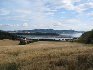
Beitstadfjorden is the innermost arm of the Trondheimsfjord in Trøndelag county, Norway. It is located in the municipalities of Steinkjer, Inderøy, and Verran. The fjord has a length of 28 kilometres (17 mi) from southwest to northeast, and a width of about 6 to 8 kilometres.

Gratangen (Northern Sami) or Rivtták (Northern Sami) is a fjord in Gratangen Municipality in Troms county, Norway. The 23-kilometre (14 mi) long fjord is an arm off of the main Astafjorden. The municipality of Gratangen surrounds the fjord and is named after the fjord. The fjord is about 1 to 2 kilometres wide, except for a very narrow 350-metre (1,150 ft) wide point in the middle of the fjord where the village of Årstein is located. At that point, the Årstein Bridge on Norwegian County Road 825 crosses the fjord.
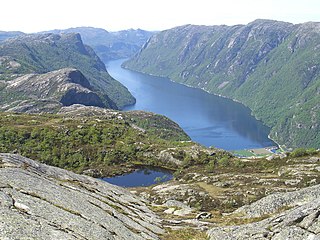
Frafjorden is a fjord in the municipalities Gjesdal and Forsand in Rogaland county, Norway. The 6-kilometre (3.7 mi) fjord is the innermost branch of the Høgsfjorden. The Frafjorden has steep sides with no habitation along its shores, except for the village of Frafjord at the innermost part of the fjord. The village and the surrounding Frafjorddalen farming valley stretches about 5 kilometres (3.1 mi) east of the fjord and the whole area has about 100 residents. There are also many holiday cottages on top of the high mountain located south of the village of Frafjord. The village of Dirdal is located at the mouth of the Frafjorden.

Ørstafjorden is a fjord in Ørsta Municipality in Møre og Romsdal county, Norway. The 10-kilometre (6.2 mi) long fjord runs from the village of Ørsta to the Vartdalsfjorden. The fjord is about 2 kilometres (1.2 mi) wide and the deepest point in the fjord reaches 172 metres (564 ft) below sea level. The European route E39 highway runs along the eastern and southern shores of the fjord. The southern entrance to the Eiksund Tunnel is located along the western shore of the fjord. The inner parts of the fjord do freeze when there are extended periods of cold weather in the winters.

Forsand is the administrative centre of Forsand Municipality in Rogaland county, Norway. The village is located along the Høgsfjorden, at the mouth of the 42-kilometre (26 mi) long Lysefjorden, on the southern side of the fjord. The Lysefjord Bridge is located just northeast of Forsand village and it crosses the Lysefjorden, connecting it to the small village of Oanes which sits on the north side of the fjord. The village of Høle is located across the Høgsfjorden to the west. Høle is connected to Forsand-Oanes by a regular ferry connection.

Gloppefjorden or Gloppenfjorden is a fjord in Gloppen Municipality in Sogn og Fjordane county, Norway. The 12-kilometre (7.5 mi) long fjord flows from the village of Sandane in the southeast to its mouth at the Nordfjorden in the northwest. The river Gloppeelva is the primary inflow on the fjord. The river comes from the large lake Breimsvatnet. The 2.7-kilometre (1.7 mi) wide fjord has a lot of settlements along the inner parts of the fjord, especially on the eastern side of the fjord. The most notable village areas are Sandane, Vereide, and Sørstranda. The European route E39 highway runs along the eastern side of the fjord. Sandane Airport, Anda is located near the mouth of the fjord.

Bruvik is a village in Osterøy municipality in Hordaland county, Norway. The village is located on the southern shore of the island of Osterøy, along the Sørfjorden. It sits about 13 kilometres (8.1 mi) east of the village of Hausvik and about 3 kilometres (1.9 mi) across the fjord from the village of Vaksdal.

Eidfjord is the administrative centre of Eidfjord municipality in Hordaland county, Norway. The village is located on the shore of the Eid Fjord, an inner branch of the large Hardangerfjorden. The village sits about 15 kilometres (9.3 mi) east of the Hardanger Bridge along the Norwegian National Road 7.


