
The Euphrates is the longest and one of the most historically important rivers of Western Asia. Together with the Tigris, it is one of the two defining rivers of Mesopotamia. Originating in Turkey, the Euphrates flows through Syria and Iraq to join the Tigris in the Shatt al-Arab in Iraq, which empties into the Persian Gulf.

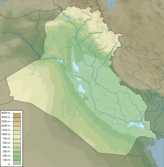
The geography of Iraq is diverse and falls into five main regions: the desert, Upper Mesopotamia, the northern highlands of Iraq, Lower Mesopotamia, and the alluvial plain extending from around Tikrit to the Persian Gulf.
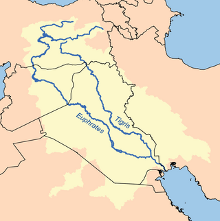
The Tigris is the eastern of the two great rivers that define Mesopotamia, the other being the Euphrates. The river flows south from the mountains of the Armenian Highlands through the Syrian and Arabian Deserts, and empties into the Persian Gulf.

The Shatt al-Arab is a river about 200 kilometres (120 mi) in length that is formed at the confluence of the Euphrates and Tigris rivers in the town of al-Qurnah in the Basra Governorate of southern Iraq. The southern end of the river constitutes the Iran–Iraq border down to its mouth, where it discharges into the Persian Gulf. The Shatt al-Arab varies in width from about 232 metres (761 ft) at Basra to 800 metres (2,600 ft) at its mouth. It is thought that the waterway formed relatively recently in geological time, with the Tigris and Euphrates originally emptying into the Persian Gulf via a channel further to the west. Kuwait's Bubiyan Island is part of the Shatt al-Arab delta.
The Tigris–Euphrates river system is a large river system in Western Asia that discharges into the Persian Gulf. Its principal rivers are the Tigris and Euphrates, along with smaller tributaries.

The Marsh Arabs, also referred to as Ahwaris, the Maʻdān or Shroog —the latter two often considered derogatory in the present day—are Arabian inhabitants of the Mesopotamian marshlands in the modern-day south Iraq, as well as in the Hawizeh Marshes straddling the Iraq-Iran border.

Lake Tharthar, and known in Iraq as Buhayrat ath-Tharthar, is an artificial lake created in 1956, situated 100 kilometers northwest of Baghdad between the Tigris and the Euphrates rivers.

Amarah, also spelled Amara, is a city in south-eastern Iraq, located on a low ridge next to the Tigris River waterway south of Baghdad about 50 km from the border with Iran. It lies at the northern tip of the marshlands between the Tigris and Euphrates.
The wildlife of Iraq includes its flora and fauna and their natural habitats. Iraq has multiple biomes from mountainous region in the north to the wet marshlands along the Euphrates river. The western part of the country is mainly desert and some semi-arid regions. As of 2001, seven of Iraq's mammal species and 12 of its bird species were endangered. The endangered species include the northern bald ibis and Persian fallow deer. The Syrian wild ass is extinct, and the Saudi Arabian dorcas gazelle was declared extinct in 2008.

The Mesopotamian Marshes, also known as the Iraqi Marshes, are a wetland area located in Southern Iraq and southwestern Iran as well as partially in northern Kuwait. The marshes are primarily located on the floodplains of the Euphrates and Tigris rivers bound by the cities of Basra, Nasiriyah, Amarah and a portion of southwestern Iran and northern Kuwait. Historically the marshlands, mainly composed of the separate but adjacent Central, Hawizeh and Hammar Marshes, used to be the largest wetland ecosystem of Western Eurasia. The unique wetland landscape is home to the Marsh people, who have developed a unique culture tightly coupled to the landscape – harvesting reeds and rice, fishing and herding water buffalo.

Operation Badr was an Iranian operation conducted during the Iran–Iraq War against the forces of Ba'athist Iraq. The Iranians launched their offensive on March 11 and succeeded in capturing a part of the Basra-Amarah-Baghdad highway. The following Iraqi counterattack, however, forced the Iranians out in a continual war of endless stalemate.
Al-Qurnah is a town in southern Iraq about 74 km northwest of Basra, that lies within the conglomeration of Nahairat. Qurna is located at the confluence point of the Tigris and Euphrates rivers to form the Shatt al-Arab waterway. Local folklore holds Qurnah to have been the original site of biblical paradise, the Garden of Eden, and location of the Tree of Knowledge.

The Mesopotamian Marshes were drained in Iraq and to a smaller degree in Iran between the 1950s and 1990s to clear large areas of the marshes in the Tigris-Euphrates river system. The marshes formerly covered an area of around 20,000 km2 (7,700 sq mi). The main sub-marshes, the Hawizeh, Central, and Hammar marshes, were drained at different times for different reasons.
The Hammar Marshes are a large wetland complex in southeastern Iraq that are part of the Mesopotamian Marshes in the Tigris–Euphrates river system. Historically, the Hammar Marshes extended up to 4,500 km2 (1,700 sq mi) during seasonal floods. They were destroyed during the 1990s by large-scale drainage, dam and dike construction projects. Since 2003, they are recovering following reflooding and destruction of dams.
The Hawizeh Marshes are a complex of marshes that straddle the Iran–Iraq border. The marshes are fed by two branches of the Tigris River in Iraq and the Karkheh River in Iran. The Hawizeh marsh is critical to the survival of the Central and Hammar marshes also make up the Mesopotamian Marshes, because they are a refuge for species that may recolonize or reproduce in other marshlands. Hawizeh Marshes are drained by the Al-Kassarah. This river plays a critical role in maintaining the marshes as a flow-through system and preventing it from becoming a closed saline basin.
The Central or Qurna Marshes are a large complex of wetlands in Iraq that, along with the Hawizeh and Hammar marshes, make up the Mesopotamian Marshes of the Tigris–Euphrates river system. Formerly covering an area of around 3000 square kilometres, they were almost completely drained following the 1991 uprisings in Iraq and have in recent years been reflooded.

Al-Hindiya District is a district of the Karbala Governorate, Iraq. Its largest town is Al-Hindiya, to the east of Karbala. The Hindiya Barrage in the north of the district controls floods and diverts water from the Euphrates into irrigation canals on both sides of the river. The district has been the scene of clashes with Turkish and British colonial forces, and more recently with American troops in 2003. The population is about 230,000, mostly Shia, including significant numbers of refugees. Infrastructure is poor, but efforts are being made to improve it.
In Iraq, climate change has led to environmental impacts such as increasing temperatures, decreasing precipitation, land degradation, and water scarcity. Climate change poses numerous risks to human health, livelihoods, political stability, and the sustainable development of the nation. The combination of ecological factors, conflict, weak governance, and an impeded capacity to mitigate climate change, has made Iraq uniquely at risk to the negative effects of climate change, with the UN ranking them the 5th most vulnerable country to climate change. Rising temperatures, intensified droughts, declining precipitation, desertification, salinization, and the increasing prevalence of dust storms are challenges Iraq faces due in to the negative impacts of climate change. National and regional political instability and conflict have made it difficult to mitigate the effects of climate change, address transnational water management, and develop sustainably. Climate change has negatively impacted Iraq's population through loss of economic opportunity, food insecurity, water scarcity, and displacement.

