
Fåberg is a village and former municipality in Oppland county, Norway.

Chochkan is a village in the Lori Province of Armenia.
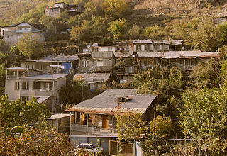
Kizilshafak, is an abandoned village in the Lori Province of Armenia.

Kiełbasin is a village in the administrative district of Gmina Chełmża, within Toruń County, Kuyavian-Pomeranian Voivodeship, in north-central Poland. It lies approximately 10 kilometres (6 mi) east of Chełmża and 17 km (11 mi) north-east of Toruń.
Avan is a village in the Aragatsotn Province of Armenia. The population of the village is mainly Armenian. It is home to the basilica-style church of Surb Astvatsatsin that sits along a street just off the main road beside the main cemetery. The large cemetery contains many khachkars from the 13th to 18th centuries. Adjacent to it across the street is a stepped plinth and broken funerary pillar monument of the 5th to 6th centuries. A worn inscription may be found along the landings of the second and third steps. There is a newly built church also by the name of Surb Astvatsatsin that sits near the main highway closer to the centre of the village, and is said to have been constructed upon old foundations. Some confusion may arise since two churches in the village are referred to as S. Astvatsatsin, but one of them may be the church of S. Hovhannes. They are said to have been first built in the 5th to 6th centuries, were reconstructed in the 13th century, and have sat in ruins until recently since the earthquake of 1679.

Keşxurt is a village in the Ismailli Rayon of Azerbaijan. The village forms part of the municipality of Gəraybəyli.
Qazançı is a village in the Zangilan Rayon of Azerbaijan.
Kolayır is a village in the Agstafa Rayon of Azerbaijan. The village forms part of the municipality of Düzqışlaq.

Szadkowice is a village in the administrative district of Gmina Sławno, within Opoczno County, Łódź Voivodeship, in central Poland. It lies approximately 4 kilometres (2 mi) north-east of Sławno, 10 km (6 mi) north-west of Opoczno, and 63 km (39 mi) south-east of the regional capital Łódź.
Stara Olszówka is a village in the administrative district of Gmina Wodzisław, within Jędrzejów County, Świętokrzyskie Voivodeship, in south-central Poland. It lies approximately 2 kilometres (1 mi) south-west of Wodzisław, 17 km (11 mi) south-west of Jędrzejów, and 52 km (32 mi) south-west of the regional capital Kielce.
Rędocin is a village in the administrative district of Gmina Bliżyn, within Skarżysko County, Świętokrzyskie Voivodeship, in south-central Poland. It lies approximately 8 kilometres (5 mi) north of Bliżyn, 15 km (9 mi) north-west of Skarżysko-Kamienna, and 33 km (21 mi) north of the regional capital Kielce.
Białogród-Kolonia is a village in the administrative district of Gmina Kleczew, within Konin County, Greater Poland Voivodeship, in west-central Poland.
Jaraczewo is a village in the administrative district of Gmina Szydłowo, within Piła County, Greater Poland Voivodeship, in west-central Poland. It lies approximately 2 kilometres (1 mi) north-west of Szydłowo, 10 km (6 mi) west of Piła, and 88 km (55 mi) north of the regional capital Poznań.
Łebieńska Huta is a village in the administrative district of Gmina Szemud, within Wejherowo County, Pomeranian Voivodeship, in northern Poland. It lies approximately 7 kilometres (4 mi) south-west of Szemud, 19 km (12 mi) south of Wejherowo, and 32 km (20 mi) west of the regional capital Gdańsk.
Kolonia Rybacka is a village in the administrative district of Gmina Węgorzewo, within Węgorzewo County, Warmian-Masurian Voivodeship, in northern Poland, close to the border with the Kaliningrad Oblast of Russia.
Barčiai is a village in Varėna district municipality, in Alytus County, in southeastern Lithuania. According to the 2001 census, the village has a population of 182 people.

Negrišori is a village in the municipality of Lučani, Serbia. According to the 2011 census, the village has a population of 499 people.
Kesklahe is a village in Peipsiääre Parish, Tartu County in eastern Estonia.
Dučić is a village situated in Mionica municipality in Serbia.
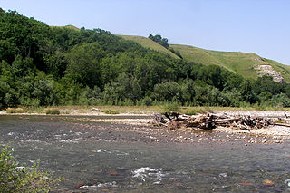
The Urup is a river in the North Caucasus. It is a left tributary of the Kuban River, which it joins at Armavir.


