| Gmina Gołcza Gołcza Commune | |||
|---|---|---|---|
| Gmina | |||
| |||
| Coordinates(Gołcza): 50°20′13″N19°55′39″E / 50.33694°N 19.92750°E Coordinates: 50°20′13″N19°55′39″E / 50.33694°N 19.92750°E | |||
| Country | |||
| Voivodeship | Lesser Poland | ||
| County | Miechów | ||
| Seat | Gołcza | ||
| Area | |||
| • Total | 90.27 km2 (34.85 sq mi) | ||
| Population (2006) | |||
| • Total | 6,265 | ||
| • Density | 69/km2 (180/sq mi) | ||
| Website | http://www.golcza.pl/ | ||


Gmina Gołcza is a rural gmina (administrative district) in Miechów County, Lesser Poland Voivodeship, in southern Poland. Its seat is the village of Gołcza, which lies approximately 8 kilometres (5 mi) west of Miechów and 31 km (19 mi) north of the regional capital Kraków.

The gmina is the principal unit of the administrative division of Poland, similar to a municipality. As of 2010 there were 2,478 gminy throughout the country. The word gmina derives from the German word Gemeinde, meaning "community".
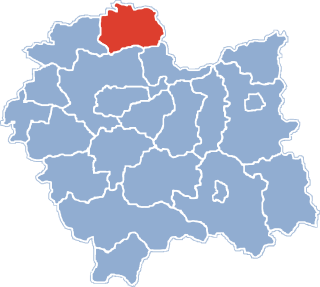
Miechów County is a unit of territorial administration and local government (powiat) in Lesser Poland Voivodeship, southern Poland. It came into being on January 1, 1999, as a result of the Polish local government reforms passed in 1998. Its administrative seat and only town is Miechów, which lies 34 kilometres (21 mi) north of the regional capital Kraków.

Lesser Poland Voivodeship or Lesser Poland Province, also known as Małopolska Voivodeship or Małopolska Province, is a voivodeship (province), in southern Poland. It has an area of 15,108 square kilometres (5,833 sq mi), and a population of 3,267,731 (2006).
Contents
The gmina covers an area of 90.27 square kilometres (34.9 sq mi), and as of 2006 its total population is 6,265.
The gmina contains part of the protected area called Dłubnia Landscape Park.

Protected areas or conservation areas are locations which receive protection because of their recognized natural, ecological or cultural values. There are several kinds of protected areas, which vary by level of protection depending on the enabling laws of each country or the regulations of the international organizations involved.
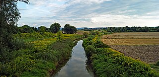
Dłubnia Landscape Park is a protected area in southern Poland, established in 1981, covering an area of 109.37 square kilometres (42.23 sq mi). Within the Landscape Park are two nature reserves.


