Podkarpackie Voivodeship or Podkarpackie Province, also known as Subcarpathian Voivodeship or Subcarpathia Province, is a voivodeship, or province, in extreme-southeastern Poland. Its administrative capital and largest city is Rzeszów..

Łańcut County is a unit of territorial administration and local government (powiat) in Subcarpathian Voivodeship, south-eastern Poland. It came into being on January 1, 1999, as a result of the Polish local government reforms passed in 1998. Its administrative seat and only town is Łańcut, site of the famous Łańcut Castle, lying 17 kilometres (11 mi) east of the regional capital Rzeszów.

Nisko County is a unit of territorial administration and local government (powiat) in Subcarpathian Voivodeship, south-eastern Poland. It came into being on January 1, 1999, as a result of the Polish local government reforms passed in 1998. Its administrative seat and largest town is Nisko, which lies 57 kilometres (35 mi) north of the regional capital Rzeszów. The county also contains the towns of Rudnik nad Sanem, lying 13 km (8 mi) south-east of Nisko, and Ulanów, 11 km (7 mi) east of Nisko.
Przeworsk County is a unit of territorial administration and local government (powiat) in Subcarpathian Voivodeship, south-eastern Poland. It came into being on January 1, 1999, as a result of the Polish local government reforms passed in 1998. Its administrative seat and largest town is Przeworsk, which lies 36 kilometres (22 mi) east of the regional capital Rzeszów. The county also contains the towns of Kańczuga, lying 11 km (7 mi) south-west of Przeworsk, and Sieniawa, 15 km (9 mi) north-east of Przeworsk.

Rzeszów County is a unit of territorial administration and local government (powiat) in Subcarpathian Voivodeship, south-eastern Poland. It came into being on January 1, 1999, as a result of the Polish local government reforms passed in 1998. Its administrative seat is the city of Rzeszów, although the city is not part of the county. The county contains six towns: Dynów, 28 km (17 mi) south-east of Rzeszów, Boguchwała, 8 km (5 mi) south-west of Rzeszów, Głogów Małopolski, 16 km (10 mi) north of Rzeszów, Sokołów Małopolski, 24 km (15 mi) north of Rzeszów, Tyczyn, 8 km (5 mi) south of Rzeszów, and Błażowa, 17 km (11 mi) south-east of Rzeszów.

Biłgoraj County is a unit of territorial administration and local government (powiat) in Lublin Voivodeship, eastern Poland. It was established on January 1, 1999, as a result of the Polish local government reforms passed in 1998. Its administrative seat and largest town is Biłgoraj, which lies 79 kilometres (49 mi) south of the regional capital Lublin. The county contains three other towns: Tarnogród, lying 21 km (13 mi) south of Biłgoraj, Józefów, lying 24 km (15 mi) east of Biłgoraj, and Frampol, 16 km (10 mi) north of Biłgoraj.
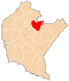
Gmina Kuryłówka is a rural gmina in Leżajsk County, Subcarpathian Voivodeship, in south-eastern Poland. Its seat is the village of Kuryłówka, which lies approximately 5 kilometres (3 mi) northeast of Leżajsk and 44 km (27 mi) north-east of the regional capital Rzeszów.
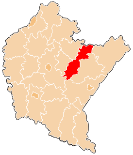
Gmina Nowa Sarzyna is an urban-rural gmina in Leżajsk County, Subcarpathian Voivodeship, in south-eastern Poland. Its seat is the town of Nowa Sarzyna, which lies approximately 11 kilometres (7 mi) north-west of Leżajsk and 40 km (25 mi) north-east of the regional capital Rzeszów.
Gmina Rakszawa is a rural gmina in Łańcut County, Subcarpathian Voivodeship, in south-eastern Poland. Its seat is the village of Rakszawa, which lies approximately 10 kilometres (6 mi) north of Łańcut and 22 km (14 mi) north-east of the regional capital Rzeszów.
Gmina Żołynia is a rural gmina in Łańcut County, Subcarpathian Voivodeship, in south-eastern Poland. Its seat is the village of Żołynia, which lies approximately 15 kilometres (9 mi) north-east of Łańcut and 28 km (17 mi) north-east of the regional capital Rzeszów.
Gmina Sieniawa is an urban-rural gmina in Przeworsk County, Subcarpathian Voivodeship, in south-eastern Poland. Its seat is the town of Sieniawa, which lies approximately 15 kilometres (9 mi) north-east of Przeworsk and 47 km (29 mi) east of the regional capital Rzeszów.
Gmina Tryńcza is a rural gmina in Przeworsk County, Subcarpathian Voivodeship, in south-eastern Poland. Its seat is the village of Tryńcza, which lies approximately 13 kilometres (8 mi) north-east of Przeworsk and 43 km (27 mi) east of the regional capital Rzeszów.
Gmina Sokołów Małopolski is an urban-rural gmina in Rzeszów County, Subcarpathian Voivodeship, in south-eastern Poland. Its seat is the town of Sokołów Małopolski, which lies approximately 24 kilometres (15 mi) north of the regional capital Rzeszów.

Dębno is a village in the administrative district of Gmina Leżajsk, within Leżajsk County, Subcarpathian Voivodeship, in south-eastern Poland. It lies approximately 10 kilometres (6 mi) south-east of Leżajsk and 41 km (25 mi) north-east of the regional capital Rzeszów.
Gwizdów is a village in the administrative district of Gmina Leżajsk, within Leżajsk County, Subcarpathian Voivodeship, in south-eastern Poland. It lies approximately 11 kilometres (7 mi) south-west of Leżajsk and 30 km (19 mi) north-east of the regional capital Rzeszów.