Gmina Łańcut

Last updated
Gmina Łańcut
Łańcut Commune
Gmina
POL gmina Lancut COA.svg
Coat of arms
Coordinates(Łańcut): 50°4′N22°14′E / 50.067°N 22.233°E / 50.067; 22.233 Coordinates: 50°4′N22°14′E / 50.067°N 22.233°E / 50.067; 22.233
CountryFlag of Poland.svg  Poland
Voivodeship Subcarpathian
County Łańcut
Seat Łańcut
Area
  Total 106.65 km2 (41.18 sq mi)
Population (2011 [1] )
  Total 21,108
  Density 200/km2 (510/sq mi)
Website http://www.gminalancut.pl/

Gmina Łańcut (Łańcut Commune) is a rural gmina (administrative district) in Łańcut County, Subcarpathian Voivodeship, in southeastern Poland. Its seat is the town of Łańcut (site of the famous Łańcut Castle), although the town is not part of the territory of the gmina.

Gmina administrative division of Poland

The gmina is the principal unit of the administrative division of Poland, similar to a municipality. As of 2010 there were 2,478 gminy throughout the country. The word gmina derives from the German word Gemeinde, meaning "community".

Łańcut County County in Subcarpathian, Poland

Łańcut County is a unit of territorial administration and local government (powiat) in Subcarpathian Voivodeship, south-eastern Poland. It came into being on January 1, 1999, as a result of the Polish local government reforms passed in 1998. Its administrative seat and only town is Łańcut, site of the famous Łańcut Castle, lying 17 kilometres (11 mi) east of the regional capital Rzeszów.

Poland Republic in Central Europe

Poland, officially the Republic of Poland, is a country located in Central Europe. It is divided into 16 administrative subdivisions, covering an area of 312,696 square kilometres (120,733 sq mi), and has a largely temperate seasonal climate. With a population of approximately 38.5 million people, Poland is the sixth most populous member state of the European Union. Poland's capital and largest metropolis is Warsaw. Other major cities include Kraków, Łódź, Wrocław, Poznań, Gdańsk, and Szczecin.

Contents

The gmina covers an area of 106.65 square kilometres (41.2 sq mi), and as of 2006 its total population is 20,313 (21,108 in 2011).

Neighbouring gminas

Gmina Łańcut is bordered by the town of Łańcut and by the gminas of Białobrzegi, Chmielnik, Czarna, Gać, Krasne, Markowa and Przeworsk.

Gmina Czarna is a rural gmina in Łańcut County, Subcarpathian Voivodeship, in south-eastern Poland. Its seat is the village of Czarna, which lies approximately 7 kilometres (4 mi) north-west of Łańcut and 16 km (10 mi) north-east of the regional capital Rzeszów.

Gmina Gać is a rural gmina in Przeworsk County, Subcarpathian Voivodeship, in south-eastern Poland. Its seat is the village of Gać, which lies approximately 12 kilometres (7 mi) south-west of Przeworsk and 26 km (16 mi) east of the regional capital Rzeszów.

Gmina Markowa is a rural gmina in Łańcut County, Subcarpathian Voivodeship, in south-eastern Poland. Its seat is the village of Markowa, which lies approximately 8 kilometres (5 mi) south-east of Łańcut and 22 km (14 mi) east of the regional capital Rzeszów.

Villages

The gmina contains the following villages: Albigowa, Cierpisz, Głuchów, Handzlówka, Kosina, Kraczkowa, Rogóżno, Sonina and Wysoka.

Albigowa Village in Subcarpathian, Poland

Albigowa is a village in the administrative district of Gmina Łańcut, within Łańcut County, Subcarpathian Voivodeship, in south-eastern Poland. It lies on the Sawa river, approximately 6 kilometres (4 mi) south of Łańcut and 17 km (11 mi) east of the regional capital Rzeszów.

Cierpisz, Łańcut County Village in Subcarpathian, Poland

Cierpisz is a village in the administrative district of Gmina Łańcut, within Łańcut County, Subcarpathian Voivodeship, in south-eastern Poland. It lies approximately 8 kilometres (5 mi) south-west of Łańcut and 12 km (7 mi) east of the regional capital Rzeszów.

Handzlówka Village in Subcarpathian, Poland

Handzlówka is a village in the administrative district of Gmina Łańcut, within Łańcut County, Subcarpathian Voivodeship, in south-eastern Poland. It lies approximately 10 kilometres (6 mi) south of Łańcut and 18 km (11 mi) east of the regional capital Rzeszów.

Related Research Articles

Podkarpackie Voivodeship Voivodeship in Poland

Podkarpackie Voivodeship or Podkarpackie Province, also known as Subcarpathian Voivodeship or Subcarpathia Province, is a voivodeship, or province, in extreme-southeastern Poland. Its administrative capital and largest city is Rzeszów..

Leżajsk County County in Subcarpathian, Poland

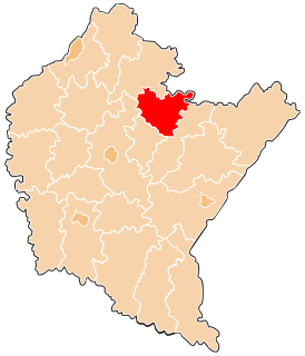
Leżajsk County is a unit of territorial administration and local government (powiat) in Subcarpathian Voivodeship, south-eastern Poland. It came into being on January 1, 1999, as a result of the Polish local government reforms passed in 1998. Its administrative seat and largest town is Leżajsk, which lies 41 kilometres (25 mi) north-east of the regional capital Rzeszów. The only other town in the county is Nowa Sarzyna, lying 11 km (7 mi) north-west of Leżajsk.

Przeworsk County County in Subcarpathian, Poland

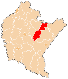
Przeworsk County is a unit of territorial administration and local government (powiat) in Subcarpathian Voivodeship, south-eastern Poland. It came into being on January 1, 1999, as a result of the Polish local government reforms passed in 1998. Its administrative seat and largest town is Przeworsk, which lies 36 kilometres (22 mi) east of the regional capital Rzeszów. The county also contains the towns of Kańczuga, lying 11 km (7 mi) south-west of Przeworsk, and Sieniawa, 15 km (9 mi) north-east of Przeworsk.

Rzeszów County County in Subcarpathian, Poland

Rzeszów County is a unit of territorial administration and local government (powiat) in Subcarpathian Voivodeship, south-eastern Poland. It came into being on January 1, 1999, as a result of the Polish local government reforms passed in 1998. Its administrative seat is the city of Rzeszów, although the city is not part of the county. The county contains six towns: Dynów, 28 km (17 mi) south-east of Rzeszów, Boguchwała, 8 km (5 mi) south-west of Rzeszów, Głogów Małopolski, 16 km (10 mi) north of Rzeszów, Sokołów Małopolski, 24 km (15 mi) north of Rzeszów, Tyczyn, 8 km (5 mi) south of Rzeszów, and Błażowa, 17 km (11 mi) south-east of Rzeszów.

Balmazújváros Town in Hajdú-Bihar, Hungary

Balmazújváros (Bâlmașuivăroș), (Balmazójwarosz),, (Balmašujvaroš), (Bülmajuyvaroş) is a town in Hajdú-Bihar county, in the Northern Great Plain region of eastern Hungary.

Gmina Białobrzegi is a rural gmina in Łańcut County, Subcarpathian Voivodeship, in south-eastern Poland. Its seat is the village of Białobrzegi, which lies approximately 8 kilometres (5 mi) north-east of Łańcut and 24 km (15 mi) east of the regional capital Rzeszów.

Gmina Rakszawa is a rural gmina in Łańcut County, Subcarpathian Voivodeship, in south-eastern Poland. Its seat is the village of Rakszawa, which lies approximately 10 kilometres (6 mi) north of Łańcut and 22 km (14 mi) north-east of the regional capital Rzeszów.

Gmina Żołynia is a rural gmina in Łańcut County, Subcarpathian Voivodeship, in south-eastern Poland. Its seat is the village of Żołynia, which lies approximately 15 kilometres (9 mi) north-east of Łańcut and 28 km (17 mi) north-east of the regional capital Rzeszów.

Gmina Przeworsk is a rural gmina in Przeworsk County, Subcarpathian Voivodeship, in south-eastern Poland. Its seat is the town of Przeworsk, although the town is not part of the territory of the gmina.

Gmina Chmielnik is a rural gmina in Rzeszów County, Subcarpathian Voivodeship, in south-eastern Poland. Its seat is the village of Chmielnik, which lies approximately 13 kilometres (8 mi) south-east of the regional capital Rzeszów.

Gmina Krasne is a rural gmina in Rzeszów County, Subcarpathian Voivodeship, in south-eastern Poland. Its seat is the village of Krasne, which lies approximately 7 kilometres (4 mi) east of the regional capital Rzeszów.

Wola Mała, Lublin Voivodeship Village in Podkarpackie, Poland

Wola Mała is a village in the administrative district of Gmina Łańcut, within Łańcut County, Podkarpacie Voivodeship, in eastern Poland. It lies approximately 3 kilometres (2 mi) east of Biłgoraj and 79 km (49 mi) south of the regional capital Lublin.

Białobrzegi, Podkarpackie Voivodeship Village in Subcarpathian, Poland

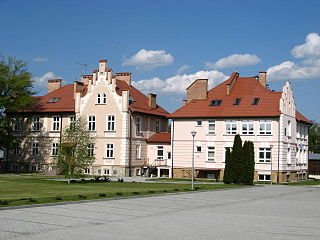
Białobrzegi is a village in Łańcut County, Subcarpathian Voivodeship, in south-eastern Poland. It is the seat of the gmina called Gmina Białobrzegi. It lies approximately 8 kilometres (5 mi) north-east of Łańcut and 24 km (15 mi) east of the regional capital Rzeszów.

Głuchów, Podkarpackie Voivodeship Village in Subcarpathian, Poland

Głuchów is a village in the administrative district of Gmina Łańcut, within Łańcut County, Subcarpathian Voivodeship, in south-eastern Poland. It lies approximately 4 kilometres (2 mi) north-east of Łańcut and 20 km (12 mi) east of the regional capital Rzeszów.

Żołynia Village in Subcarpathian, Poland

Żołynia is a village in Łańcut County, Subcarpathian Voivodeship, in south-eastern Poland. It is the seat of the gmina called Gmina Żołynia. It lies approximately 15 kilometres (9 mi) north-east of Łańcut and 28 km (17 mi) north-east of the regional capital Rzeszów.

References