This article needs additional citations for verification .(April 2021) |

The Golden Mile (German : Goldene Meile) was an Allied POW camp in 1945 on the fertile Rhine plain known as the Golden Mile near Remagen in Germany.
This article needs additional citations for verification .(April 2021) |
The Golden Mile (German : Goldene Meile) was an Allied POW camp in 1945 on the fertile Rhine plain known as the Golden Mile near Remagen in Germany.
Towards the end of the Second World War, US troops established prisoner of war camps along the River Rhine for the detention of German soldiers. During the conquest of the Rhineland 250,000 German soldiers were captured and, following the destruction of the Ruhr Pocket, another 325,000 joined them. From mid-April 1945 around 660,000 Germans [1] were held in these camps. After the collapse of the Western Front, the Americans – themselves suffering from supply shortages – had to accommodate and care for German prisoners of war as well as two million of their own soldiers. The so-called Rheinwiesenlager ("Rhine Pasture Camps") were intended as transit camps, offering temporary accommodation for the prisoners. The Golden Mile was one of these camps.
The camp occupied the area between Remagen and Niederbreisig. On 8 May 1945 it was occupied by 253,000 prisoners. Built for the most part by the prisoners themselves, the camp was surrounded by barbed wire and divided into two separate areas: the first allocated to town of Remagen, the second to the town of Sinzig. Both camp areas were bounded on the east by the Rhine and on the west by the embankment of a railway line.
Inside the camp, individual "cages", separated from one another by barbed wire, held the prisoners in groups of fifty, hundred or a thousand.

The care and housing of prisoners was extremely poor. There were initially neither wooden huts or shelters nor appropriate washing and toilet facilities. Only a few prisoners were allowed to keep a strip of canvas or a coat. The rest were exposed to the hardships of the April weather, with its frequent rain. Some prisoners dug holes in the ground using their hands and primitive tools to seek shelter from the rain. Many died in the temporary dwellings or were buried alive when their burrows collapsed. There was an issue of food once a day. This was initially barely enough to survive. Only after weeks did food for the prisoners improve. Even the drinking water supply was a problem to begin with, and prisoners had to queue for hours to get a little, strongly chlorinated, Rhine water.
On 11 July 1945, the camp was taken over by the French, who finally closed it on 20 July 1945. Many of the prisoners were transferred to other camps or to France and some were not released until one or two years later. During the time that the camp was in existence, 1,247 inmates died of dysentery, undernourishment and exhaustion. In spite of this relatively low death rate of under 1%, many survivors returned from imprisonment traumatized by their experience.

Today, the prisoners are commemorated by the Black Madonna Chapel in Remagen, a monument in Sinzig, the war cemetery in Bad Bodendorf and an exhibition room in the Remagen Bridge Peace Museum. [2]
Ahrweiler is a district in the north of Rhineland-Palatinate, Germany. It is bounded by the districts of Euskirchen, Rhein-Sieg and the city of Bonn in the state of North Rhine-Westphalia, and the districts of Neuwied, Mayen-Koblenz and Vulkaneifel.

The Rheinwiesenlager were a group of 19 concentration camps built in the Allied-occupied part of Germany by the U.S. Army to hold captured German soldiers at the close of the Second World War. Officially named Prisoner of War Temporary Enclosures (PWTE), they held between one and almost two million surrendered Wehrmacht personnel from April until September 1945.

Remagen is a town in Germany in the state of Rhineland-Palatinate, in the district of Ahrweiler. It is about a one-hour drive from Cologne, just south of Bonn, the former West German seat of government. It is situated on the left (western) bank of the river Rhine. There is a ferry across the Rhine from Remagen every 10–15 minutes in the summer. Remagen has many notable and well-maintained buildings, churches, castles and monuments. It also has a sizeable pedestrian zone with plenty of shops.

Bad Neuenahr-Ahrweiler is a spa town in the German Bundesland of Rhineland-Palatinate that serves as the capital of the Ahrweiler district. The A61 motorway connects the town with cities like Cologne and Mainz. Formed by the merging of the towns of Bad Neuenahr and Ahrweiler in 1969, Bad Neuenahr-Ahrweiler consists of 11 such districts.

Ahr is a river in Germany, a left tributary of the Rhine. Its source is at an elevation of approximately 470 metres (1,540 ft) above sea level in Blankenheim in the Eifel, in the cellar of a timber-frame house near the castle of Blankenheim. After 18 kilometres (11 mi) it crosses from North Rhine-Westphalia into Rhineland-Palatinate.

Rhin-et-Moselle was a department of the First French Republic and First French Empire in present-day Germany. It was named after the rivers Rhine and Moselle. It was formed in 1797, when the left bank of the Rhine was annexed by France. Until the French occupation, its territory was divided between the Archbishopric of Cologne, the Archbishopric of Trier, and the Electorate of the Palatinate. Its territory is now part of the German states of Rhineland-Palatinate and North Rhine-Westphalia. Its capital was Koblenz.

The Gardelegen massacre was a massacre perpetrated by the locals of the northern German town of Gardelegen, with direction from the SS, near the end of World War II. On April 13, 1945, on the Isenschnibbe estate near the town, the troops forced over 1,000 slave laborers who were part of a transport train evacuated from the Mittelbau-Dora and Hannover-Stöcken concentration camps into a large barn, which was then set on fire.

Sinzig is a town in the district of Ahrweiler, in Rhineland-Palatinate, Germany. It is situated on the river Rhine, about 5 km south-east of Remagen and 25 km south-east of Bonn, and it has approximately 20,000 inhabitants (2004).
The Amateurliga Rheinland was the highest football league in the region of the Rheinland Football Association and the third tier of the German football league system from its inception in 1952 to the formation of the Oberliga Südwest and the Verbandsliga Rheinland below it in 1978.
The politics of Rhineland-Palatinate takes place within a framework of a federal parliamentary representative democratic republic, where the Federal Government of Germany exercises sovereign rights with certain powers reserved to the states of Germany including Rhineland-Palatinate. The state has a multi-party system where the two main parties are the center-right Christian Democratic Union (CDU) and the center-left Social Democratic Party of Germany (SPD).

The Gau Westphalia-North was an administrative division of Nazi Germany encompassing the Free State of Lippe, the Free State of Schaumburg-Lippe and the northern half of the Prussian province of Westphalia between 1933 and 1945. From 1931 to 1933, it was the regional subdivision of the Nazi Party for these areas.
Bonn-Bad Godesberg station is on the Left Rhine line in the Bonn district of Bad Godesberg in the German state of North Rhine-Westphalia.

The Ahr Valley Railway, Remagen–Ahrbrück, is currently a 29 km-long, partly single-track and non-electrified branch line, which runs through the Ahr valley from Remagen via Ahrweiler and Dernau to Ahrbrück in the German state of Rhineland-Palatinate. It is served by Regionalbahn services on lines RB 30 and RB 39.

The Ahr valley is named after the Ahr, a left tributary of the Rhine in Germany. It begins at the Ahr spring (Ahrquelle) in Blankenheim in the county of Euskirchen and runs generally eastwards. At its southernmost point it enters the county of Ahrweiler, and hence the state of Rhineland-Palatinate. Running through the collective municipality of Adenau the valley bends northeast at its confluence with the Adenauer Bach and reaches the collective municipality of Altenahr, from where it resumes its characteristic west to east course, albeit interrupted by meanders. Here begins the section that is known as the Ahr valley (Ahrtal) in a touristic sense. Here it is characterized by vineyards on the south-facing slopes and a picturesque rocky landscape, carved out by the river creating a 300 metre deep gorge in the Ahr Hills. In the next stage the Ahr reaches the area of the county town of Bad Neuenahr-Ahrweiler, before finally discharging into the Rhine south of Remagen in the borough of Sinzig.
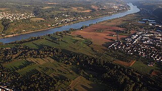
The Golden Mile is the fertile plain lying between Bad Breisig and Remagen to the left of the river Rhine in Germany. The epithet "golden" refers to the fertility of the soil in this area.

The Ahr Cycleway is a cycle path, that runs from the source of the River Ahr in Blankenheim, in the Eifel region of Germany, along the river to its mouth on the Rhine near Kripp. Several sections are on an old railway trackbed. The route starts in the middle of the Eifel mountains and runs initially through a valley landscape with broad river bends. From the hamlet of Schuld the Ahr Valley narrows and swings around the settlement in a loop. In Altenahr, hillsides and rocks come close to the river itself and offer the best conditions for the wine growing. Behind the spa town of Bad Neuenahr-Ahrweiler the Ahr reaches its broad delta on the Rhine. The cycleway is not difficult and suitable for leisure cyclists. The route is uniformly signed with the cycleway's logo.
The Gau Düsseldorf was an administrative division of Nazi Germany from 1933 to 1945 in the Düsseldorf region of the Prussian Rhine Province. Before that, from 1930 to 1933, it was the regional subdivision of the Nazi Party in that area.
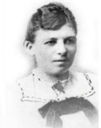
Emma Trosse was a German teacher and school administrator. Trained as a teacher and later passing an examination to be a principal, Trosse began her career working in public schools and as a private tutor. In 1895, she published one of the first scientific works on homosexuality and advocated for legal protections for homosexuals. She was the first known woman to scientifically discuss lesbianism. She also published books analyzing ancient medical practices in medieval Europe, and among the Greeks and Egyptians. After her marriage, she became a clinician in her husband's diabetes clinic, and began writing literature on diabetes.

The Häuschen is a hill, 506.5 m above sea level (NHN), in the Eifel mountains. It rises near Ahrweiler in the county of Ahrweiler in the German state of Rhineland-Palatinate.

Count Ernst von Isenburg-Grenzau was a Spanish general in the Thirty Years' War and the last representative of the Isenburg-Grenzau line.
{{cite web}}: CS1 maint: archived copy as title (link)