An agglomeration community is a government structure in France, created by the Chevènement Law of 1999. It is one of four forms of intercommunality, less integrated than a métropole or a communauté urbaine but more integrated than a communauté de communes. Agglomeration communities consist of a commune of at least 15,000 inhabitants and its independent suburbs.

The Gulf of Morbihan is a natural harbour on the coast of the Département of Morbihan in the south of Brittany, France. This English name is taken from the French version: le golfe du Morbihan. It is more accurately called 'the Morbihan' directly from its Breton name which is Ar Mor Bihan, meaning 'the little sea', as opposed to the Atlantic Ocean outside,. Legend says that there are as many islands in the Gulf as there are days of the year. However, this is untrue and the gulf has about 40, depending on the tide. Many islands are private property, except the largest two, l'Île-aux-Moines and l'Île-d'Arz.

The following is a list of the 250 communes of the Morbihan department of France.

The arrondissement of Vannes is an arrondissement of France in the Morbihan department in the Brittany region. Since the January 2017 reorganization of the arrondissements of Morbihan, it has 99 communes.

The Agglomération du Choletais, also simply known as CAC, is the intercommunal structure gathering the city of Cholet and its suburbs.
The Communauté d'agglomération Saumur Val de Loire is an intercommunal structure in the Loire Valley gathering 45 communes including Saumur and Montsoreau. It is located in the Maine-et-Loire département, in the Pays de la Loire région, western France. It was formed on 1 January 2017 by the merger of the former Communauté d'agglomération de Saumur Loire Développement, the Communauté de communes Loire Longué, the Communauté de communes du Gennois and the Communauté de communes de la région de Doué-la-Fontaine.
The Communauté d'agglomération du Pays de Fontainebleau is a communauté d'agglomération in the Seine-et-Marne département and in the Île-de-France région of France. It was formed in January 2017 by the merger of the former Communauté de communes du pays de Fontainebleau, the Communauté de communes entre Seine et Forêt and several communes from other communities.
The Communauté d'agglomération Melun Val de Seine is a communauté d'agglomération in the Seine-et-Marne département and in the Île-de-France région of France.
The Communauté d'agglomération du Pays de Meaux (CAPM) is a communauté d'agglomération in the Seine-et-Marne département and in the Île-de-France région of France. The 4 communes of the former Communauté de communes des Monts de la Goële were merged into it on 1 January 2017.
The Communauté de communes du Pays de Coulommiers is a former communauté de communes in the Seine-et-Marne département and in the Île-de-France région of France. It was created in January 2013 by the merger of the former Communauté de communes de la Brie des Templiers and the Communauté de communes Avenir et développement du secteur des Trois Rivières. In January 2017 it was joined by the communes of the former Communauté de communes de la Brie des Moulins. It was merged into the new Communauté d'agglomération Coulommiers Pays de Brie in January 2018.
The Communauté d'agglomération Bourges Plus is the communauté d'agglomération, an intercommunal structure, centred on the city of Bourges. It is located in the Cher department, in the Centre-Val de Loire region, central France. It was created October 21, 2002. Its population was 100,705 in 2014, of which 68,869 in Bourges proper.
Communauté d'agglomération du Grand Annecy is the communauté d'agglomération, an intercommunal structure, centred on the city of Annecy. It is located in the Haute-Savoie department, in the Auvergne-Rhône-Alpes region, southeastern France. It was created in January 2017 by the merger of the former communauté de l'agglomération d'Annecy and four communautés de communes. Its population was 203,078 in 2014, of which 128,422 in Annecy proper.
The canton of Séné is an administrative division of the Morbihan department, northwestern France. It was created at the French canton reorganisation which came into effect in March 2015. Its seat is in Séné.
The Communauté d'agglomération Versailles Grand Parc is the communauté d'agglomération, an intercommunal structure, centred on the city of Versailles. It is located in the Yvelines and Essonne departments, in the Île-de-France region, northern France. It was created in November 2002. Its population was 269,179 in 2014, of which 87,550 in Versailles proper.
The Communauté d'agglomération Grand Paris Sud Seine-Essonne-Sénart is the communauté d'agglomération, an intercommunal structure, in the southern suburbs of Paris. It is located in the Essonne and Seine-et-Marne departments, in the Île-de-France region, northern France. It was created in January 2016. Its population was 347,022 in 2014. Its seat is in Courcouronnes.
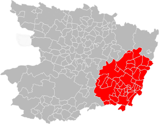
Communauté d'agglomération Lorient Agglomération is the communauté d'agglomération, an intercommunal structure, centred on the city of Lorient. It is located in the Morbihan department, in the Brittany region, northwestern France. It was created in January 2014. Its population was 206,836 in 2014, of which 59,296 in Lorient proper.
Communauté d'agglomération Plaine Vallée is the communauté d'agglomération, an intercommunal structure, covering northwestern suburbs of Paris. It is located in the Val-d'Oise department, in the Île-de-France region, northern France. It was created in January 2016. Its population was 183,063 in 2014. Its seat is in Montmorency.
The Communauté d'agglomération des Deux Baies en Montreuillois is a communauté d'agglomération, an intercommunal structure, in the Pas-de-Calais department, in the Hauts-de-France region, northern France. It was created in January 2017 by the merger of the former communautés de communes Montreuillois, Opale Sud and Mer et Terres d'Opale. Its population was 68,673 in 2014. Its seat is in Montreuil.
Communauté d'agglomération du Centre de la Martinique is the communauté d'agglomération, an intercommunal structure, centred on the city of Fort-de-France. It is located in Martinique, an overseas department and region of France. It was created in January 2001. Its population was 162,938 in 2014, of which 84,696 in Fort-de-France proper.
The Communauté d'agglomération Coulommiers Pays de Brie is the communauté d'agglomération, an intercommunal structure, centred on the town of Coulommiers. It is located in the Seine-et-Marne department, in the Île-de-France region, north-central France. It was created in January 2018 by the merger of the former Communauté de communes du Pays de Coulommiers and the Communauté de communes du Pays Fertois. Its population was 76,612 in 2015, of which 15,476 in Coulommiers.


