
Small hydro is the development of hydroelectric power on a scale suitable for local community and industry, or to contribute to distributed generation in a regional electricity grid. Exact definitions vary, but a "small hydro" project is less than 50 megawatts (MW), and can be further subdivide by scale into "mini" (<1MW), "micro" (<100 kW), "pico" (<10 kW). In contrast many hydroelectric projects are of enormous size, such as the generating plant at the Three Gorges Dam at 22,500 megawatts or the vast multiple projects of the Tennessee Valley Authority.

The Dez Dam, formerly known as Mohammad-Reza Shah Pahlavi Dam, before the 1979 Revolution, is an arch dam on the Dez River in the southwestern province of Khuzestan, Iran. It was built between 1959 and 1963 during the rule of Mohammad Reza Pahlavi, the last Shah of Iran, with contacting an Italian consortium and is owned by the Khuzestan Water & Power Authority. The dam is 203 metres (666 ft) high, making it one of the highest in the country, and has a reservoir capacity of 3,340,000,000 m3 (2,710,000 acre⋅ft). At the time of construction the Dez Dam was Iran's biggest development project. The primary purpose of the dam is hydroelectric power production and irrigation. It has an associated 520 MW power station and its reservoir helps irrigate up to 80,500 ha of farmland. US$42 million of the cost to construct the dam came from the World Bank.
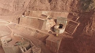
The Roghun Dam is an embankment dam under construction on the Vakhsh River in southern Tajikistan. The dam is situated 110 km from Dushanbe. It is one of the planned hydroelectric power plants of Vakhsh Cascade.

The Nurek Dam is an earth-fill embankment dam on the Vakhsh River in Tajikistan. Its primary purpose is hydroelectric power generation and its power station has an installed capacity of 3,015 MW. Construction of the dam began in 1961 and the power station's first generator was commissioned in 1972. The last generator was commissioned in 1979 and the entire project was completed in 1980 when Tajikistan was still a republic within the Soviet Union, becoming the tallest dam in the world at the time. At 304 m (997 ft), it is currently the second tallest man-made dam in the world, after being surpassed by Jinping-I Dam in 2013. The Rogun Dam, also along the Vakhsh in Tajikistan, may exceed it in size when completed.
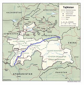
The Vakhsh, also known as the Surkhob in north-central Tajikistan and as the Kyzyl-Suu in Kyrgyzstan, is a Central Asian river and one of the main rivers of Tajikistan. It is a tributary of the Amu Darya river.

The Gandhi Sagar Dam is one of the four major dams built on India's Chambal River. The dam is located in the Mandsaur district of the state of Madhya Pradesh. It is a masonry gravity dam, standing 62.17 metres (204.0 ft) high, with a gross storage capacity of 7.322 billion cubic metres from a catchment area of 22,584 km2 (8,720 sq mi). The dam's foundation stone was laid by Prime Minister of India Pandit Jawaharlal Nehru on 7 March 1954, and construction of the main dam was done by leading contractor Dwarka Das Agrawal & Associates and was completed in 1960. Additional dam structures were completed downstream in the 1970s.

Nagarjuna Sagar Dam is a masonry dam across the Krishna River at Nagarjuna Sagar which straddles the border between Palnadu district in Andhra Pradesh and Nalgonda district in Telangana. The dam provides irrigation water to the districts of Krishna, Guntur, Palnadu, Prakasam and parts of West Godavari districts of Andhra Pradesh and also Nalgonda, Suryapet, Khammam, Bhadradri Kothagudem districts of Telangana. It is also a source of electricity generation for the national grid.

Hirakud Dam is built across the Mahanadi River, about 10 kilometres (6.2 mi) from Sambalpur in the state of Odisha in India. It is the longest earthen dam in the world. Behind the dam extends a lake, Hirakud Reservoir, 55 km (34 mi) long. It is one of the first major multipurpose river valley projects started after India's independence. Hirakud Reservoir was declared a Ramsar site on 12 October 2021.

The Kajaki Dam is "an earth and rockfill embankment type dam" located on the Helmand River in the Kajaki District of Helmand Province in Afghanistan, about 161 km (100 mi) northwest of Kandahar. It has a hydroelectric power station, which is operated by the Helmand and Arghandab Valley Authority through the Ministry of Energy and Water.
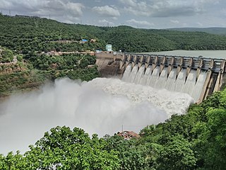
The Srisailam Dam is constructed across the Krishna River in Nandyal district, Andhra Pradesh and Nagarkurnool district, Telangana near Srisailam temple town and is the 2nd largest capacity working hydroelectric station in India.

Ghazi-Barotha Hydropower Project is a 1,450 MW run-of-the-river hydropower, connected to the Indus River. It is located about 10 km (6.2 mi) west of Attock in the Punjab province and east of Haripur in the Khyber Pakhtunkhwa province of Pakistan. Construction of the project began in 1995. It consists of five generators, each possessing a maximum power generation capacity of 290 MW. The inauguration of the plant took place on 19 August 2003, presided over by the then President General Pervez Musharraf. It also saw the commissioning of the first two of the five generators i.e. Unit 1 and Unit 2. The last generator was commissioned on 6 April, 2004, and the project was completed by December the same year. It costed US$2.1 billion with funding from Pakistan's Water and Power Development Authority, the World Bank, Asian Development Bank, Japan Bank for International Cooperation, Kreditanstalt für Wiederaufbau, European Investment Bank and Islamic Development Bank.
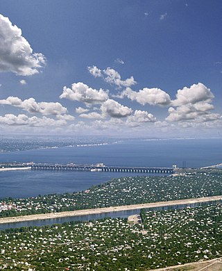
The Volga Hydroelectric Station or Volga GES also known as the 22nd Congress of the CPSU Stalingrad/Volgograd Hydroelectric Power Station, is the largest hydroelectric station in Europe, and the last of the Volga-Kama Cascade of dams, immediately before the Volga River flows into the Caspian Sea. It was the largest powerstation in the world between 1960 and 1963. Today, it is operated by the partly government-owned electricity company RusHydro.

The Mingachevir Dam is an earth-fill embankment dam on the Kura River just north of Mingachevir in Azerbaijan. It serves several purposes, including hydroelectric power production and water storage for irrigation. The Mingachevir reservoir, behind the dam, supplies water to the Upper Qarabag and Upper Sirvan channels which help irrigate about 1,000,000 ha of farmland in the country. Its six Francis turbine-generators were overhauled or replaced with 70 megawatts (94,000 hp) sets in 2000. Mingachevir reservoir has a storage capacity of 15.730 cubic kilometres (12,753,000 acre⋅ft), covering 605 km2 (234 sq mi). The length of the dam is 1,550 metres (5,090 ft), its width is 16 metres (52 ft) and height is 80 m (260 ft). It is the largest hydroelectric power station in the South Caucasus, and is located on Kura river, not far from Mingachevir city.

The Bhimgoda Barrage, also referred to as the Bhimgoda Weir or Bhimgoda Head Works, is a barrage on the Ganges River at Har ki Pauri near Haridwar in Haridwar district, Uttarakhand, India. Built as the headworks of the Upper Ganges Canal, an initial barrage was completed by 1854 and replaced twice; the final one completed in 1983. The primary purpose for the barrage is irrigation but it also serves to provide water for hydroelectric power production and control floods. The area behind the barrage is known as the Neel Dhara Bird Sanctuary and is a popular destination for various waterbirds and tourists.
The Daguangba Dam is a multi-purpose dam on the Changhua River in Hainan Province, China. It is located 35 km (22 mi) east of Dongfang. As the primary component of the Daguangba Multipurpose Project, the dam was constructed between 1990 and 1995. It serves to provide water for both hydroelectric power generation and agriculture. It supports a 240 MW power station and supplies water for the irrigation of 12,700 ha. It is also the largest dam and hydroelectric power station in Hainan.

The Nangbeto Dam is an embankment dam on the Mono River in the Plateaux Region of Togo. It was constructed between 1984 and 1987 for the purpose of providing hydroelectric power to both Togo and Benin as well as creating fisheries and supplying water for irrigation. The dam's 65.6 megawatts (88,000 hp) power station was commissioned in June 1987. The project was financed by the World Bank and African Development Bank at a cost of US$98.22 million.
The Kayrakkum Dam, also spelt variously as Kayrakum, Kairakum, Qayraqqum or Qayroqqum, is an embankment dam on the Syr Darya River near the town of Kayrakkum in Sughd Province, Tajikistan. It is situated on the western edge of the Fergana Valley and creates Kayrakkum Reservoir. The reservoir supplies water for irrigation, primarily in Uzbekistan downstream, and hydroelectric power production. The reservoir is also a Ramsar site. The dam's power station has an installed capacity of 126 MW and is operated by Barki Tojik. Construction on the dam began in 1952. It began to impound its reservoir in 1956 and the first two generators were commissioned that year. The other four were operational in 1957 and the project was complete in 1959. The power station is currently undergoing a rehabilitation which should be completed in 2020. Two new and larger turbines will increase the installed capacity to 142 MW.
The Baipaza Dam is a concrete face rock-fill dam on the Vakhsh River about 9 km (5.6 mi) southeast of Yovon in Khatlon Province, Tajikistan. A purpose of the dam is hydroelectric power generation and it supports a 600 MW power station. The first three 150 MW Francis turbine-generators were commissioned in 1985, the fourth in 1986. Its reservoir also holds water for the irrigation of some 40,000 ha in the Yovon and Obikiik Valleys to the west. This is accomplished by a 7.3-kilometre-long (4.5 mi) tunnel which runs from the right back of the reservoir and through a mountain to the valley.
The Andijan Dam is a buttress dam on the river Kara Darya near Andijan in Andijan Region, Uzbekistan. Its reservoir, known as the Andijan Reservoir in Uzbekistan and Kempir-Abad Reservoir in Kyrgyzstan, covers 56 km2 (22 sq mi) and stretches into the neighboring Osh Region of Kyrgyzstan.

The Vorotan Cascade, or the ContourGlobal Hydro Cascade, is a cascade on the Vorotan River in Syunik Province, Armenia. It was built to produce hydroelectric power and provide irrigation water. The Vorotan Cascade consists of three hydroelectric power plants and five reservoirs with a combined installed capacity of 404.2 MW. It is one of the main power generation complexes in Armenia.

