
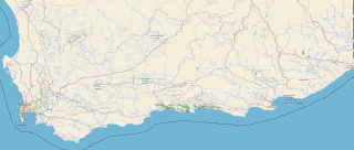
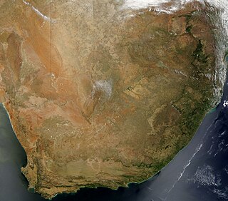
South Africa occupies the southern tip of Africa, its coastline stretching more than 2,850 kilometres from the desert border with Namibia on the Atlantic (western) coast southwards around the tip of Africa and then northeast to the border with Mozambique on the Indian (eastern) coast. The low-lying coastal zone is narrow for much of that distance, soon giving way to a mountainous escarpment that separates the coast from the high inland plateau. In some places, notably the province of KwaZulu-Natal in the east, a greater distance separates the coast from the escarpment. Although much of the country is classified as semi-arid, it has considerable variation in climate as well as topography. The total land area is 1,220,813 km2 (471,359 sq mi). It has the 23rd largest Exclusive Economic Zone of 1,535,538 km2 (592,875 sq mi).

Mossel Bay is a harbour town of about 120,000 people on the Southern Cape of South Africa. It is an important tourism and farming region of the Western Cape Province. Mossel Bay lies 400 kilometres east of the country's seat of parliament, Cape Town, and 400 km west of Port Elizabeth, the largest city in the Eastern Cape. The older parts of the town occupy the north-facing side of the Cape St Blaize Peninsula, whilst the newer suburbs straddle the Peninsula and have spread eastwards along the sandy shore of the Bay.

The Karoo is a semi-desert natural region of South Africa. No exact definition of what constitutes the Karoo is available, so its extent is also not precisely defined. The Karoo is partly defined by its topography, geology and climate, and above all, its low rainfall, arid air, cloudless skies, and extremes of heat and cold. The Karoo also hosted a well-preserved ecosystem hundreds of million years ago which is now represented by many fossils.
The Garden Route is a 300-kilometre (190 mi) stretch of the south-eastern coast of South Africa which extends from Witsand in the Western Cape to the border of Tsitsikamma Storms River in the Eastern Cape. The name comes from the verdant and ecologically diverse vegetation encountered here and the numerous estuaries and lakes dotted along the coast. It includes towns such as Witsand, Heidelberg, Riversdale, Stilbaai, Albertinia, Gouritsmond, Knysna, Plettenberg Bay, Mossel Bay, Oudtshoorn, Great Brak River, Little Brak River, Wilderness, Sedgefield and Nature's Valley; with George, the Garden Route's largest city and main administrative centre.

The Pilanesberg National Park is located north of Rustenburg in the North West Province of South Africa. The park borders on the Sun City entertainment complex. It is administered by the North West Parks and Tourism Board.

Table Mountain National Park, previously known as the Cape Peninsula National Park, is a national park in Cape Town, South Africa, proclaimed on 29 May 1998, for the purpose of protecting the natural environment of the Table Mountain chain, and in particular the rare fynbos vegetation. The park is managed by South African National Parks. The property is included as part of the UNESCO Cape Floral Region World Heritage Site.

Madikwe Game Reserve is a protected area in South Africa and was named after the Madikwe or Marico River, on whose basin it is located. It comprises 750 km2 (290 sq mi) of bushland north of the small town of Groot-Marico up to the border with Botswana. It was opened in 1994.

The Waterberg is a mountainous massif of approximately 654,033 hectare in north Limpopo Province, South Africa. The average height of the mountain range is 600 m with a few peaks rising up to 2,000 m above sea level. Vaalwater town is located just north of the mountain range. The extensive rock formation was shaped by hundreds of millions of years of riverine erosion to yield diverse bluff and butte landform. The ecosystem can be characterised as a dry deciduous forest or Bushveld. Within the Waterberg there are archaeological finds dating to the Stone Age, and nearby are early evolutionary finds related to the origin of humans.
Inkwenkwezi Private Game Reserve, is located approximately 30 km north-east of East London, and is situated within an area of 4500 hectares encompassing five different biomes in the Wild Coast region of South Africa's Eastern Cape province. It is home to four of the Big Five game; namely lion, buffalo, leopard and rhinoceros; as well as giraffe, zebra, a variety of antelope, and many other smaller species.
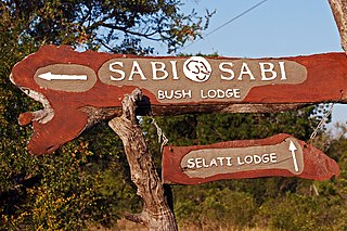
Sabi Sabi is a private game reserve in South Africa, situated in the Sabi Sand Game Reserve which flanks the south western section of the Kruger National Park. The Sabi Sand Reserve is one of the parks that make up the Greater Kruger National Park.

The wildlife of Zimbabwe occurs foremost in remote or rugged terrain, in national parks and private wildlife ranches, in miombo woodlands and thorny acacia or kopje. The prominent wild fauna includes African buffalo, African bush elephant, black rhinoceros, southern giraffe, African leopard, lion, plains zebra, and several antelope species.
Mokala National Park is a reserve established in the Plooysburg area south-west of Kimberley in the Northern Cape, South Africa on 19 June 2007. The size of the park is 26,485 hectares. Mokala is the Setswana name for the magnificent camel thorn, a tree species typical of the arid western interior and common in the area. There is currently 70 km of accessible roads in the national park.

Hlane Royal National Park is a national park in Eswatini, roughly 67 km northeast of Manzini along the MR3 road. Prior to being designated a public park, it was a private royal hunting ground. Hlane, meaning 'wilderness', was named by King Sobhuza II. It is now held in trust for the nation by His Majesty King Mswati III, and is managed by Big Game Parks, a privately owned body.

Renosterveld is a term used for one of the major plant communities and vegetation types of the Cape Floristic Region which is located in southwestern and southeastern South Africa, in southernmost Africa. It is an ecoregion of the Mediterranean forests, woodlands, and scrub biome.

Wolwedans Dam is a concrete dam in South Africa located on the Great Brak River near Mossel Bay, Western Cape, South Africa. The dam is the main source of water for the municipality of Mossel Bay as well as the gas-to-liquids refinery PetroSA. The dam serves mainly for municipal and industrial water supply purposes.
Boggomsbaai is a coastal holiday village in Mossel Bay Municipality in the Western Cape province of South Africa.

Great Brak River is a coastal village in the Mossel Bay Local Municipality in the Western Cape province of South Africa. It is a historic village built around the lagoon of the Great Brak River, 17 kilometres (11 mi) north-northeast of the town of Mossel Bay.
The fauna of South Africa is diverse and largely typical of the ecosystems in Africa. South Africa is ranked sixth out of the world's 17 megadiverse countries. Many endemic species are unique to South Africa. The country is among the world leaders in conservation, but at the time wildlife is threatened by poaching and canned hunting.

The Buffelskloof Formation is a geological formation found in the Western Cape province in South Africa. It is the uppermost of the four formations found within the Uitenhage Group of the Algoa Basin. It is considered an informal formation by some of the literature as it is very thin and only outcrops as isolated horizons in the Oudshoorn-Gamtoos, Herbertsdale-Mossel Bay, and Heidelberg-Riversdale Basins. Along the Worcester-Pletmos Basin, it occurs in patches along the southern flanks of the Langeberg mountain range - from Worcester in the west and as far as Mossel Bay in the east. From Mossel Bay this formation is inter fingered by the informal Hartenbos Formation. The Buffelskloof and Hartenbos Formations only occur in the Oudshoorn-Gamtoos and Herbertsdale-Mossel Bay basins and seem to correlate to the Sundays River Formation in age.
