
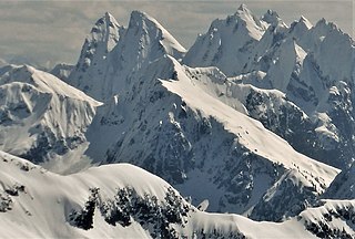
North Cascades National Park is an American national park in the state of Washington. At more than 500,000 acres (200,000 ha), it is the largest of the three National Park Service units that comprise the North Cascades National Park Complex. North Cascades National Park consists of a northern and southern section, bisected by the Skagit River that flows through the reservoirs of Ross Lake National Recreation Area. Lake Chelan National Recreation Area lies on the southern border of the south unit of the park. In addition to the two national recreation areas, other protected lands including several national forests and wilderness areas, as well as Canadian provincial parks in British Columbia, nearly surround the park. North Cascades National Park features the rugged mountain peaks of the North Cascades Range, the most expansive glacial system in the contiguous United States, the headwaters of numerous waterways, and vast forests with the highest degree of flora biodiversity of any American national park.

The Nooksack River is a river in western Whatcom County of the northwestern U.S. state of Washington, draining extensive valley systems within the North Cascades around Mount Shuksan, Mount Baker and the Twin Sisters, and a portion of Fraser Lowland south of the Canada–United States border.

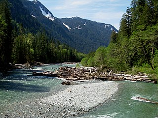
The Skagit River is a river in southwestern British Columbia in Canada and northwestern Washington in the United States, approximately 150 mi (240 km) long. The river and its tributaries drain an area of 1.7 million acres (690,000 hectares) of the Cascade Range along the northern end of Puget Sound and flows into the sound.

The Sauk River is a tributary of the Skagit River, approximately 45 miles (72 km) long, in northwestern Washington in the United States. It drains an area of the high Cascade Range in the watershed of Puget Sound north of Seattle. The river is a popular destination for fly fishing. It is a National Wild and Scenic River.

The Stillaguamish River is a river in the northwestern region of the U.S. state of Washington. It is mainly composed of two forks, the longer North Fork Stillaguamish and the South Fork Stillaguamish. The two forks join near Arlington. From there the Stillaguamish River proper flows for 22 miles (35 km) to Puget Sound. The river's watershed drains part of the Cascade Range north of Seattle.
The Baker River is an approximately 30-mile (48 km), southward-flowing tributary of the Skagit River in northwestern Washington in the United States. It drains an area of the high North Cascades in the watershed of Puget Sound north of Seattle, and east of Mount Baker. With a watershed of approximately 270 square miles (700 km2) in a complex of deep valleys partially inside North Cascades National Park, it is the last major tributary of the Skagit before the larger river reaches its mouth on Skagit Bay. The river flows through Concrete, Washington, near its mouth and has two hydroelectric dams owned by Puget Sound Energy.

The Naches River is a tributary of the Yakima River in central Washington in the United States. Beginning as the Little Naches River, it is about 75 miles (121 km) long. After the confluence of the Little Naches and Bumping River the name becomes simply the Naches River. The Naches and its tributaries drain a portion of the eastern side of the Cascade Range, east of Mount Rainier and northeast of Mount Adams. In terms of discharge, the Naches River is the largest tributary of the Yakima River.

The Sol Duc River is a river in the U.S. state of Washington. About 78 miles (126 km) long, it flows west through the northwest part of the Olympic Peninsula, from the Olympic Mountains of Olympic National Park and Olympic National Forest, then through the broad Sol Duc Valley. Near the Pacific Ocean the Sol Duc River joins the Bogachiel River, forming the Quillayute River, which flows about 4 miles (6.4 km) to the Pacific Ocean at La Push. Although the Quillayute River is short, its large tributary rivers—the Sol Duc, Bogachiel, Calawah, and Dickey Rivers—drain the largest watershed of the northern Olympic Peninsula, 629 square miles (1,630 km2). The Sol Duc's watershed is the largest of the Quillayute's tributaries, at 219 square miles (570 km2).
The Mowich River is a river in the U.S. state of Washington. Its watershed drains a portion of the western side of Mount Rainier, part of the Cascade Range. The river has two main headwater branches, the South Mowich River and the North Mowich River. The South Mowich is significantly larger and sometimes considered the main river. The Mowich and its tributaries drain several of Mount Rainier's glaciers. The upper portion of its watershed is contained within Mount Rainier National Park. The river flows into the Puyallup River in the foothills west of Mount Rainier.
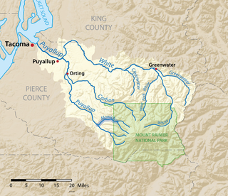
The Greenwater River is a river in the U.S. state of Washington. Its watershed drains a portion of the Cascade Range east and northeast of Mount Rainier, including parts of the Norse Peak Wilderness. It flows into the White River at Greenwater, which eventually flows into Puget Sound via the Puyallup River. The Greenwater River defines part of the boundary between King and Pierce counties.
The Cascade River is a river in the U.S. state of Washington. It is a tributary of the Skagit River which it joins at the city of Marblemount. It is a National Wild and Scenic River.

Mount Blum, or Mount Bald, is a 7,685-foot (2,342 m) summit of the North Cascades range in Washington state, on the western edge of North Cascades National Park. It is the highest summit of a string of mountain peaks located east of Mount Shuksan and west of the Picket Range. Two small active glaciers rest on its northern flank. Mount Blum was named after John Blum, a United States Forest Service fire patrol pilot who perished in a plane crash near Snoqualmie Pass in 1931.

Mount Triumph is a summit in the North Cascades range of Washington state. Located approximately 5.5 miles (8.9 km) west-northwest of the town of Newhalem, it was named by Lage Wernstedt, a surveyor with the U.S. Forest Service. A significant peak in North Cascades National Park, Mount Triumph is one of its "outstanding sights" and is well known among regional climbers for its lack of easy climbing routes to the summit. Despite its moderate elevation, its local relief is dramatic. With the terrain deeply dissected by the valleys of Bacon Creek on the west and Goodell Creek on the east, it rises 1 mile (1.6 km) in less than 2 miles (3.2 km) on the latter side.

Buckner Mountain is a tall peak in the North Cascades of Washington state and in the Stephen Mather Wilderness of North Cascades National Park. At 9,114 feet (2,778 m) in elevation it is the highest in Skagit County and one of about ten of Washington's non-volcanic peaks above 9,000 feet high. It is ranked as the 14th highest peak in the state, and the third highest peak in North Cascades National Park.

Boston Peak is a tall peak in the North Cascades in the U.S. state of Washington and within North Cascades National Park. At 8,894 feet (2,711 m) in elevation it is the 26th highest peak in Washington. Its nearest higher neighbor is Buckner Mountain, 1.66 miles (2.67 km) to the east.

Mount Spickard is a 8,980-foot (2,740 m) mountain peak in the North Cascades, a mountain range in the U.S. state of Washington. Located 2 miles (3.2 km) south of the Canada–US border, it is part of the Chilliwack Group, a subrange of the Skagit Range which is part of the North Cascades. It is composed mainly of gneiss and is part of two major drainage basins: that of the Skagit River and Fraser River.

Icicle Creek is a non navigable stream in the U.S. state of Washington. It originates at Josephine Lake near the crest of the Cascade Range and flows generally east to join the Wenatchee River near Leavenworth. Icicle Creek's drainage basin is mountainous and mostly undeveloped land within the Wenatchee National Forest and the Alpine Lakes Wilderness. The final 6 miles (10 km) of the creek are moderately developed with scattered homes and pasture, a golf course, children's camp, a small housing development called Icicle Island Club, and the Leavenworth National Fish Hatchery. Some water is diverted from the creek for municipal use by the City of Leavenworth at Icicle Creek river mile 5.6. Near Leavenworth, the wheelchair-accessible Icicle Creek Nature Trail, a National Recreation Trail designated in 2005, runs 1.0 mile (1.6 km) along a historic creek channel.

Mount Ross is a 6,052-foot (1,845 m) mountain summit located in the North Cascades, in Whatcom County, Washington, United States.

Crooked Bum is a 6,937-foot-elevation mountain summit on the crest of the North Cascades in the U.S. state of Washington. It is located in the Okanogan–Wenatchee National Forest on the shared border of Skagit County and Chelan County. It is situated immediately west of Rainy Pass and two miles east of Corteo Peak. The scenic and popular Maple Pass Trail traverses the south slope of the peak while staying above Lake Ann. Precipitation runoff from the north slope of Crooked Bum drains into Granite Creek which is a tributary of the Skagit River, whereas the south side drains into Bridge Creek which is a tributary of the Chelan River.
Mount Crowder is a remote 7,082-foot (2,159-metre) mountain summit in the Picket Range of the North Cascades, in Whatcom County of Washington state. Mount Crowder is situated in North Cascades National Park and Stephen Mather Wilderness. Neighbors include Mount Fury, 1.64 mi (2.64 km) to the northeast, and Twin Needles is set 2.3 mi (3.7 km) to the southeast. Precipitation runoff from this peak drains south into headwaters of Goodell Creek, and northwest into Picket Creek which is a tributary of the Baker River. Topographic relief is significant as the summit rises 4,300 feet above Goodell Creek in approximately one mile.

