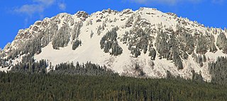
Mount Terror is a mountain of the Cascade Range, located in the northwestern corner of Washington in Whatcom County. The peak is in North Cascades National Park, about 15.7 miles (25.3 km) south of the Canada–United States border.
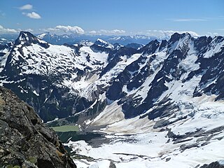
Luna Peak is the second highest mountain in the Picket Range, an extremely rugged subrange of the North Cascades in the American state of Washington. It is located within North Cascades National Park. It is notable for its large local relief and isolated position on a far-flung eastern ridge of the Pickets. For example, it rises over 6,560 ft (2,000 m) in 1.8 mi (2.9 km) above McMillan Creek to the south.

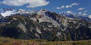
The Picket Range is a small, extremely rugged subrange of the North Cascades in the northwestern part of the American state of Washington. It is entirely contained within North Cascades National Park. It is about 6 miles (9.7 km) long, running northwest–southeast, and lies north of the Skagit River, west of Ross Lake, and east of Mounts Baker and Shuksan. There are at least 21 peaks in the range over 7,500 ft (2,300 m) high.
North Gardner Mountain is a mountain in the North Cascades of Washington state. The mountain is located in the Okanogan–Wenatchee National Forest and is the highest point in Okanogan County, Washington, and the 23rd highest mountain in the state.

Mount Blum, or Mount Bald, is a 7,685-foot (2,342 m) summit of the North Cascades range in Washington state, on the western edge of North Cascades National Park. It is the highest summit of a string of mountain peaks located east of Mount Shuksan and west of the Picket Range. Two small active glaciers rest on its northern flank. Mount Blum was named after John Blum, a United States Forest Service fire patrol pilot who perished in a plane crash near Snoqualmie Pass in 1931.

Whatcom Peak is in North Cascades National Park in the U.S. state of Washington. Whatcom Peak is .50 mi (0.80 km) north of Challenger Glacier and the Whatcom Glacier descends from the northeast slopes of the peak. An unnamed hanging glacier descends along the northwest flank of the peak. This mountain is set between Mount Challenger and Easy Peak.

Crooked Thumb Peak is located in North Cascades National Park in the U.S. state of Washington. Located in the northern section of the park, Crooked Thumb Peak is in the Picket Range and is .50 mi (0.80 km) south of Mount Challenger and the same distance north of Phantom Peak.
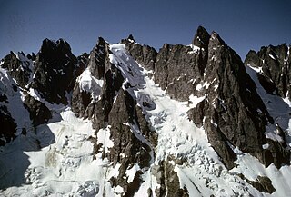
Mount Degenhardt, elevation 8,000+ ft, is a mountain peak in the Picket Range in the U.S. state of Washington and within North Cascades National Park. Located in the northern section of the park, Mount Degenhardt is .30 mi (0.48 km) southeast of Mount Terror, .28 mi (0.45 km) west of Inspiration Peak. and .75 mi (1.21 km) west of McMillan Spire. Mount Degenhardt is named after William Degenhardt, an early 20th century mountain climber. The Terror Glacier lies on the southeast slopes of Mount Degenhardt.

McMillan Spire is a mountain peak in the Picket Range in the U.S. state of Washington and within North Cascades National Park. The peak lies .75 mi (1.21 km) east of Mount Degenhardt, and 0.47 mi (0.76 km) east of Inspiration Peak. The subpeak known as East McMillan Spire is .14 mi (0.23 km) east of McMillan Spire and they are collectively referred to as the McMillan Spires. The Terror Glacier lies to the west of the peak.

Mount Larrabee is a 7,865-foot (2,397-metre) Skagit Range mountain summit situated 1.4 mile south of the Canada–United States border, in the North Cascades of Washington state. It is located immediately southeast of American Border Peak within the Mount Baker Wilderness, which is part of the Mount Baker-Snoqualmie National Forest, and near North Cascades National Park. It is notable for its reddish coloring caused by oxidation of Iron in the rock. The rock consists of reddish interbedded and interfolded phyllites and greenstone. Originally known as Red Mountain, the name was changed in 1951 to honor Charles F. Larrabee (1895–1950), of the prominent Larrabee family of Bellingham, Washington. The name was officially adopted in 1951 by the U.S. Board on Geographic Names.

Ruth Mountain is a 7,115 ft (2,170 m) Skagit Range summit located two miles south of Hannegan Pass in the North Cascades of Washington state. The name honors Ruth Cleveland, daughter of President Grover Cleveland. This mountain's name was officially adopted in 1952 by the United States Board on Geographic Names. Ruth Mountain is situated on the shared border of North Cascades National Park and the Mount Baker Wilderness, which is part of the Mount Baker-Snoqualmie National Forest. The summit offers views of Mount Shuksan, East Nooksack Glacier, Seahpo Peak, Nooksack Tower, Icy Peak, Mount Sefrit, Mineral Mountain, and the Picket Range. The melting and receding Ruth Glacier on the north slope of Ruth creates the headwaters for the Chilliwack River. Precipitation runoff also finds its way into the Nooksack and Baker Rivers.

Mix-up Peak, also known as Mixup Peak, is a 7,440-foot (2,270-metre) mountain summit located on the shared boundary of Skagit County and Chelan County in Washington state. It is part of the North Cascades Range and is situated one mile south of Cascade Pass on the shared border of North Cascades National Park and Glacier Peak Wilderness. The nearest higher peak is Magic Mountain, 1.02 miles (1.64 km) to the east-southeast. Mix-up Peak is at the northern end of the Ptarmigan Traverse which is an alpine route to remote mountains such as Mount Formidable and Dome Peak. The Cache Glacier occupies a cirque below its eastern flank. Surface runoff on the east side the mountain drains into the Stehekin River, whereas precipitation runoff drains into the Cascade River from the west side.

Mount Misch is a remote 7,435 ft mountain summit in the North Cascades, in Skagit County of Washington state. It is the highest point of the Buckindy Range, or Buckindy Ridge. It is located 19 miles east-northeast of Darrington, Washington, and 15 miles north-northwest of Glacier Peak which is one of the Cascade stratovolcanoes. It is situated in the Glacier Peak Wilderness on land administered by the Mount Baker-Snoqualmie National Forest. Mount Misch was named by mountaineer and author Fred Beckey for his friend Peter Misch (1909-1987), University of Washington geology professor and mountaineer, who was renowned for his study of the North Cascades. Precipitation runoff from Mount Misch and the unnamed Goat Creek glacier on its east slope drains into tributaries of the Suiattle River and ultimately the Skagit River.

Inspiration Peak is a 7,880+ ft mountain summit located in the Picket Range within North Cascades National Park in the state of Washington. The peak lies 0.28 mi (0.45 km) east of Mount Degenhardt, and 0.47 mi (0.76 km) west of McMillan Spires. Terror Glacier remnants lie to the south of the peaks, and the McMillan Cirque glaciers hang on the north slopes. The first ascent of Inspiration Peak was made in 1940 by Fred Beckey and his brother Helmy via the West Ridge. Inspiration Peak can be seen from the North Cascades National Park Newhalem visitor center, weather permitting.
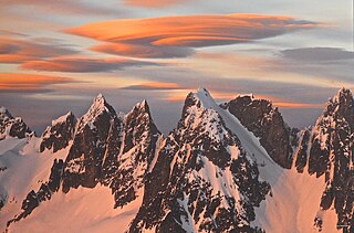
Twin Needles are a pair of 7,936-foot (2,419-metre) and 7,840+ ft spires located in the remote and rugged Picket Range within North Cascades National Park in the state of Washington. The peaks are situated 0.55 mi (0.89 km) west of Mount Terror which is the nearest higher peak. The Mustard Glacier lies on the northern slope of the peaks, and Himmelhorn lies immediately west. The first ascent of Twin Needles was made on August 17, 1932, by William Degenhardt, James Martin, and Herb Strandberg. Twin Needles can be seen from the 100 meter Sterling Munro Trail located behind the park's Newhalem Visitor Center.
Sauk Mountain is a 5,541-foot (1,689-metre) mountain summit located in Skagit County of Washington state. It is situated immediately north of Rockport State Park and the North Cascades Highway, on land managed by the Mount Baker-Snoqualmie National Forest. Sauk Mountain is positioned west of the crest of the North Cascades Range, approximately nine miles east of Concrete, Washington, and 17 miles north of the town of Darrington. Its nearest higher peak is Helen Buttes, 5.86 miles (9.43 km) to the northeast. A popular two-mile trail provides hikers with good views from the craggy summit of Mount Baker, Mount Shuksan, Mount Chaval, and the Picket Range. Precipitation runoff from Sauk Mountain drains into tributaries of the Skagit River.

Mount Arriva is an 8,215 ft (2,500 m) elevation mountain summit located in the North Cascades in the U.S. state of Washington. It is situated in North Cascades National Park, on the shared border of Chelan County and Skagit County. Despite its position only 1.55 mi (2.49 km) southwest of Easy Pass, and 3.7 mi (6.0 km) west of the North Cascades Highway, it is not visible from either. Its nearest higher peak is Black Peak, 2.57 mi (4.14 km) to the southeast. Mount Arriva has a secondary summit, called East Peak, which was first climbed in August 1940 by Fred Beckey, Jim Crooks, and Ed Kennedy. The first ascent of the true summit was made July 6, 1966, by Joe and Joan Firey, John and Irene Meulemans.

Mount Howard is a prominent 7,063 feet (2,153 m) mountain summit located west of Lake Wenatchee in Chelan County of Washington state. Mount Howard is the highest point of Nason Ridge, and is 1.37 mi (2.20 km) northeast of Rock Mountain, which is second-highest. This peak is set approximately midway between Stevens Pass and Lake Wenatchee, on land managed by the Okanogan–Wenatchee National Forest. Precipitation runoff from the peak drains into tributaries of the Wenatchee River. The mountain may have been named by a survey party, and first published in 1887.
Easy Peak is a 6,613-foot (2,016-metre) mountain summit in the Skagit Range of the North Cascades, in Whatcom County of Washington state. Easy Peak is situated in North Cascades National Park, and is often climbed during the Easy Ridge approach to Mount Challenger and the remote northern Pickets. Its nearest higher neighbor is Mineral Mountain, 2 mi (3.2 km) to the west, and Whatcom Peak is set 2.1 mi (3.4 km) to the east. Glacierets line the north slope of Easy Ridge between Easy Peak and Whatcom Peak. Precipitation runoff from this peak drains north into the Chilliwack River, or south into headwaters of the Baker River.
Trappers Peak is a 5,966-foot (1,818 m) elevation mountain summit located in the North Cascades of Washington state. It is situated within North Cascades National Park, Stephen Mather Wilderness, and Whatcom County. It rises steeply above Lower Thornton Lake which is set at the southwestern face of the mountain. Like many North Cascades peaks, Trappers Peak is more notable for its large, steep rise above local terrain than for its absolute elevation. Topographic relief is significant as the southeast aspect rises 5,500 feet (1,700 m) above the North Cascades Highway in approximately two miles. The nearest higher neighbor is Thornton Peak, 1.5 miles (2.4 km) to the northwest, Mount Triumph is two miles to the northwest, and Newhalem is three miles to the east-southeast. Precipitation runoff from the mountain drains into tributaries of the Skagit River. The summit of Trappers Peak is known for its grand view of the jagged peaks of the Picket Range.


