
Goodsprings is an unincorporated community in Clark County, Nevada, United States. The population was 229 at the 2010 census.
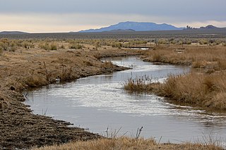
The White River is a small and discontinuous 138-mile-long (222 km) river located in southeastern Nevada notable for several endemic species of fish.
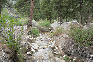
Carpenter Canyon is a canyon on the western side of the Spring Mountains, partially within the Humboldt-Toiyabe National Forest, in Clark County, southern Nevada west of the Las Vegas Valley.

The Pahranagat Valley is a Tonopah Basin landform in Lincoln County, Nevada.
Jean is a small commercial town in Clark County, Nevada, located approximately 12 mi (19 km) north of the Nevada-California state line along Interstate 15. Las Vegas is located about 30 mi (48 km) to the north. There are no residents of Jean, but many people in nearby communities like Primm and Sandy Valley have Jean listed in their mailing address because it is the location of the main post office for the 89019 ZIP code. Las Vegas Boulevard South ends about 2 mi (3.2 km) south of Jean, and it contiguously runs northbound past Las Vegas, ending near the I-15-US 93 Junction.

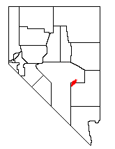
State Route 161 is a state highway in Clark County, Nevada. It is known as Goodsprings Road, connecting the town of Goodsprings to Interstate 15 at Jean. The route was part of State Route 53 prior to 1976.

Railroad Valley is one of the Central Nevada Desert Basins in the Tonopah Basin and is ~80 miles (130 km) long north-south and up to 20 miles (32 km) wide, with some southern areas running southwest to northeast. The southern end of the valley begins near Gray Top Mountain and stretches north all the way to Mount Hamilton. To the east are the Quinn Canyon, Grant, and White Pine Ranges, while to the west are the Pancake and Reveille Ranges. Most of the valley lies in Nye County, but it crosses into White Pine County at its northern end. The valley includes numerous springs including Kate Springs and Blue Eagle Springs, ranches such as the Blue Eagle Ranch, and 2 Tonopah Playas.
Diamond Valley is a valley basin between the Sulphur Spring Range and the Diamond Mountains, in central Nevada, the Western United States.

Lanfair Valley is located in the Mojave Desert in southeastern California near the Nevada state line. It is bounded on the north by the New York Mountains and Castle Mountains, on the east by the Piute Range, and on the south by the Woods Mountains and Vontrigger Hills. Joshua Trees can be found in most of the valley. Elevation is 4,045 feet.

The 3rd Congressional District of Nevada is a congressional district occupying the area south of Las Vegas, including Henderson, Boulder City and much of unincorporated Clark County. The district was initially created after the 2000 census.
The Quinn Canyon Range is a remote group of mountains in northeastern Nye County, and western Lincoln County in central Nevada in the western United States. Adaven is the only settlement in the mountains, now abandoned.

The Goodsprings Cemetery consists of 1.33 acres (0.54 ha) and is an old, continuing cemetery located southwest of Las Vegas, Nevada seven miles (11 km) from Jean and just before entering the town of Goodsprings.
Golden Valley is a census-designated place (CDP) in Washoe County, Nevada, United States. The population was 1,556 at the 2010 census. It is a northern suburb of the city of Reno and is part of the Reno–Sparks Metropolitan Statistical Area. Prior to 2010, it was listed by the U.S. Census Bureau as part of the Lemmon Valley–Golden Valley CDP.
Tule Springs Archaeological Site is an archeological site listed on the National Register of Historic Places that is located in the Las Vegas Valley of Nevada, United States. It is one of a few sites in the United States where humans were once thought to have lived alongside, and potentially hunted, extinct Ice Age megafauna, although this view is not supported by the available scientific data and is no longer generally accepted.

The Potosi mining district, or Potosi, was an area in Clark County of southern Nevada, U.S. It is listed on the National Register of Historic Places and includes three structures. The town was named after the famous silver-mining city of Potosi, Bolivia.
Jean Pass (north) is one of two passes on the west and northwest of the Jean Dry Lake basin, an endorheic basin bordering Jean, Nevada.
Shadow Valley is a north to northwest flowing drainage within the Mojave Desert of San Bernardino County, California. A section of Interstate 15 passes through the valley between Mountain Pass and Halloran Springs. The valley drains to the north from the west flank of the Mescal Range, the Ivanpah Mountains and Cima Dome within the Mojave National Preserve. North of I-15 the valley lies between Clark Mountains to the east and Shadow Mountain to the west. To the north of Shadow Mountain, Kingman Wash becomes the main drainage and turns to the west south of the Kingston Range. The Mesquite Mountains and the Mesquite Valley are to the northeast.
Potosi or Potosi Camp, was called Crystal City in the 1870s, a mining ghost town in Clark County, Nevada. It lies at an elevation of 5705 feet.
Wilson Pass is a gap in Clark County, Nevada. It lies at an elevation of 5033 feet in the Spring Mountains between Goodsprings Valley and Mesquite Valley.
Mesquite Valley is a valley in Clark County, Nevada and Inyo County and San Bernardino County, California. Mesquite is an endorheic basin with Mesquite Lake at is lowest point at an elevation of 2,536 feet / 773 meters. This valley trends northwest and southeast with a head at 35°40′07″N115°29′09″W to the southeast near State Line Pass and another head at 35°53′50″N115°46′55″W at the southwestern end of Pahrump Valley, at an elevation of 2,808 feet / 856 meters, between the Kingston Range and Black Butte to the northwest. It is bounded on the northeast by the Spring Mountains, by the Mesquite Mountains to the southwest and the Clark Mountains to the southeast.


