Related Research Articles

The River Plym is a river in Devon, England. It runs from Dartmoor in the centre of the county southwest to meet the River Meavy, then south towards Plymouth Sound. The river is popular with canoeists, and the Plym Valley Railway runs alongside a section of the river.

Dadford is a hamlet in the parish of Stowe, north Buckinghamshire, England.

Combe Raleigh is a village and civil parish in the county of Devon, England. The village lies about 1.5 miles north of the town of Honiton, and the parish is surrounded, clockwise from the north, by the parishes of Luppitt, Honiton, Awliscombe and Dunkeswell.

Cookbury is a village and civil parish in the local government district of Torridge, Devon, England. The parish, which lies about five miles east of the town of Holsworthy, is surrounded clockwise from the north by the parishes of Thornbury, Bradford, Ashwater, Hollacombe, and Holsworthy Hamlets. In 2001 its population was 158, little changed from the 146 residents it had in 1901.

Coleford is a small hamlet in Mid-Devon, England. It includes a pub, and also has a park.
All Saints is a civil parish in East Devon, Devon, England. It has a population of 498 according to the 2001 census. The parish includes the hamlets of All Saints, Smallridge, Churchill, Alston and Waggs Plot. This area also has one cricket pitch, a primary school, pre-school and a church.

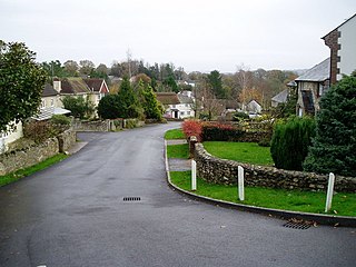
Berrynarbor is a village, civil parish and former manor in the North Devon district of Devon, England. According to the 2001 census the parish had a population of 749, increasing to 802 at the 2011 census. The village is located on the north coast of the county to the north of Exmoor, about three miles east of Ilfracombe. The parish is surrounded clockwise from the east by the parishes of Combe Martin, Kentisbury, East Down, Marwood, Bittadon, and Ilfracombe. Berrynarbor has within its purview to all sides a mixture of dense woodlands and farms and lies within the North Devon Area of Outstanding Natural Beauty.

Gooseham is a hamlet in northeast Cornwall, England, United Kingdom. It is situated six miles (11 km) north of Bude and is approximately one kilometre south of the border with Devon. The Marsland Valley nature reserve is near the hamlet. It is in the civil parish of Morwenstow, and its size been described by a resident as consisting of just "two houses and a wood rick."

Marsland Valley is a nature reserve situated in two large valleys which straddle the northern end of the Devon-Cornwall border. It is a designated nature reserve jointly managed by the Devon Wildlife Trust and the Cornwall Wildlife Trust. The reserve is a Special Area of Conservation, as well as forming part of two Sites of Special Scientific Interest; Steeple Point to Marsland Mouth on the Cornish side and Marsland to Clovelly Coast in Devon.

Lanteglos is a coastal civil parish in south Cornwall, England, United Kingdom. It is on the east side of the tidal estuary of the River Fowey which separates it from the town and civil parish of Fowey. The South West Coast Path runs along the southern coasts of the parish and much of the southern part of the parish lies in the Polruan to Polperro Site of Special Scientific Interest managed by the National Trust.
Flodaigh is a small island in Loch Roag on the west coast of Lewis in the Outer Hebrides of Scotland. It is about 33 hectares in extent and the highest point is 48 metres (157 ft). Its name derives from the Old Norse for "flat island".

New Mills is a hamlet in Cornwall, England, United Kingdom. It is situated in a wooded valley north of Ladock approximately seven miles (11 km) northeast of Truro at OS grid reference SW899523.

Churchbridge is a hamlet in Cornwall, England. It is a mile west of Duloe, and is situated on the West Looe River. Both banks of the river are wooded, and to the north of the bridge is a disused quarry and Tremadart Mills, marked as a corn mill on the 1882 map.

Degibna is a hamlet and farm in the parish of Helston, Cornwall, England, UK. It lies on the eastern bank of the largest natural freshwater lake in Cornwall, The Loe, and forms part of the Penrose Estate.
Old Mill is a hamlet in the civil parish of Stokeclimsland, Cornwall, England.

Millook is a deep coastal valley and hamlet in the parish of Poundstock, on the north coast of Cornwall, England.

Steeple Point to Marsland Mouth is a coastal Site of Special Scientific Interest (SSSI) in Cornwall, England, UK, noted for its biological characteristics.

Duckpool to Furzey Cove is a coastal Geological Conservation Review site and Site of Special Scientific Interest (SSSI) in north Cornwall, England, UK, noted for its geological interest.

Pancrasweek is a civil parish and hamlet in the far west of Devon, England forming part of the local government district of Torridge and lying about three miles north west of the town of Holsworthy.

Trevillet or Trevillett is a hamlet in Cornwall, England, United Kingdom. It is located within the civil parish of Tintagel, to the east of Bossiney village.
References
- ↑ Ordnance Survey: Landranger map sheet 190 Bude & Clovelly (Map). Ordnance Survey. ISBN 978-0-319-23145-6.
- ↑ Gooseham Mill; Explore Britain
- ↑ "Election Maps". Ordnance Survey. Retrieved 2 February 2021.
{{cite web}}: CS1 maint: url-status (link)
Coordinates: 50°55′46″N4°30′43″W / 50.92944°N 4.51194°W
| | This Cornwall location article is a stub. You can help Wikipedia by expanding it. |