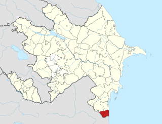
Astara District is one of the 66 districts of Azerbaijan. It is located in the south-east of the country and belongs to the Lankaran-Astara Economic Region. The district borders the districts of Lankaran, Lerik, as well as the Ardabil and Gilan provinces of Iran. Its capital and largest city is Astara. As of 2020, the district had a population of 110,000.

Jabrayil District is one of the 66 districts of Azerbaijan. It is located in the south-west of the country and belongs to the East Zangezur Economic Region. The district borders the districts of Khojavend, Fuzuli, Qubadli, Zangilan, and the Islamic Republic of Iran.

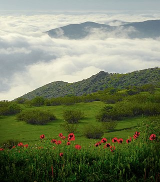
Zangilan District is one of the 66 districts of Azerbaijan. It is located in the south-west of the country and belongs to the East Zangezur Economic Region. The district borders the districts of Qubadli, Jabrayil, the Syunik Province of Armenia and the East Azerbaijan Province of Iran. Its capital and largest city is Zangilan. As of 2020, the district had a nominal population of 45,200.

Khojavend District is one of the 66 districts of Azerbaijan. It is located in the west of the country and belongs to the Karabakh Economic Region. The district borders the districts of Lachin, Shusha, Khojaly, Aghdam, Aghjabadi, Fuzuli, Jabrayil, and Qubadli. Its capital and largest city is Khojavend, however since the city is under Russian peacekeeping control, the current de facto capital is the town of Hadrut. As of 2020, the district had a nominal population of 44,100.

Qubadli is a city in Azerbaijan and the administrative centre of the Qubadli District. It is situated along the Vorotan (Bargushad) river.

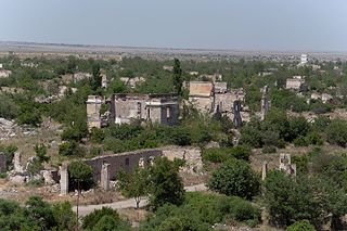
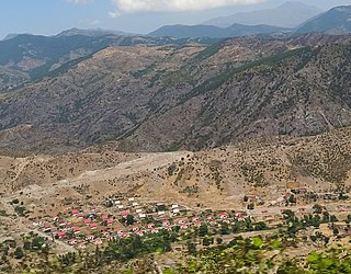
Zangilan is a city in Azerbaijan and the administrative centre of the Zangilan District. It is situated along the Voghji (Okhchuchay) river.
Karabakh is a geographic region in present-day southwestern Azerbaijan and eastern Armenia, extending from the highlands of the Lesser Caucasus down to the lowlands between the rivers Kura and Aras.
Nrnadzor is a village in the Meghri Municipality of the Syunik Province in Armenia, on the bank of the Aras River.
Gülablı, also known as Abdal-Gülablı, is a village in the Aghdam District of Azerbaijan.
Syrkhavend or Nor Ghazanchi is a village that is, de facto, in the Martakert Province of the breakaway Republic of Artsakh; de jure it is in the Agdam District of Azerbaijan, in the disputed region of Nagorno-Karabakh. The village had an Azerbaijani majority prior to their expulsion during the First Nagorno-Karabakh War.

Charektar is a village de facto in the Shahumyan Province of the breakaway Republic of Artsakh, de jure in the Kalbajar District of Azerbaijan, in the disputed region of Nagorno-Karabakh. The village had an Azerbaijani-majority population prior to their exodus during the First Nagorno-Karabakh War.
Zabukh or Aghavno is a village in the Lachin District of Azerbaijan. The village came under the control of the breakaway Republic of Artsakh after 1992 and was renamed Aghavno and settled by Armenians. Following the 2020 Nagorno-Karabakh war, Zabukh came under the control of the Russian peacekeeping forces in Nagorno-Karabakh. On 26 August 2022, Azerbaijan regained control of Zabukh along with other settlements located along the former route of the Lachin corridor, including Lachin and Sus.
Günəşli, is a village and municipality in the Lerik Rayon of Azerbaijan. It has a population of 1,022. The municipality consists of the villages of Günəşli and Babagil.

Xanlıq is a village in the Qubadli District of Azerbaijan. It is situated along the Hakari river.
Daşbulaq is a ghost village in the Kalbajar District of Azerbaijan.
Imar or Karamli is a village that is, de facto, in the Martakert Province of the breakaway Republic of Artsakh; de jure, it is in the Kalbajar District of Azerbaijan, in the disputed region of Nagorno-Karabakh. The village had an Azerbaijani-majority population prior to their expulsion during the Nagorno-Karabakh war.

Zandabad is a village in Owch Hacha Rural District of the Central District of Ahar County, East Azerbaijan province, Iran.
Ashnaabad is a village in Rowzeh Chay Rural District, in the Central District of Urmia County, West Azerbaijan Province, Iran. At the 2006 census, its population was 335, in 100 families. This village is populated by Azerbaijani Turks.