The transport network of the Russian Federation is one of the world's most extensive transport networks. The national web of roads, railways and airways stretches almost 7,700 km (4,800 mi) from Kaliningrad in the west to the Kamchatka Peninsula in the east, and major cities such as Moscow and Saint Petersburg are served by extensive rapid transit systems.

Bryansk is a city and the administrative center of Bryansk Oblast, Russia, situated on the River Desna, 379 kilometers (235 mi) southwest of Moscow. Population: 415,721 (2010 Census); 431,526 (2002 Census); 452,160 (1989 Census).

Gatchina is a town and the administrative center of Gatchinsky District in Leningrad Oblast, Russia. It lies 45 kilometers (28 mi) south of St. Petersburg, along the E95 highway leading to Pskov. Population: 92,937 (2010 Census); 88,420 (2002 Census); 79,714 (1989 Census).

Volkhov is an industrial town and the administrative center of Volkhovsky District in Leningrad Oblast, Russia, located on the river Volkhov 122 kilometers (76 mi) east of St. Petersburg. Population: 47,182 (2010 Census); 46,596 (2002 Census); 50,325 (1989 Census).

Khimki is a city in Moscow Oblast, Russia, 18.25 kilometres northwest of central Moscow.

The Moscow Automobile Ring Road, or MKAD (МКАД), is a ring road running predominantly on the city border of Moscow with a length of 108.9 km (67.7 mi) and 35 exits. It was completed in 1962. The speed limit is 100 km/h.

A subway, also known as an underpass, is a grade-separated pedestrian crossing which crosses underneath a road or railway in order to entirely separate pedestrians and cyclists from motor traffic or trains respectively.

The Third Ring Road, or The Third Ring, is a beltway around central Moscow, Russia, located between the Garden Ring in the city centre and the Moscow Ring Road (MKAD).

Mga is an urban locality in Kirovsky District of Leningrad Oblast, Russia. Population: 10,212 (2010 Census); 9,613 (2002 Census); 9,852 (1989 Census).

Leningradsky Prospekt, or Leningrad Avenue, is a major arterial avenue in Moscow, Russia. It continues the path of Tverskaya Street and 1st Tverskaya-Yamskaya Street north-west from Belorussky Rail Terminal, and changes the name once again to Leningrad Highway past the Sokol metro station. The Highway continues its way to Saint Petersburg via Tver.

Rail transport in Russia runs on one of the biggest railway networks in the world. Russian railways are the third longest by length and third by volume of freight hauled, after the railways of the United States and China. In overall density of operations /length of track, Russia is second only to China. Rail transport in Russia has been described as one of the economic wonders of the 19th, 20th, and 21st centuries.
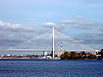
The Bolshoy Obukhovsky Bridge is the newest bridge across the Neva River in Saint Petersburg, Russia. It is the only bridge across the Neva which is not a drawbridge. One of the longest bridges in Russia, it is the first fixed bridge and largest bridge across the Neva. Of course it is the largest bridge in St. Petersburg by the size of the covered span. It is located in Nevsky District, in the middle stream of the Neva. It connects Obukhovskaya Oborony Avenue with the Oktyabrskaya embankment. It is a cable-stayed bridge; the steel wire ropes are the key element of the supporting construction. But what looks like a bridge is actually two identical twin bridges with opposite directions of movement along them. One is located upstream of the Neva (southern) and is for driving eastward, the other downstream (north) is for driving in a western direction.

Nikolskoye is a town in Tosnensky District of Leningrad Oblast, Russia, located on the Tosna River 40 kilometers (25 mi) southeast of the center of St. Petersburg. Population: 19,280 (2010 Census); 17,309 (2002 Census); 17,215 (1989 Census).
Siversky is an urban locality in Gatchinsky District of Leningrad Oblast, Russia, on the bank of the Oredezh River. Its population was 12,216 (2010 Census); 12,137 (2002 Census); 11,885 (1989 Census).

The Saint Petersburg Ring Road is a 142 km orbital freeway encircling Saint Petersburg, Russia. The city's only beltway, it is listed in the Russian road numbering system as federal public highway A-118.

The Russian route M8 "Kholmogory" or Yaroslavl highway, is a major trunk road that links Moscow to the Russian North in general and the sea harbour of Arkhangelsk in particular. The road runs north of Moscow across a distance of 1271 kilometres through Mytishchi, Pushkino, Sergiyev Posad, Pereslavl-Zalessky, Rostov the Great, Yaroslavl, Danilov, Gryazovets, Vologda, Kadnikov, Velsk, Kholmogory, and Arkhangelsk, ending up in the city of Severodvinsk. It passes Moscow, Vladimir, Yaroslavl, Vologda, and Arkhangelsk Oblasts.

Lomonosovsky District is an administrative and municipal district (raion), one of the seventeen in Leningrad Oblast, Russia. It is located in the west of the oblast and borders with Petrodvortsovy and Krasnoselsky Districts of the Federal city of Saint Petersburg in the east, Gatchinsky District in the southeast, Volosovsky District in the south, Kingiseppsky District in the southwest, and the city of oblast significance of Sosnovy Bor in the west. In the north, the district is bounded by the Gulf of Finland. The area of the district is 1,919 square kilometers (741 sq mi). Its administrative center is the town of Lomonosov. Population: 70,245 (2010 Census); 65,297 ; 66,104 (1989 Census).
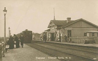
Gorskaya, is a railway station near Saint Petersburg, Russia. The station was opened on November 26, 1894, when the Primorskaya line was extended from Razdelnaya station to Sestroretsk.
Fornosovo is an urban locality in Tosnensky District of Leningrad Oblast, Russia, located on the Khennaya River southeast of the town of Pavlovsk. Municipally it is incorporated as Fornosovskoye Urban Settlement, one of the seven urban settlements in the district. Population: 6,408 (2010 Census); 4,866 (2002 Census); 2,774 (1989 Census).
Murino is a town in Vsevolozhsky District of Leningrad Oblast, Russia, located east of and immediately adjacent to the city of St. Petersburg. Formerly a settlement, it was granted a town status on 27 March 2019. The population estimates of Murino are about 50 thousands.