Related Research Articles

Worcestershire is a ceremonial county in the West Midlands of England. It is bordered by Shropshire, Staffordshire, and the West Midlands county to the north, Warwickshire to the east, Gloucestershire to the south, and Herefordshire to the west. The city of Worcester is the largest settlement and the county town.

Gloucestershire is a ceremonial county in South West England. It is bordered by Herefordshire to the north-west, Worcestershire to the north, Warwickshire to the north-east, Oxfordshire to the east, Wiltshire to the south, Bristol and Somerset to the south-west, and the Welsh county of Monmouthshire to the west. The city of Gloucester is the largest settlement and the county town.

Dymock is a village and civil parish in the Forest of Dean district of Gloucestershire, England, about four miles south of Ledbury. In 2014 the parish had an estimated population of 1,205.

The Herefordshire and Gloucestershire Canal is a canal in the west of England, which ran from Hereford to Gloucester, where it linked to the River Severn. It was opened in two phases in 1798 and 1845, and closed in 1881, when the southern section was used for the course of the Ledbury and Gloucester Railway. It is the subject of an active restoration scheme.

Newent is a market town and civil parish in the Forest of Dean in Gloucestershire, England. The town is 11 miles (18 km) north-west of Gloucester. Its population was 5,073 at the 2001 census, rising to 5,207 in 2011, The population was 6,777 at the 2021 Census. Once a medieval market and fair town, its site had been settled at least since Roman times. The first written record of it appears in the 1086 Domesday Book.

Forest of Dean is a local government district in west Gloucestershire, England, named after the Forest of Dean. Its council is based in Coleford. Other towns and villages in the district include Blakeney, Cinderford, Drybrook, English Bicknor, Huntley, Littledean, Longhope, Lydbrook, Lydney, Mitcheldean, Newnham and Newent.
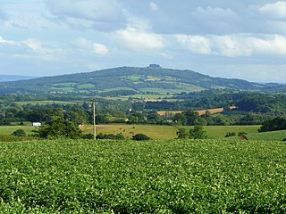
May Hill is a prominent English hill between Gloucester and Ross-on-Wye. Its summit, on the western edge of Gloucestershire and its northern slopes in Herefordshire, is distinguishable by a clump of trees on its summit, which forms an official Site of Special Scientific Interest. It is reached by three public footpaths, two as parts of the Gloucestershire Way and Wysis Way.

Forest of Dean is a constituency in Gloucestershire represented in the House of Commons of the UK Parliament since 2005 by Mark Harper, a Conservative who has served as Secretary of State for Transport since 2022.

Aston Ingham is a village in south-eastern Herefordshire, England, near Newent and about 7 miles (11 km) east of Ross-on-Wye. The population of the village at the 2011 census was 398. There is a church, dedicated to St John the Baptist, which has been a Grade II* listed building since 17 March 1987.
Alvington is a village and civil parish in the Forest of Dean in Gloucestershire, England, situated on the A48 road, six miles north-east of Chepstow in Wales. The parish had a total population of 506 at the 2011 census.

Mitcheldean is a market town in the Forest of Dean in Gloucestershire, England.

Gorsley is a small village in the Forest of Dean district of Gloucestershire, England, forming part of the civil parish of Gorsley and Kilcot. Nearby Gorsley Common and Little Gorsley are both in Herefordshire.
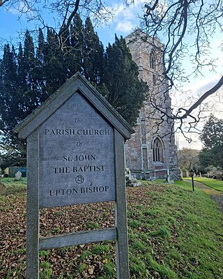
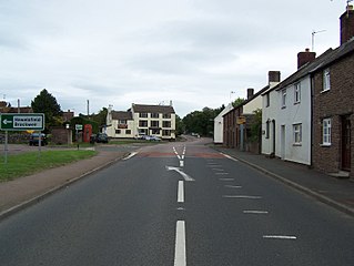
Upton Bishop is a small village in Herefordshire, England. The population of the village at the 2011 census was 602.

Redmarley D'Abitot is a civil parish and village in the Forest of Dean district, Gloucestershire, South West England. In addition to the village of Redmarley, the civil parish also includes the settlements of Lowbands, Haw Cross, Playley Green, Kings Green and Durbridge. At the 2001 census the parish had a population of 705, increasing to 756 at the 2011 census.
The GL postcode area, also known as the Gloucester postcode area, is a group of 27 postcode districts in south-west England and a very small part of south-east Wales, within 28 post towns. These cover most of Gloucestershire, including Gloucester, Cheltenham, Stroud, Cirencester, Tewkesbury, Badminton, Berkeley, Blakeney, Chipping Campden, Cinderford, Coleford, Drybrook, Dursley, Dymock, Fairford, Lechlade, Longhope, Lydbrook, Lydney, Mitcheldean, Moreton-in-Marsh, Newent, Newnham, Ruardean, Stonehouse, Tetbury, Westbury-on-Severn and Wotton-under-Edge. The area also covers very small parts of Herefordshire, Worcestershire, Warwickshire, Oxfordshire and Wiltshire, while the GL16 district extends across the Welsh border to cover a very small part of Monmouthshire.

Rudford is a village and former civil parish, now in the parish of Rudford and Highleadon, in the Forest of Dean district, in the county of Gloucestershire, England. It is located approximately 4 miles (6 km) north-west of Gloucester and 5 miles (8 km) south-east of Newent. The local church is dedicated to St Mary. In 1931 the parish had a population of 114.

Cliffords Mesne is an English village in Gloucestershire, two miles south-west of the town of Newent. It became the home of the autobiographical author Winifred Foley from the mid-1970s, after the success of her first book of Gloucestershire reminiscences, A Child in the Forest.

Newent railway station served the town of Newent in Gloucestershire, England.

Gloucestershire Victoria County History is an encyclopaedic history of the county of Gloucestershire in England. It forms part of the overall Victoria County History of England founded in 1899 in honour of Queen Victoria. With twelve volumes published in the series A History of the County of Gloucestershire, the Gloucestershire Victoria County History is about halfway through its history of all the parishes in the county. Ten volumes have been published to date, and a further four volumes are in preparation.

Oxenhall is a village and civil parish 10 miles (16 km) north west of Gloucester, in the Forest of Dean district, in the county of Gloucestershire, England. In 2011 the parish had a population of 243. The parish touches Dymock, Gorsley and Kilcot, Kempley, Newent and Upton Bishop. Oxenhall has a parish meeting.
References
- ↑ "Civil parish population 2011". Archived from the original on 2 April 2015. Retrieved 28 March 2015.
- ↑ "Gorsley & Kilcot Parish Council". Archived from the original on 11 July 2011 – via Internet Archive.
- ↑ ""Kilcot Inn" at kilcotinn.com". Archived from the original on 10 November 2012. Retrieved 31 December 2012.
- ↑ "Full text of "Place-names of Gloucestershire; a handbook" by Welbore St. Clair Baddeley (1913) at archive.org
- ↑ "Origins of the Place-name Hawkesbury" at awkesburylocalhistorysociety.co.uk