County Leitrim is a county in the Republic of Ireland. It is in the province of Connacht and is part of the Border Region. It is named after the village of Leitrim. Leitrim County Council is the local authority for the county, which had a population of 32,044 according to the 2016 census. The county encompasses the historic Gaelic territory of West Breffny (Bréifne) corresponding to the northern part of the county, and Muintir Eolais or Conmaicne Réin, corresponding to the southern part.
Bloomington is a village in Franklin County, Nebraska, United States. The population was 103 at the 2010 census.
Pine Knoll Shores is a town in Carteret County, North Carolina, United States. The population was 1,339 at the 2010 census. One of North Carolina's state aquariums is located here.
Ballinamore is a small town in County Leitrim, Ireland.
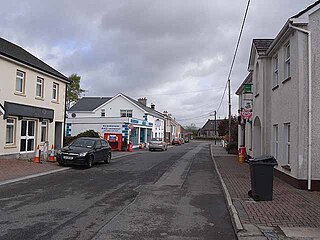
Mohill is a town in County Leitrim, Ireland. The town of Carrick-on-Shannon is approximately 16 km (10 miles) away.
Cloone is a village in County Leitrim, Ireland. The village is located in the south of the county, just off the R201 regional road; its nearest town is Mohill. Its name is an anglicised version of the Irish-language word cluain, meaning 'meadow'.
Artigarvan is a village and townland in County Tyrone, Northern Ireland. It is 3 miles from Strabane and 4 miles from Dunnamanagh, within the Strabane District Council area. It is called Airtigarvan in Ulster-Scots.
Boyerstown is a small townland in County Meath, Ireland. It is located off the N51 National secondary road 5 km southwest of Navan
Kilnamona is a village and a civil parish in County Clare, Ireland. It is situated north-west of Ennis.
Tubber is a village in the north of County Clare, Ireland.
The R202 road is a regional road in Ireland linking Dromod in County Leitrim to Swanlinbar in County Cavan.
Newtowngore or Newtown Gore, known before the Plantations of Ireland as Ducarrick, is a village on the R199 regional road in County Leitrim, in the north of the parish of Carrigallen.
The United States Border Patrol operates 71 traffic checkpoints, including 33 permanent traffic checkpoints, near the Mexico–United States border. The stated primary purpose of these inspection stations is to deter illegal immigration and smuggling activities. After the September 11 attacks in 2001, they took on the additional role of terrorism deterrence. These checkpoints are located between 25 and 75 miles of the Mexico–United States border along major U.S. highways; near the southern border of the contiguous United States. Their situation at interior locations allow them to deter illegal activities that may have bypassed official border crossings along the frontier. The checkpoints are divided among nine Border Patrol sectors. There are a number of these checkpoints near the northern border of the contiguous U.S. as well, within 100 miles (160 km) of the Canada–U.S. border.
Kilbride is a townland within the parish of Tramore in County Waterford, Ireland. Kilbride is located about 3 miles (4.8 km) from Tramore town and 4 miles (6.4 km) from Waterford. It is split into two sections: Kilbride North and Kilbride South.
Breandrum is a townland 4 miles from the town of Mohill in County Leitrim, Ireland. It is situated to the north-west of the town, along the L3052 road to Keshcarrigan. Breandrum Bridge is an old three-arched stone bridge spanning the River Eslin, a tributary of the River Shannon.
Bornacoola is an Ecclesiastical parish in the Roman Catholic Diocese of Ardagh and Clonmacnoise, Ireland. It is located at the southern extremity of County Leitrim in the civil parish of Mohill. Some of its townlands lie in neighbouring County Longford. The nearest large towns are Longford and Carrick-on-Shannon.
Magheracross is a townland and civil parish in County Fermanagh, Northern Ireland. It extends in area from just north of Enniskillen to the Border with County Tyrone. There is also a small enclave in County Tyrone.
Carrigallen is a barony in County Leitrim, Republic of Ireland.
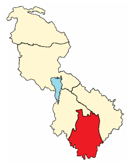
The barony of Mohill is an ancient barony in County Leitrim, Republic of Ireland.
The Owenmore River rises in the Cuilcagh Mountains, in the townland of Dunmakeever, civil parish of Kinawley, Roman Catholic parish of Glangevlin, Barony of Tullyhaw, County Cavan. It then flows in a north-west direction and ends in the River Shannon in Gowlat townland. It has a fish population of brown trout. The Book of Magauran, dating to the 1350s, mentions an Abhainn Mór but from the geographical description it probably means the Yellow River at Ballinamore rather than the Owenmore River. What cannot be disputed is the Owenmore River's claim to be the "true" headwaters of the River Shannon with the infant Shannon just a minor tributary of it. The Owenmore flows west for 14.5 km through the valley of Glangevlin before joining the Shannon about 3 km below the Shannon Pot at Lugnashinna, thus adding 11 km to the Shannon's overall length, taking it from 360 km to 372 km.
This page is based on this Wikipedia article Text is available under the CC BY-SA 4.0 license; additional terms may apply. Images, videos and audio are available under their respective licenses.