
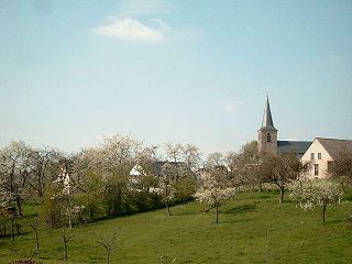
Gotem is a small town in the Limburg province of Belgium and is part of the municipality of Borgloon.
Gotem is a small town in the Limburg province of Belgium and is part of the municipality of Borgloon.
Population: 282 (1 January 2002) [1]
Postal code: 3840
Coordinates: 50° 47' 60" N, 5° 17' 60" E
Elevation: 58 meters

Limburg is a province in Belgium. It is the easternmost of the five Dutch-speaking provinces that together form the Region of Flanders, one of the three main political and cultural sub-divisions of modern Belgium.

The Duchy of Limburg or Limbourg was an imperial estate of the Holy Roman Empire. Much of the area of the duchy is today located within Liège Province of Belgium, with a small portion in the municipality of Voeren, an exclave of the neighbouring Limburg Province. Its chief town was Limbourg-sur-Vesdre, in today's Liège Province.
Veldwezelt-Hezerwater is a Palaeolithic archaeological site in the municipality of Lanaken in the province of Limburg, Belgium.

The Campine or De Kempen is a natural region situated chiefly in north-eastern Belgium and parts of the south-eastern Netherlands which once consisted mainly of extensive moors, tracts of sandy heath, and wetlands. It encompasses a large northern and eastern portion of Antwerp Province and adjacent parts of Limburg in Belgium, as well as portions of the Dutch province of North Brabant and Dutch Limburg around Weert.
The Hesbaye, or Haspengouw is a traditional cultural and geophysical region in eastern Belgium. It is a loamy plateau region which forms a watershed between the Meuse and Scheldt drainage basins. It has been one of the main agricultural regions in what is now Belgium since before Roman times, and specifically named in records since the Middle Ages, when it was an important Frankish pagus or gau, called Hasbania in medieval Latin.

Val-Dieu Abbey is a former Cistercian monastery in Wallonia in the Berwinne valley near Aubel in the Land of Herve.
Borgharen is a town in the Dutch province of Limburg. It is a part of the municipality of Maastricht, and lies about 3 km north of Maastricht. Until 1970, it was a separate municipality.

Franchimont Castle is a medieval castle in the municipality of Theux, Liège Province, Wallonia, Belgium. It sits at the western end of a small hill 2 kilometres (1.2 mi) south of the village of Theux, a sub-municipality.
Sint Pieter is a neighbourhood in the city of Maastricht, in the Dutch province of Limburg. It is located on the western bank of the river Meuse, in the south of the city, and borders Belgium. It is a relatively affluent neighbourhood.
Winneweer is a small village in the municipalities of Eemsdelta and Groningen in the Dutch province of Groningen.

Kasteel Lagendal is a country house in Lummen, in the province of Limburg, Belgium. It was built in 1850 in a vernacular late classical style as a shooting box commissioned by Paul Jacobs-Stellingwerff of Hasselt. Its name comes from its site on the longest point of the Lummen. Until 2005, renamed Kasteel Saint-Paul, it housed an up-market French restaurant.

The Diocese of Hasselt is a Latin Church ecclesiastical territory or diocese of the Catholic Church in Belgium. Comprising the whole of Belgian Limburg, the diocese was erected in 1967, split from the Diocese of Liège. It is a suffragan in the ecclesiastical province of the metropolitan Archdiocese of Mechelen-Brussels. The cathedra is found within the St. Quentin Cathedral, Hasselt.

The Redemptiedorpen are a group of small villages north of Liège, Belgium. Their ownership was disputed between the United Provinces and the Duchy of Brabant since the 17th century. The areas retained independence, with the condition that they pay taxes to both powers. In practice, they were closely linked to the tweeherigheid of Maastricht.

The Duchy of Limburg was a European polity created in 1839 from parts of the Dutch Province of Limburg as a result of the Treaty of London. Its territory was the part of Limburg that remained Dutch, with the exceptions of the cities of Maastricht and Venlo. The duchy was simultaneously a province of the Kingdom of the Netherlands and a member of the German Confederation.

Diepenbeek Castle is a castle in Diepenbeek near Hasselt in the province of Limburg, Belgium. The building consists of a 15th-century keep with a 17th-century main block. It was once the establishment of the steward of the nearby Commandery of Alden Biesen, whence the alternative name.

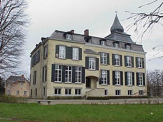
Hasselbroek Castle, also Hasselbrouck Castle is a 17th-century country house in Hasselbroek, in Jeuk, a part of the municipality of Gingelom, province of Limburg, Belgium.
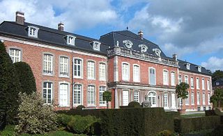
Heks Castle is a château in the village of Heks in the municipality of Heers, province of Limburg, Belgium.
Ommerstein Castle is a castle in the village of Rotem in the municipality of Dilsen-Stokkem, province of Limburg, Belgium.
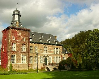
Rullingen Castle is a castle in Kuttekoven in the municipality of Borgloon, province of Limburg, Belgium. Its situation in the valley of the Herk is very scenic.
Degeres is a village located in Zhambyl District, Almaty Region, Kazakhstan.
Coordinates: 50°48′15″N05°18′36″E / 50.80417°N 5.31000°E
| | This Belgian Limburg location article is a stub. You can help Wikipedia by expanding it. |