Gould Park

Last updated

Gould Park is a public park located in Santa Barbara, California. It was a gift from Charles W. and Clara H. Gould in June 1926. [1] This 360+ acre park has not been developed by the City since its acquisition.

Park area of open space used for recreation or conservation

A park is an area of natural, semi-natural or planted space set aside for human enjoyment and recreation or for the protection of wildlife or natural habitats. Urban parks are green spaces set aside for recreation inside towns and cities. National parks and Country parks are green spaces used for recreation in the countryside. State parks and Provincial parks are administered by sub-national government states and agencies. Parks may consist of grassy areas, rocks, soil and trees, but may also contain buildings and other artifacts such as monuments, fountains or playground structures. Many parks have fields for playing sports such as soccer, baseball and football, and paved areas for games such as basketball. Many parks have trails for walking, biking and other activities. Some parks are built adjacent to bodies of water or watercourses and may comprise a beach or boat dock area. Urban parks often have benches for sitting and may contain picnic tables and barbecue grills.

Santa Barbara, California City in California, United States

Santa Barbara is the county seat of Santa Barbara County in the U.S. state of California. Situated on a south-facing section of coastline, the longest such section on the West Coast of the United States, the city lies between the steeply rising Santa Ynez Mountains and the Pacific Ocean. Santa Barbara's climate is often described as Mediterranean, and the city has been promoted as the "American Riviera". As of 2014, the city had an estimated population of 91,196, up from 88,410 in 2010, making it the second most populous city in the county after Santa Maria. The contiguous urban area, which includes the cities of Goleta and Carpinteria, along with the unincorporated regions of Isla Vista, Montecito, Mission Canyon, Hope Ranch, Summerland, and others, has an approximate population of 220,000. The population of the entire county in 2010 was 423,895.

California State of the United States of America

California is a state in the Pacific Region of the United States. With 39.6 million residents, California is the most populous U.S. state and the third-largest by area. The state capital is Sacramento. The Greater Los Angeles Area and the San Francisco Bay Area are the nation's second and fifth most populous urban regions, with 18.7 million and 9.7 million residents respectively. Los Angeles is California's most populous city, and the country's second most populous, after New York City. California also has the nation's most populous county, Los Angeles County, and its largest county by area, San Bernardino County. The City and County of San Francisco is both the country's second-most densely populated major city after New York City and the fifth-most densely populated county, behind only four of the five New York City boroughs.

In 1932 the Southern California Edison company was permitted to construct and maintain a transmission line over the north end of the park. In December of the same year, the Park Commission discussed developing the land for recreational use, however the idea was dropped because only a small part of it was usable. [1]

Southern California Edison electrical utility in Southern California, USA

Southern California Edison, the largest subsidiary of Edison International, is the primary electricity supply company for much of Southern California. It provides 14 million people with electricity across a service territory of approximately 50,000 square miles. However, the Los Angeles Department of Water and Power, San Diego Gas & Electric, Imperial Irrigation District, and some smaller municipal utilities serve substantial portions of the southern California territory. The northern part of the state is generally served by the Pacific Gas & Electric Company of San Francisco.
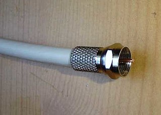
Transmission line specialized cable or other structure designed to carry alternating current of radio frequency

In radio-frequency engineering, a transmission line is a specialized cable or other structure designed to conduct alternating current of radio frequency, that is, currents with a frequency high enough that their wave nature must be taken into account. Transmission lines are used for purposes such as connecting radio transmitters and receivers with their antennas, distributing cable television signals, trunklines routing calls between telephone switching centres, computer network connections and high speed computer data buses.

Related Research Articles

Santa Cruz Island island in the United States of America

Santa Cruz Island is the largest of the eight islands in the Channel Islands and also the largest island in California, located off the coast of California. The island, in the northern group of the Channel Islands, is 22 miles (35 km) long and from 2 to 6 miles wide with an area of 61,764.6 acres (249.952 km2). Santa Cruz Island is located within Santa Barbara County, California. The coastline has steep cliffs, gigantic sea caves, coves, and sandy beaches. Defined by the United States Census Bureau as Block 3000, Block Group 3, Census Tract 29.10 of Santa Barbara County, the 2000 census showed an official population of two persons. The highest peak is Devils Peak, at 2450+ feet. It was the largest privately owned island off the continental United States but is currently jointly owned by the National Park Service (24%), and the Nature Conservancy (76%).

Alice Keck Park Memorial Garden

Alice Keck Park Memorial Garden is a park located in Santa Barbara, California. It consists of one entire city block, bounded by Santa Barbara, Micheltorena, Garden and Arrellaga Streets. It is across Santa Barbara Street from the Unitarian Society of Santa Barbara, and across Micheltorena Street from Alameda Park.

The Santa Barbara & Ventura Colleges of Law is a regionally accredited non-profit law school located in Santa Barbara and Ventura, California.

Parma Park is a park located in Santa Barbara, California.

Elings Park is a 230-acre (0.93 km2) non-profit park located in Santa Barbara, California east of Las Positas Road and south of U.S. Highway 101. It is the largest privately funded park in America. The park consists of sports fields, hiking and biking trails, playgrounds, wedding/special event venues, and landscaped walkways. The park is a hub for mountain biking, youth sports, paragliding, and other outdoor activities. Elings Park International Raceway is the only dedicated radio control (R/C) off-road course in Santa Barbara and Elings Park BMX Raceway is the only dedicated BMX track in Santa Barbara as well.

Douglas Family Preserve

The Douglas Family Preserve is a public park in Santa Barbara, California. The Preserve is located on the mesa above Arroyo Burro Beach. The property spans 70 acres (280,000 m2) of undeveloped ocean-front land, and represents the largest area of coastal open space within the city limits of Santa Barbara.

KRAZ country music radio station in Santa Ynez, California, United States

KRAZ is a commercial FM radio station which is licensed to Santa Ynez, California and broadcasts to the Santa Barbara and Santa Ynez, California areas. The station is owned by Knight Broadcasting Inc. and its studios are located in Santa Ynez.

Alameda Park

Alameda Park located in Santa Barbara, California, in the U.S., adjoining Alice Keck Park Memorial Gardens, is the location for many citywide celebrations, including Summer Solstice. It is also one of the city's oldest parks.

Skofield Park

Skofield Park is a 35 acres (140,000 m2) natural open space preserve and city park located within Santa Barbara, California. Rattlesnake Canyon Park is located nearby, with both in the "front country" of the Santa Ynez Mountains.

Andree Clark Bird Refuge, a 42-acre (170,000 m2) saltwater marsh is one of the largest wildlife refuges in Santa Barbara County, California, United States. The refuge has a 29-acre (120,000 m2) freshwater/brackish lake, that is an artificially modified estuary, which drains through East Beach into the Pacific Ocean.

De La Guerra Plaza is a small park type area in downtown Santa Barbara, California, USA, located right next to the Santa Barbara News-Press offices. It is best known for the activities that take place there during Santa Barbara's annual Fiesta in early August. There are booths, musical performances and lots of festivities for the downtown area in De La Guerra Plaza. In the 1950s, there was a glass blowing booth where children could buy and take home glass ornaments as souvenirs.

West beach is in Santa Barbara, California. It is home to Santa Barbara's New Years and 4th of July Fireworks shows.

Moreton Bay Fig Tree (Santa Barbara, California)

Santa Barbara's Moreton Bay Fig Tree located in Santa Barbara, California is believed to be the largest Ficus macrophylla in the United States.

Santa Barbara Library library

The Santa Barbara Public Library is the public library system of Santa Barbara, California.

Mussel Shoals is a coastal unincorporated community in Ventura County, California, between Ventura and the Santa Barbara County city of Carpinteria.

Carpinteria Tar Pits

The Carpinteria Tar Pits are a series of natural asphalt lakes situated in the southern part of Santa Barbara County in southern California.

The Santa Barbara International Marathon and Half Marathon is a road race in Southern California. The race was first run in 1965 and was one of the first marathons in California. Since Santa Barbara itself is a popular tourist destination, it is also becoming a popular destination marathon. The point-to-point marathon course currently start at Dos Pueblos High School in Goleta and finish at Santa Barbara City College in Santa Barbara, California. The marathon race can be used to obtain a qualifying time for the Boston Marathon.

Santa Barbara Fire Department

The Santa Barbara City Fire Department (SBFD) is the agency that provides fire protection and basic life support (BLS) emergency medical services exclusively for the city of Santa Barbara. Not to be confused Santa Barbara County Fire Department.

Our Lady of Sorrows Church (Santa Barbara, California) Church in California, United States

Our Lady of Sorrows Church is a Catholic church within the City of Santa Barbara, California in the United States that was built in 1929. The Church was listed as a designated landmark of the City of Santa Barbara on May 17, 2016.

Arroyo Burro or Arroyo Burro Creek is a stream in Santa Barbara County, California.

References

  1. 1 2 [Days, M.L. (1977). Histories of individual parks Santa Barbara California. Santa Barbara, CA: City Planning Committee.]

Coordinates: 34°27′55″N119°39′05″W / 34.465195°N 119.6513649°W / 34.465195; -119.6513649

Geographic coordinate system Coordinate system

A geographic coordinate system is a coordinate system that enables every location on Earth to be specified by a set of numbers, letters or symbols. The coordinates are often chosen such that one of the numbers represents a vertical position and two or three of the numbers represent a horizontal position; alternatively, a geographic position may be expressed in a combined three-dimensional Cartesian vector. A common choice of coordinates is latitude, longitude and elevation. To specify a location on a plane requires a map projection.