Erode District is one of the 38 districts in the south Indian state of Tamil Nadu. It was the largest district by area in the state before the formation of Tirupur district in 2009 and is the third largest by area, as of 2024. The headquarters of the district is Erode. The district is divided into two revenue divisions, Erode and Gobichettipalayam, and is further subdivided into 10 taluks.

Kovaipudur is a large township at the foothills of the Western Ghats, located in the City of Coimbatore, Tamil Nadu, India. The Regional Transport Office (RTO) of Coimbatore West is located at Kovaipudur. People represent this city as Little Ooty due to its cool climate and serene environment, and was set up sometime in late seventies. Today this township has about 7500 families, three arts colleges, one engineering college, a polytechnic and a handful of schools. Kovaipudur has come under the Corporation of Coimbatore and became one of the average localities in Coimbatore.

Wellington is a town in the Nilgiris District of the Indian state of Tamil Nadu, located at three kilometres to the north of Coonoor on the NH-181. The town includes a Wellington Bazaar, and the Wellington Cantonment. The Wellington Cantonment is home to The Madras Regimental Centre (MRC) and The Defence Services Staff College (DSSC). The Nilgiri passenger train passes through Wellington, which also has a railway station.
Chennimalai is a town in Erode district, Tamil Nadu, India. It is situated away from Erode of about 28kms., Chenni which means Chief and Malai means Hill. It is popularly known as the 'Handloom Town'.

Chikkodi is a town, taluka and one of three Subdivisional headquarter, in the Belagavi district of Karnataka, India. Chikodi, Athani, Hukkeri, Raybag, Nipani and Kagwad are the taluks that come under Chikodi Subdivision. It is 75 kilometers from the city of Belgaum, 65 kilometers from Kolhapur, 51 kilometers from Miraj, 160 kilometers from Hubli, and 570 kilometers from the capital of Karnataka state, Bangalore. Chikodi has many district level offices but it is not designated as a district by the Government of Karnataka. It is one of the major cities that lies in the border between Karnataka and Maharashtra states.
Chinnavedampatti a suburb of Coimbatore City in the state of Tamil Nadu, India. It is located on the North-east direction, which comes under the Coimbatore Corporation.

Dharapuram is a town situated along the banks of Amaravati River in Tiruppur district in the Indian state of Tamil Nadu. Dharapuram is one of the oldest towns in South India and was the capital of Kongu Nadu under the Cheras, Western Ganga Dynasty and later Kongu Cholas, at which time it was known as Viradapuram. Amaravathi River flows through the town. As of 2011, the town had a population of 67,007. The city houses famous temples including Agatheeswarar Temple, Kaadu Hanumanthasamy temple and many others.

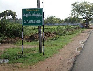
Karambakkudi is a panchayat town as well as Taluk in Pudukkottai district in the Indian state of Tamil Nadu. Karambakkudi is located about 40 km from Thanjavur and 40 km from Pudukkottai. This town is located on the border of the Thanjavur and Pudukkottai district in Tamil Nadu. The opinion of the people of this area is that this area should become an assembly constituency very soon, Here all higher secondary schools and Art's college is there.This area is covered by Delta Region.
Kattumannarkoil is a panchayat town and taluk headquarters in Cuddalore district in the Indian state of Tamil Nadu. Kattumannarkoil Town Panchayat constituted in 1892. The town is coming under the administrative territory of Cuddalore District. The town extends over an area of 19.425 km2. The town is situated along 25 km South West of Chidambaram and lies on the Chidambaram - Coimbatore Highway and 25 km East of Srimushnam and a similar distance north-east of Gangaikonda Cholapuram. The Place is considered as the birthplace of one of the great Vaishnavate Acharya Nathamuni and Yamunacharya. As Lord Vishnu came here as King ‘Mannan’ to hold the hand of Mahalakshmi; and later asked Nathamunigal to share the Divya Prabandham and the Vaishnava Sampradayam to the world at large, he was referred to as ‘ Kattum – Mannan – Aanaar’ and the town later became Kattu Mannar. The place historic name was Veeranarayanapuram.
Mecheri is a town in Mettur taluk, Salem district, Tamil Nadu, India.
Ayyam Pudhur village, Nagadevam Palayam post, is a small village of less than 150 inhabitants, situated in the Gobi taluk, Erode district in Tamil Nadu. It is located approximately 10 km (6 mi) from Gobichettipalayam. The nearest big village is Vellan Kovil.
PeriyaKuravan Palayam village, Nagadevam Palayam post, also known as Velliankattu Pudur, is a small village of less than 150 inhabitants, situated in the Gobi taluk, Erode district in Tamil Nadu, India. It has one government library. The nearest village is Ayyam Pudhur. It is situated near to Gobichettipalayam at about 10 km. Agriculture is the primary occupation, with coconuts, rice, Turmeric and sugarcane being the main crops grown.

Pakistan's climate varies from a continental type of climate in the north (Gilgit-Baltistan,Kashmir,KPK), a mountainous dry climate in the west (Baluchistan), a wet climate in the East (Punjab) an arid climate in the Thar Desert, to a tropical climate in the southeast (Sindh), characterized by extreme variations in temperature, both seasonally and daily, because it is located on a great landmass barely north of the Tropic of Cancer.

Somayanur village is part of 22 Nanjundapuram Panchayat located in Coimbatore, Tamil Nadu, India.
Athiyur is a village in the Kumbakonam taluk of Thanjavur district, Tamil Nadu India. It is located 44 km north of the district headquarters in Thanjavur. Agriculture is the basis of the economy. Almost every job and/or occupation is in some way or another agriculturally related.

Thurakapalem is a village located in Muppalla Mandal of Guntur district in the state of Andhra Pradesh, India This village comes under the jurisdiction of Sattenapalli Assembly Constituency and Narasaraopet Parliamentary Constituency.
Kalikkavalasu is a village near Chennimalai in Erode district of Tamil Nadu, India. The village is an industrial area with many dyeing units and handlooms. The local temples are Pillayar Kovil, Karuppana Swamy Kovil, and Maduraiveeran temple.

Karipatti is one of the most developed villages in the Salem district of Tamil Nadu, India. It is located 15 km towards East from District headquarters Salem. 6 km from Ayodhiyapattinam. 308 km from State capital Chennai. Karipatti Pin code is 636106 and postal head office is Karipatti. Tamil is the Local Language here. National Highway 68 is pass through this village. It is one of the important highways in Tamil Nadu which is connecting the district headquarters Salem to the state headquarters Chennai. A Karipatti Police Station is located in this village.
Jhuruli is a village in Basirhat II CD Block in Basirhat subdivision of North 24 Parganas district in the Indian state of West Bengal.

Tiruppur or Tirupur ( ), is a city in the Indian state of Tamil Nadu. It is located on the banks of the Noyyal river and is the fourth largest urban agglomeration in Tamil Nadu. It is the administrative capital of Tiruppur district and is administered by the Tiruppur Municipal Corporation which was established in 2008.


