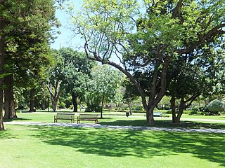
Government House Lake is a saline lake on Rottnest Island in Western Australia. It is partly reclaimed on its southern shore, for the Rottnest Island Airport. Adjacent lakes are Pearse Lakes to the west, Serpentine Lake to the south west, and Herschell and Garden Lakes to the north.
A salt lake or saline lake is a landlocked body of water that has a concentration of salts and other dissolved minerals significantly higher than most lakes. In some cases, salt lakes have a higher concentration of salt than sea water; such lakes can also be termed hypersaline lakes. An alkalic salt lake that has a high content of carbonate is sometimes termed a soda lake.
Rottnest Island is an island off the coast of Western Australia, located 18 kilometres (11 mi) west of Fremantle. A sandy, low-lying island formed on a base of aeolianite limestone, Rottnest is an A-class reserve, the highest level of protection afforded to public land. Together with Garden Island, Rottnest Island is a remnant of Pleistocene dune ridges.
Western Australia is a state occupying the entire western third of Australia. It is bounded by the Indian Ocean to the north and west, and the Southern Ocean to the south, the Northern Territory to the north-east, and South Australia to the south-east. Western Australia is Australia's largest state, with a total land area of 2,529,875 square kilometres, and the second-largest country subdivision in the world, surpassed only by Russia's Sakha Republic. The state has about 2.6 million inhabitants – around 11 percent of the national total – of whom the vast majority live in the south-west corner, 79 per cent of the population living in the Perth area, leaving the remainder of the state sparsely populated.
Government House Lake is a salt lake on Rottnest Island.
The Government House Lake, and the other lakes of Rottnest are often mentioned in passing, in anecdotal reminiscences about the island.[1]
Various features have been constructed since European settlement of the Island in the 1800s. In the 1930s a stone jetty was constructed (also identified as "old bathing groyne" on recent maps).[2] Apart from the airport it also had a war time railway, and recent tourist railway run south of its shore.
A geographic coordinate system is a coordinate system that enables every location on Earth to be specified by a set of numbers, letters or symbols. The coordinates are often chosen such that one of the numbers represents a vertical position and two or three of the numbers represent a horizontal position; alternatively, a geographic position may be expressed in a combined three-dimensional Cartesian vector. A common choice of coordinates is latitude, longitude and elevation. To specify a location on a plane requires a map projection.
This page is based on this Wikipedia article Text is available under the CC BY-SA 4.0 license; additional terms may apply. Images, videos and audio are available under their respective licenses.
Related Research Articles
Gage Roads is an area in the outer harbour area of Fremantle Harbour in the Indian Ocean offshore from Fremantle, Western Australia.
Boyanup is a town on the South Western Highway in the South West agricultural region, 195 km south of Perth and 18 km south-east of Bunbury, Western Australia. The town is located on the Preston River.
Matilda Bay or Crawley Bay is a natural bay in the Swan River in Western Australia, adjacent to the Perth suburb of Crawley. It extends from Pelican Point to Mounts Bay Road below Kings Park.
Barrack Square is an open public square on the foreshore of Perth Water on the Swan River, located at the southern end of Barrack Street near the central business district of Perth, Western Australia.
A coffee palace was an often large and elaborate residential hotel that did not serve alcohol, most of which were built in Australia in the late 19th century. 'Temperance hotels' were first established in the UK in the 1850s to provide an alcohol-free alternative to corner pubs and residential hotels, and by the 1870s they could be found in every town and city, some quite large and elaborate. In the late 1870s the idea caught on in Australia, where the appellation 'coffee palace' was almost universal, and dozens were built in the 1880s and early 1890s, including some of the largest hotels in the country. Due to the depression of the later 1890s, some became ordinary hotels and others were converted to different uses. The name continued to be applied to smaller residential hotels and guest houses in the early 20th century, until the trend died out.
Stirling Gardens is a small public park in Perth, Western Australia.
Forrest Highway is a 95-kilometre-long (59 mi) highway in Western Australia's Peel and South West regions, extending Perth's Kwinana Freeway from east of Mandurah down to Bunbury. Old Coast Road was the original Mandurah–Bunbury route, dating back to the 1840s. Part of that road, and the Australind Bypass around Australind and Eaton, were subsumed by Forrest Highway. The highway begins at Kwinana Freeway's southern terminus in Ravenswood, continues around the Peel Inlet to Lake Clifton, and heads south to finish at Bunbury's Eelup Roundabout. There are a number of at-grade intersections with minor roads in the shires of Murray, Waroona, and Harvey including Greenlands Road and Old Bunbury Road, both of which connect to South Western Highway near Pinjarra.
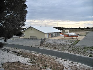
Rottnest Island Airport is a small airport for light aircraft, situated about 800 m (2,600 ft) from the main settlement at Thomson Bay, Rottnest Island and 10 nautical miles northwest of Fremantle. Daily air services operate to the island. In the past these have been from Perth Airport, but in recent years have been mainly from Jandakot.
Cantonment Hill is a small rise overlooking the port city of Fremantle, Western Australia. Since the early 1900s the hill and the surrounding 4 hectares precinct has been mainly used for military purposes with extensive buildings now present. It has been under the control of the Department of Defence.
Dunnsville is an abandoned town in Western Australia located 46 km north-west of Coolgardie in the Goldfields-Esperance region of Western Australia.
George Walpole Leake was a Western Australian barrister and magistrate and nephew of George Leake (1786–1849). For short periods of time he was also Attorney-General of Western Australia.
Rottnest Island lies 18 kilometres west of the coastline of Perth, Western Australia, and is 4.5 km (2.8m) at its widest, and 11 km long.
Bunbury Bridge was a single-track, timber railway bridge in East Perth in Western Australia. The bridge crossed the Swan River near Claise Brook and was built for passenger and freight traffic to Bunbury on the South Western Railway, and was also part of the Armadale railway line.
Lilian Wooster Greaves was a Western Australian botanist and poet.
The Winnit Club is a voluntary service organisation that has been going to Rottnest Island since 1931. Primarily the Winnits do work on the island under the direction of the Rottnest Island Authority that benefits all those who use the island for work and recreation. Club members raise funds and provide their expertise and labour for many of these requirements.
The club specialises in the construction of access boardwalks and stairs.
Michael Francis Cavanagh was an Australian architect, primarily known for his work in Western Australia from 1895 to the late 1930s.
Captain Frank Biddles (1851-1932) was a pearler from Broome, Western Australia.
Hamelin Island lies north of Cape Hamelin, just out to sea from the former Hamelin Bay Jetty, on Hamelin Bay, on the south west coast of Western Australia, about 7 km north of Cape Leeuwin.