Related Research Articles

The Murray River is a river in Southeastern Australia. It is Australia's longest river at 2,508 km (1,558 mi) extent. Its tributaries include five of the next six longest rivers of Australia. Together with that of the Murray, the catchments of these rivers form the Murray–Darling basin, which covers about one-seventh the area of Australia. It is widely considered Australia's most important irrigated region.

Protected areas of South Australia consists of protected areas located within South Australia and its immediate onshore waters and which are managed by South Australian Government agencies. As of March 2018, South Australia contains 359 separate protected areas declared under the National Parks and Wildlife Act 1972, the Crown Land Management Act 2009 and the Wilderness Protection Act 1992 which have a total land area of 211,387.48 km2 (81,617.16 sq mi) or 21.5% of the state's area.

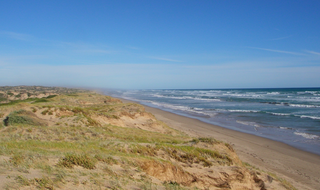
Coorong National Park is a protected area located in South Australia about 156 kilometres (97 mi) south-east of Adelaide, that predominantly covers a coastal lagoon ecosystem officially known as The Coorong and the Younghusband Peninsula on the Coorong's southern side. The western end of the Coorong lagoon is at the Murray Mouth near Hindmarsh Island and the Sir Richard Peninsula, and it extends about 130 kilometres (81 mi) south-eastwards. Road access is from Meningie. The beach on the coastal side of the peninsula, the longest in Australia, is also commonly called The Coorong.

Lake Alexandrina is a coastal freshwater lake located between the Fleurieu and Kangaroo Island and Murray and Mallee regions of South Australia, about 100 kilometres (62 mi) south-east of Adelaide. The lake adjoins the smaller Lake Albert and a coastal lagoon called The Coorong to its southeast, before draining into the Great Australian Bight via a short, narrow opening known as Murray Mouth.
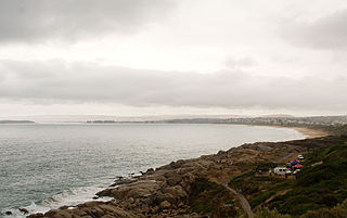
Encounter Bay is a bay in the Australian state of South Australia located on the state's south central coast about 100 kilometres (62 mi) south of the state capital of Adelaide. It was named by Matthew Flinders after his encounter on 8 April 1802 with Nicolas Baudin, the commander of the Baudin expedition of 1800–03. It is the site of both the mouth of the River Murray and the regional city of Victor Harbor. It is one of four "historic bays" located on the South Australian coast.
Hindmarsh Island is an inland river island located in the lower Murray River near the town of Goolwa, South Australia.
Goolwa, known as The Elbow to early settlers, is an historic river port on the Murray River near the Murray Mouth in South Australia. Goolwa is approximately 85 km (53 mi) south of Adelaide, and is joined by a bridge to Hindmarsh Island.

Murray Mouth is the point at which the River Murray meets the Southern Ocean. The Murray Mouth's location is changeable. Historical records show that the channel out to sea moves along the sand dunes over time. At times of greater river flow and rough seas, the two bodies of water would erode the sand dunes to create a new channel leaving the old one to silt and disappear.

Coorong is a locality in the Australian state of South Australia which is associated with the lagoon known as the Coorong in the south-east of the state and which overlooks the continental coastline from the mouth of the Murray River about 80 kilometres south-east of the state capital of Adelaide to the immediate north of the town of Kingston SE extending for a distance of at least 140 kilometres (87 mi).
Younghusband Peninsula is a long narrow peninsula in South Australia. It separates the Coorong Channel, the Tauwitchere Channel and the Coorong which are part of the estuary of the River Murray from the Southern Ocean which including water bodies such as Encounter and Lacepede Bays. It lies entirely within the Coorong National Park. The peninsula is over 110 kilometres (68 mi) long, but less than 3 kilometres (1.9 mi) wide at its widest point. Its narrowest point is less than 350 metres (1,150 ft) wide. The Younghusband Peninsula, together with the Sir Richard Peninsula on the western side of the Murray Mouth, are the coastal dune system that forms the continental coastline from near Goolwa in the north west to about 35 kilometres north of Kingston SE in the south east. Younghusband Peninsula was named after William Younghusband, M.P.

Wellington Weir was a weir proposed for the River Murray several kilometres south of the town of Wellington, South Australia, immediately upstream from where the river enters Lake Alexandrina.
The Murray–Darling Basin Authority (MDBA) is the principal government agency in charge of managing the Murray–Darling Basin in an integrated and sustainable manner. The MDBA is an independent statutory agency that manages, in conjunction with the Basin states, the Murray–Darling basin's water resources in the national interest. The MDBA reports to the Australian Government Minister for the Environment and Water, held since June 2022 by the Hon Tanya Plibersek.

Clayton Bay is a town in South Australia located on Lake Alexandrina and Lower Murray River, part of the lower lakes and Coorong region at the end of the Murray River System. The town is located north of the north-east tip of Hindmarsh Island about 87 kilometres (54 mi) from Adelaide and 30.7 kilometres (19 mi) by road from Goolwa.
Water security in Australia became a major concern in Australia in the late 20th and early 21st century as a result of population growth, recurring severe droughts, effects of climate change on Australia, environmental degradation from reduced environmental flows, competition between competing interests such as grazing, irrigation and urban water supplies, and competition between upstream and downstream users. For example, there is competition for the resources of the Darling River system between Queensland, New South Wales and South Australia. Water reform was first placed on the national agenda at the 1994 Council of Australian Governments (COAG) meeting when a strategic framework was devised. As the knowledge of surface and groundwater systems grew and the awareness of the significance of sustainable water markets increased, further water reform was agreed to at the 2004 COAG meeting, under a national blueprint known as the National Water Initiative (NWI).

The Goolwa Barrages comprise five barrage structures in the channels separating Lake Alexandrina from the sea at the mouth of the River Murray and the Coorong in South Australia. They were constructed principally to reduce salinity levels in the lower reaches of the River Murray, Lake Alexandrina and Lake Albert, but also to stabilise the river level, for both upstream irrigation and pumping.
Sabine Dittmann is an Australian-based marine biologist and expert on the ecology of tidal flats. She is Associate Professor of Marine Biology at Flinders University in Adelaide, and is President of the Australian Marine Sciences Association.
Centre Alliance, formerly known as the Nick Xenophon Team (NXT), is a centrist political party in Australia based in the state of South Australia. It currently has one representative in the Parliament, Rebekha Sharkie in the House of Representatives.
Coorong may refer to:
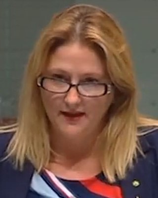
Rebekha Carina Sharkie is an Australian politician and member of the Centre Alliance party. She is a member of the Australian House of Representatives, representing the Division of Mayo in South Australia.
Goolwa North is a locality in the Australian state of South Australia located about 66 kilometres south of the state capital of Adelaide and 2.5 kilometres northeast of the centre of the municipal seat of Goolwa overlooking the following water bodies in the Murray River system - Currency Creek to the north and the channel known as Goolwa or the Lower Murray to the south-east.
References
- 1 2 "Water – Goyder". CSIRO. 21 October 2021. Retrieved 11 March 2024.
- 1 2 Goyder Institute Annual Report 2014/2015 (PDF) (Report). 2015.
- 1 2 3 4 5 Horn, Caroline (4 February 2024). "Goolwa research centre to focus on climate change solutions for Coorong, Lower Lakes and Murray Mouth". ABC News (Australia) . Retrieved 10 March 2024.
- ↑ "Who We Are – Goyder Institute". Goyder Institute. 15 March 2023. Retrieved 10 March 2024.
- ↑ "Management Board". Goyder Institute. Retrieved 10 March 2024.
- 1 2 "Goyder Institute for Water Research announces new Chair – Goyder Institute". Goyder Institute. 30 November 2023. Retrieved 10 March 2024.
- ↑ "Goyder Institute for Water Research Coorong, Lower Lakes and Murray Mouth Research Centre". DCCEEW . 20 October 2023. Retrieved 10 March 2024.
- 1 2 "New research hub to help future-proof water resources in Goolwa region". The Hon Tanya Plibersek MP. 6 October 2022. Retrieved 11 March 2024.
- ↑ Goyder Institute for Water Research (2011), Goyder Institute for Water Research technical report series, Goyder Institute for Water Research, ISSN 1839-2725