Andfiskvatnet is a lake in the municipality of Rana in Nordland county, Norway. The 2.7-square-kilometre (1.0 sq mi) lake lies about 3 kilometres (1.9 mi) southeast of the village of Hauknes and about 6 kilometres (3.7 mi) south of the town of Mo i Rana. The lake flows out into the river Andfiskåga which flows into the Ranfjorden.

Faulvatnet (Norwegian) or Låddejávrre (Lule Sami) is a lake that lies in the municipality of Sørfold in Nordland county, Norway. The 7.24-square-kilometre (2.80 sq mi) lake is located about 15 kilometres (9.3 mi) north of the village of Straumen, just west of Rago National Park. The water flows out into the Sleipdalselva river and the water is used for power generation at the Lakshola hydroelectric power station.
Heggmovatnet is a lake that lies in the municipality of Bodø in Nordland county, Norway. The 9.38-square-kilometre (3.62 sq mi) lake is located about 10 kilometres (6.2 mi) northeast of the village of Løding. The lake is regulated and it is the main water source for the town of Bodø. The water flows out of the lake into the river Heggmoelva, which then flows into the lake Vatnvatnet. Sjunkhatten National Park surrounds the lake.

Rien is a lake in the municipality of Røros in Trøndelag county, Norway. The 14.87-square-kilometre (5.74 sq mi) lake is located near the headwaters of the river Glomma, only about 10 kilometres (6.2 mi) east of the border with Sweden. The water flows out through the river Glomma and heads a short distance south, into the large lake Aursunden. The village of Brekken lies about 6 kilometres (3.7 mi) south of the lake and the town of Røros lies about 40 kilometres (25 mi) to the southwest.
Gagnåsvatnet or Gangåsvatnet is a lake in the municipality of Orkdal in Trøndelag county, Norway. The 5.49-square-kilometre (1,360-acre) lake is located about 9 kilometres (5.6 mi) southwest of the town of Orkanger and about 6 kilometres (3.7 mi) west of the village of Fannrem in the Orkdalen valley.

Svorksjøen is a lake in Trøndelag county, Norway. The 3.55-square-kilometre (1.37 sq mi) lake lies on the border of the municipalities of Melhus, Meldal, and Orkdal. The lake lies about 6 kilometres (3.7 mi) east of the village of Svorkmo in Orkdal and about 10 kilometres (6.2 mi) southwest of the village of Korsvegen in Melhus.
Nilsebuvatnet is a lake in the municipalities of Forsand and Hjelmeland in Rogaland county, Norway. The 2.47-square-kilometre (0.95 sq mi) lake lies in the Lyseheiane mountains about 13 kilometres (8.1 mi) north of the village of Lysebotn and about 25 kilometres (16 mi) east of the village of Årdal. The lake is regulated by a small dam on the southwest corner of the lake. The dam provides water for the Lysebotn power station. The lake drains out into the river Storåna which flows westward towards Årdal. The lake is accessible by a small service road from Lysebotn which leads up to the dam.
Byrkjelandsvatnet or Storavatnet is a lake in the municipality of Bjerkreim in Rogaland county, Norway. The 5.17-square-kilometre (2.00 sq mi) lake lies about 2 kilometres (1.2 mi) north of the village of Øvrebygd. The lake flows out through the short river Malmeisåna which flows into the lake Hofreistæ.

Øyarvatnet or Øyarvatn is a lake in Norway. It sits on the border between the municipalities of Valle in Aust-Agder county and Sirdal in Vest-Agder county, about 30 kilometres (19 mi) northeast of the village of Lunde, Sirdal and about 32 kilometres (20 mi) west of Austad in Bygland. The lake is part of the Kvina river system. It is located just to the south of the lake Rosskreppfjorden, which flows into it. The dam at the south end of the 8.05-square-kilometre (3.11 sq mi) lake keeps it at an elevation of 837 metres (2,746 ft).
Longerakvatnet or Longeraksvatnet is a lake in the municipality of Bygland in Aust-Agder county, Norway. It has a small dam on the southwest side to regulate the water level for hydro-electric power generation at a plant located down the hill. The lake discharges into the Longeraksåni river which flows into the Byglandsfjorden near the village of Longerak. The 3.4-square-kilometre (1.3 sq mi) lake is located about 6 kilometres (3.7 mi) southeast of the village of Lauvdal and about 10 kilometres (6.2 mi) northeast of the village of Byglandsfjord.

Syndle is a lake in the municipality of Grimstad in Aust-Agder county, Norway. It is located in the Landvik area, about 5 kilometres (3.1 mi) northwest of the center of the town of Grimstad. The 6-square-kilometre (2.3 sq mi) lake Syndle flows into a small river on the northeast part of the lake which connects it to the neighboring lake Rore which eventually flows into the river Nidelva.
Holden is a lake in the municipality of Verran in Trøndelag county, Norway. It is located about 8 kilometres (5.0 mi) west of the village of Malm and about 10 kilometres (6.2 mi) north of the village of Follafoss. The 13.31-square-kilometre (5.14 sq mi) lake has a dam on the southern end to control the water for hydroelectric power. The lake flows out into the Follaelva river which flows into the Trondheimsfjord at the village of Follafoss.
Skogseidvatnet is a lake in the municipality of Fusa in Hordaland county, Norway. The 5.3-square-kilometre (2.0 sq mi) lake lies in the Hålandsdal valley, about 7 kilometres (4.3 mi) east of the municipal centre of Eikelandsosen. Water from the river Orraelva and the lake Gjønavatnet flow into the lake, and then it flows out into the lake Henangervatnet before flowing out into the fjord.

Gravatnet is a lake in the municipality of Sirdal in Vest-Agder county, Norway. The 5.33-square-kilometre (2.06 sq mi) lake is located about 9 kilometres (5.6 mi) north of the small village of Lunde. The lake lies immediately south of the lake Valevatn, which flows out into Gravatnet. The water in Gravatnet is stopped by a dam on the south side. The water is regulated at an elevation of 660 metres (2,170 ft) and it flows out through the small river Gravassåni which is a tributary of the big river Sira.
Hoklingen is a lake in the municipality of Levanger in Trøndelag county, Norway. The 6.1-square-kilometre (2.4 sq mi) lake lies just to the east of the village of Åsen and about 6 kilometres (3.7 mi) south of the village of Skogn.
Ormsetvatnet is a lake in the municipality of Verran in Trøndelag county, Norway. It is located about 10 kilometres (6.2 mi) northeast of the village of Verrabotn. The 4.27-square-kilometre (1.65 sq mi) lake has a dam at the southern end, the water flows out into the short river Moldelva which flows out into an arm of the Trondheimsfjord.

Stuorajávri is a lake in Alta Municipality in Finnmark county, Norway. The 3.58-square-kilometre (1.38 sq mi) lake lies about 3.5 kilometres (2.2 mi) northeast of the Sautso canyon, along the Altaelva river, into which this lake eventually flows.

Lovatnet is a lake in the municipality of Stryn in Sogn og Fjordane county, Norway. It is located about 2 kilometres (1.2 mi) southeast of the village of Loen and about 6 kilometres (3.7 mi) east of the village of Olden. The lake lies just 2 kilometres (1.2 mi) southwest of the mountain Skåla. The water from the lake flows down from the mountains; especially from the Jostedalsbreen and Tindefjellbreen glaciers. It then flows out through the Loelva river into the Nordfjorden.

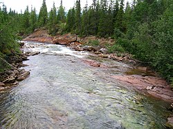
Ranelva is a 130-kilometre (81 mi) long river in the municipality of Rana in Nordland county, Norway. It is one of the longest rivers in Nordland county. The catchment area of the river is 3,790 square kilometres (1,460 sq mi). Before the power stations of Reinforsen (1925) and Langvatnet (1964) were built, the catchment area was 3,843 square kilometres (1,484 sq mi).
Langavatnet is a lake in the municipality of Odda in Hordaland county, Norway. The 6.19-square-kilometre (2.39 sq mi) lake lies about 10 kilometres (6.2 mi) straight east of the town of Odda. The lake has a dam at the north end to regulate the water level for the purposes of hydroelectric power generation. The water of the lake previously flowed north to create the large Ringedalsfossen waterfall which now only flows when the lake gets too full. The water flows over the falls into the lake Ringedalsvatnet before flowing through the short river Tysso which empties into the Sørfjorden.