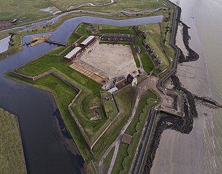
Tilbury Fort, also known historically as the Thermitage Bulwark and the West Tilbury Blockhouse, is an artillery fort on the north bank of the River Thames in England. The earliest version of the fort, comprising a small blockhouse with artillery covering the river, was constructed by King Henry VIII to protect London against attack from France as part of his Device programme. It was reinforced during the 1588 Spanish Armada invasion scare, after which it was reinforced with earthwork bastion, and Parliamentary forces used it to help secure the capital during the English Civil War of the 1640s. Following naval raids during the Anglo-Dutch Wars, the fort was enlarged by Sir Bernard de Gomme from 1670 onwards to form a star-shaped defensive work, with angular bastions, water-filled moats and two lines of guns facing onto the river.
Isle of Grain is a village and the easternmost point of the Hoo Peninsula within the district of Medway in Kent, south-east England. No longer an island and now forming part of the peninsula, the area is almost all marshland and is a major habitat for diverse wetland birds. The village constitutes a civil parish, which at the 2011 census had a population of 1,648, a net decrease of 83 people in 10 years.

The Western Heights of Dover is a series of forts and ditches in Dover, England. They were created in the 18th and 19th centuries to augment the existing defences and protect the key port of Dover from both seaward and landward attack; by the start of the 20th century Dover Western Heights was collectively reputed to be the 'strongest and most elaborate' fortification in the country. The Army finally withdrew from the Heights in 1956–61; they are now a local nature reserve.
Grain Fort is a former artillery fort located just east of the village of Grain, Kent. It was constructed in the 1860s to defend the confluence of the Rivers Medway and Thames during a period of tension with France. The fort's location enabled its guns to support the nearby Grain Tower and Garrison Point Fort at Sheerness on the other side of the Medway. It was repeatedly altered and its guns upgraded at various points in its history, before being decommissioned in 1956 when the UK abolished its coastal defence programme. It was subsequently demolished. The remnants of the fort are still visible and have been incorporated into a coastal park.

Garrison Point Fort is a former artillery fort situated at the end of the Garrison Point peninsula at Sheerness on the Isle of Sheppey in Kent. Built in the 1860s in response to concerns about a possible French invasion, it was the last in a series of artillery batteries that had existed on the site since the mid-16th century. The fort's position enabled it to guard the strategic point where the River Medway meets the Thames. It is a rare example of a two-tiered casemated fort – one of only two of that era in the country – with a design that is otherwise similar to that of several of the other forts along the lower Thames. It remained operational until 1956 and is now used by the Sheerness Docks as a port installation.

Slough Fort is a small artillery fort that was built at Allhallows-on-Sea in the north of the Hoo Peninsula in Kent. Constructed in 1867, the D-shaped fort was intended to guard a vulnerable stretch of the River Thames against possible enemy landings during a period of tension with France. Its seven casemates initially accommodated rifled breech loading guns, which were replaced by the turn of the century by more powerful breech-loaders on disappearing carriages, mounted in concrete wing batteries on either side of the fort. It was likely one of the smallest of the forts constructed as a result of the 1860s invasion scare.

New Tavern Fort is an historic artillery fort in Gravesend, Kent. Dating mostly from the 18th and 19th centuries, it is an unusually well-preserved example of an 18th-century fortification and remained in use for defensive purposes until the Second World War. It was built during the American War of Independence to guard the Thames against French and Spanish raiders operating in support of the newly formed United States of America. It was redesigned and rebuilt in the mid-19th century to defend against a new generation of iron-clad French warships.

Shornemead Fort is a now-disused artillery fort that was built in the 1860s to guard the entrance to the Thames from seaborne attack. Constructed during a period of tension with France, it stands on the south bank of the river at a point where the Thames curves sharply north and west, giving the fort long views up and downriver in both directions. It was the third fort constructed on the site since the 18th century, but its location on marshy ground led to major problems with subsidence. The fort was equipped for a time with a variety of large-calibre artillery guns which were intended to support two other nearby Thamesside forts. However, the extent of the subsidence meant that it became unsafe for the guns to be fired and the fort was disarmed by the early 20th century.
Coalhouse Fort is an artillery fort in the eastern English county of Essex. It was built in the 1860s to guard the lower Thames from seaborne attack. It stands at Coalhouse Point on the north bank of the river, at a location near East Tilbury which was vulnerable to raiders and invaders. It was the last in a series of fortifications dating back to the 15th century and was the direct successor to a smaller mid-19th century fort built on the same site. Constructed during a period of tension with France, its location on marshy ground caused problems from the start and led to a lengthy construction process. The fort was equipped with a variety of large-calibre artillery guns and the most modern defensive facilities of the time, including shell-proof casemates protected by granite facing and cast-iron shields. Its lengthy construction and the rapid pace of artillery development at the time meant that it was practically obsolete for its original purpose within a few years of its completion.

Fort Luton was built between 1876 and 1892 south of Chatham, Medway, South East England. It is one of the five late Victorian land front forts built to defend the overland approaches to Chatham. It is the smallest of the Chatham forts and was built near to the village of Luton.

Beacon Hill Battery is a late-19th and 20th century coastal fortification that was built to defend the port of Harwich, Essex. It is a scheduled ancient monument.

Fort Rodd Hill National Historic Site is a 19th-century coastal artillery fort on the Colwood side of Esquimalt Harbour,. The site is adjacent to Fisgard Lighthouse National Historic Site, the first lighthouse on the west coast of Canada. Both the fort and lighthouse are managed and presented to the public by Parks Canada.

Cliffe Fort is a disused artillery fort built in the 1860s to guard the entrance to the River Thames from seaborne attack. Constructed during a period of tension with France, it stands on the south bank of the river at the entrance to Cliffe Creek in the Cliffe marshes on the Hoo Peninsula in North Kent, England. Its location on marshy ground caused problems from the start and necessitated changes to its design after the structure begin to crack and subside during construction. The fort was equipped with a variety of large-calibre artillery guns which were intended to support two other nearby Thamesside forts. A launcher for the Brennan torpedo—which has been described as the world's first practical guided missile—was installed there at the end of the 19th century but was only in active use for a few years.

Culver Battery is a former coastal artillery battery on Culver Down, on the eastern side of the Isle of Wight, England. The fortification is one of several Palmerston Forts built on the island following concerns about the size and strength of the French Navy in the late 19th century. It was operational during the First and Second World Wars. The battery was closed in 1956.

Grain Tower is a mid-19th-century gun tower situated offshore just east of Grain, Kent, standing in the mouth of the River Medway. It was built along the same lines as the Martello towers that were constructed along the British and Irish coastlines in the early 19th century and is the last-built example of a gun tower of this type. It owed its existence to the need to protect the important dockyards at Sheerness and Chatham from a perceived French naval threat during a period of tension in the 1850s.

The Stokes Bay Lines were part of the great Victorian fortification of Portsmouth Harbour under Lord Palmerston. In 1857 Major Jervois had proposed a complex system of moats (ditches), ramparts and batteries to close off the gap between the new fort at Fort Gomer, and the earlier fort at Fort Gilkicker, and Fort Monckton. This defensive moat was to become the ‘Stokes Bay Lines’.
Fort Horsted is a scheduled monument that lies in the Horsted Valley to the South of Chatham, Kent, England. It is a late 19th-century Land Fort, and one of six constructed around Chatham and Gillingham, Kent to protect HM Dockyard Chatham from attack. Originally proposed in the Royal Commission on the Defence of the United Kingdom Report, published in 1860, it and the other land defences were omitted as part of general cost cutting with only the coastal defences on the River Medway being retained and completed under the original 1860 proposals. It was not until the mid-1870s that a revised programme was accepted, which included the construction of a convict prison at Borstal, Rochester, to provide low cost labour for the construction of a line of four forts, Fort Borstal, Fort Bridgewood, Fort Horsted and Fort Luton. Its construction started in 1879 and was complete by 1889 after much delay.

The Twydall Profile was a style of fortification used in British and Imperial polygonal forts at the end of the 19th century. The sloping earthworks employed in the Twydall Profile were intended to be quick and inexpensive to construct and to be effective in the face of the more powerful artillery and high explosive ammunition being introduced at that time. The name comes from the village of Twydall in Kent, where the first forts of this type were built.

Dummy Battery, originally known as Grain Battery, is a disused fortified gun battery located about 1 kilometre (0.62 mi) south of the village of Grain, Kent at the confluence of the Rivers Thames and Medway. Completed in 1865, it supported two nearby coast artillery batteries at Grain Fort and Grain Wing Battery, a short distance to the north. The battery's arc of fire overlapped with Grain Tower just offshore and with Garrison Point Fort on the Isle of Sheppey across the other side of the Medway. It consisted of an earthwork with a concrete core supporting several gun emplacements with magazines below. It appears to have gone out of service as a battery by the time of the First World War, though it briefly took on a role in anti-aircraft defence. It was subsequently abandoned and was severely damaged by demolitions and the removal of its earthworks, leaving only the substantial remains of its concrete core standing today.

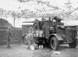
The Thames and Medway Coast Artillery, which at its peak comprised three full regiments, was formed in Britain's Territorial Army in 1932 to man coastal defence guns on both banks of the Thames Estuary. It served in this role during World War II, at the end of which it sent troops to work in the rear areas in Europe. It was reformed postwar but was broken up when the coast artillery branch was abolished in 1956.

