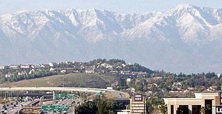
Corona is a city in northwestern Riverside County, California, United States. At the 2020 census, the city had a population of 157,136, up from 152,374 at the 2010 census. Corona is surrounded by Norco to the north and northeast, Yorba Linda to the northwest, Cleveland National Forest and the Santa Ana Mountains to the west, southwest, and south. Several unincorporated communities are along the rest of the city's borders. Downtown Corona is approximately 48 miles southeast of Downtown Los Angeles and 95 miles (153 km) north-northwest of San Diego.

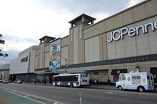
Corona is a neighborhood in the borough of Queens in New York City. It borders Flushing and Flushing Meadows–Corona Park to the east, Jackson Heights to the west, Forest Hills and Rego Park to the south, Elmhurst to the southwest, and East Elmhurst to the north. Corona's main thoroughfares include Corona Avenue, Roosevelt Avenue, Northern Boulevard, Junction Boulevard, and 108th Street.

Elmhurst is a neighborhood in the borough of Queens in New York City. It is bounded by Roosevelt Avenue on the north; the Long Island Expressway on the south; Junction Boulevard on the east; and the New York Connecting Railroad on the west.

State Route 91 (SR 91) is a major east–west state highway in the U.S. state of California that serves several regions of the Greater Los Angeles urban area. A freeway throughout its entire length, it officially runs from Vermont Avenue in Gardena, just west of the junction with the Harbor Freeway, east to Riverside at the junction with the Pomona and Moreno Valley freeways.

North University Park is a neighborhood in Los Angeles, California. Located just north of the University of Southern California, North University Park contains two historic districts that are both on the National Register of Historic Places: The North University Park Historic District and the Menlo Avenue–West Twenty-ninth Street Historic District.

State Route 71 (SR 71) is a 15-mile (24 km) state highway in the U.S. state of California. Serving Riverside, San Bernardino, and Los Angeles counties, it runs from SR 91 in Corona to the Kellogg Interchange with I-10 and SR 57 on the border of Pomona and San Dimas. The segment from SR 91 to SR 83 in Chino Hills is called the Corona Freeway, formerly the Corona Expressway and before then the Temescal Freeway. SR 71 is designated as the Chino Valley Freeway between SR 83 and the Kellogg Interchange.

Wilshire Boulevard (['wɪɫ.ʃɚ]) is a prominent 15.83 mi (25.48 km) boulevard in the Los Angeles area of Southern California, extending from Ocean Avenue in the city of Santa Monica east to Grand Avenue in the Financial District of downtown Los Angeles. One of the principal east–west arterial roads of Los Angeles, it is also one of the major city streets through the city of Beverly Hills. Wilshire Boulevard runs roughly parallel to Santa Monica Boulevard from Santa Monica to the west boundary of Beverly Hills. From the east boundary, it runs a block south of Sixth Street to its terminus.

Woodbridge is a historic neighborhood of primarily Victorian homes located in Detroit, Michigan. The district was listed on the National Register of Historic Places in 1980, with later boundary increases in 1997 and 2008. In addition to its historic value, Woodbridge is also notable for being an intact neighborhood of turn-of-the-century homes within walking or biking distance of Detroit's Downtown, Midtown, New Center, and Corktown neighborhoods.

The Grand Concourse is a 5.2-mile-long (8.4 km) thoroughfare in the borough of the Bronx in New York City. Grand Concourse runs through several neighborhoods, including Bedford Park, Concourse, Highbridge, Fordham, Mott Haven, Norwood and Tremont. For most of its length, the Concourse is 180 feet (55 m) wide, though portions of the Concourse are narrower.

Myron Hubbard Hunt was an American architect whose numerous projects include many noted landmarks in Southern California and Evanston, Illinois. Hunt was elected a Fellow in the American Institute of Architects in 1908.

Washington Boulevard Historic District is a multi-block area of downtown Detroit, Michigan. It consists of structures facing Washington Boulevard between State and Clifford Streets. In 1982, it was added to the National Register of Historic Places. It includes the Book-Cadillac Hotel, the Book Tower, the Industrial Building, and Detroit City Apartments among other architecturally significant buildings. Washington Boulevard is one of the city's main boulevards and part of Augustus Woodward's 1807-design for the city. Because Woodward's plan was never completed, the boulevard contains a sharp curve south of Michigan Avenue where it was connected to an existing street.

The Frank B. Kellogg House is a historic house at 633 Fairmount Avenue in Saint Paul, Minnesota, United States. It is listed as a National Historic Landmark for its association with Nobel Peace Prize-winner Frank B. Kellogg, co-author of the Kellogg–Briand Pact. Kellogg Boulevard in downtown Saint Paul is also named for him. The house was designated a National Historic Landmark in 1976. It is also a contributing property to the Historic Hill District.

The Saint Paul City Hall and Ramsey County Courthouse, located at 15 Kellogg Boulevard West in Saint Paul, Ramsey County, in the U.S state of Minnesota is a twenty-story Art Deco skyscraper completed in 1932. This was built during the Great Depression, the era of high unemployment and falling prices, the four million dollar budget for the building was underspent, and the quality of materials and craftsmanship exceeded initial expectations. The exterior consists of smooth Indiana limestone in the Art Deco style known as "American Perpendicular", which was designed by Thomas Ellerbe & Company of Saint Paul and Holabird & Root of Chicago and inspired by Finnish architect, Eliel Saarinen. The vertical rows of windows are linked by plain, flat, black spandrels. Above the Fourth Street entrance, and flanking the Kellogg Boulevard entrance, are relief sculptures carved by Lee Lawrie.
Boulevard Park is a historic residential neighborhood in Sacramento, California. It is also the Boulevard Park Historic District, listed on the National Register of Historic Places.

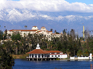
The Lake Norconian Club is a historic former hotel/resort in Norco, California, opened in 1929, sited in a rural community, whose main businesses were poultry, rabbits, and agriculture. It was later known as The Norconian and Clark's Hot Springs. The resort complex is still largely intact, after over 70 years as a naval base and prison. It was listed on the National Register of Historic Places in 2000. The listing included seven contributing buildings, five contributing structures, and a contributing site.

Morton Street is a street in southern Boston, Massachusetts, United States. It extends from the southeastern end of the Arborway in Jamaica Plain to Washington Street in the Lower Mills Village of Dorchester. Most of the road is a connecting parkway, signed as part of Massachusetts Route 203, that provides access to Boston's Emerald Necklace of parks. That portion of the road was listed on the National Register of Historic Places in 2005.

The East Grand Boulevard Historic District is a historic district located along East Grand Boulevard between East Jefferson Avenue and Mack Avenue in Detroit, Michigan. The district was listed on the National Register of Historic Places in 1999.

La Habra–Fullerton–Yorba Linda Line was a Pacific Electric interurban line which traveled between Los Angeles and Yorba Linda. Passenger services ran between 1911 and 1938. Initial plans were for the route to continue further east to form a second main line between Los Angeles and San Bernardino, though these would go unfulfilled. After passenger service ended, much of the route was retained for freight service, eventually becoming the Union Pacific La Habra Subdivision.

The Corona Founders Monument is a monument built in 1936 to the founding fathers of the City of Corona in the Riverside County, California. The monument was designated a California Historic Landmark (No.738) on June 6, 1960. The monument is in the Corona City Park in the 100 block of 6th Street of Corona, California. The founding fathers at first called the city South Riverside after the company they started the South Riverside Land and Water Company.


