
ThePacific Coast Ranges, are the series of mountain ranges that stretch along the West Coast of North America from Alaska south to Northern and Central Mexico.

The Saint Elias Mountains are a subgroup of the Pacific Coast Ranges, located in southeastern Alaska in the United States, Southwestern Yukon and the very far northwestern part of British Columbia in Canada. The range spans Wrangell-St. Elias National Park and Preserve in the United States and Kluane National Park and Reserve in Canada and includes all of Glacier Bay National Park in Alaska. In Alaska, the range includes parts of the city/borough of Yakutat and the Hoonah-Angoon and Valdez-Cordova census areas.
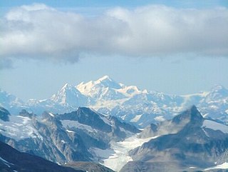
Mount Fairweather, is the highest mountain in the Canadian province of British Columbia, with an elevation of 4,671 metres. It is located 20 km (12 mi) east of the Pacific Ocean on the border of Alaska, United States and western British Columbia, Canada. Most of the mountain lies within Glacier Bay National Park and Preserve in the City and Borough of Yakutat, Alaska (USA), though the summit borders Tatshenshini-Alsek Provincial Park, British Columbia (Canada). It is also designated as Boundary Peak 164 or as US/Canada Boundary Point #164.

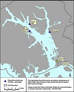
Glacier Bay National Park and Preserve is an American national park located in Southeast Alaska west of Juneau. President Calvin Coolidge proclaimed the area around Glacier Bay a national monument under the Antiquities Act on February 25, 1925. Subsequent to an expansion of the monument by President Jimmy Carter in 1978, the Alaska National Interest Lands Conservation Act (ANILCA) enlarged the national monument by 523,000 acres on December 2, 1980, and created Glacier Bay National Park and Preserve. The national preserve encompasses 58,406 acres of public land to the immediate northwest of the park, protecting a portion of the Alsek River with its fish and wildlife habitats, while allowing sport hunting.
Glacier Bay Basin in southeastern Alaska, in the United States, encompasses the Glacier Bay and surrounding mountains and glaciers, which was first proclaimed a U.S. National Monument on February 25, 1925, and which was later, on December 2, 1980, enlarged and designated as the Glacier Bay National Park and Preserve under the Alaska National Interest Lands Conservation Act, covering an area of 3,283,000 acres. In 1986, UNESCO declared an area of 57,000 acres within a World Biosphere Reserve. This is the largest UNESCO protected biosphere in the world. In 1992, UNESCO included this area as a part of a World Heritage site, extending over an area of 24,300,000-acre (98,000 km2) which also included the Wrangell-St. Elias National Park, Kluane National Park (Canada) and Tatshenshini-Alsek Park (Canada). Part of the National Park is also designated a Wilderness area covering 2,658,000 acres.

Tatshenshini-Alsek Park or Tatshenshini-Alsek Provincial Wilderness Park is a provincial park in British Columbia, Canada 9,580 km2 (3,700 sq mi). It was established in 1993 after an intensive campaign by Canadian and American conservation organizations to halt mining exploration and development in the area, and protect the area for its strong natural heritage and biodiversity values.

Fairweather Glacier is a 19-mile-long (31 km) glacier in Glacier Bay National Park and Preserve in the U.S. state of Alaska. It begins on the west slope of Mount Salisbury and continues west to its 1961 terminus 0.2 miles east of Cape Fairweather, 100 miles (161 km) northwest of Hoonah.

Grand Pacific Glacier is a 25-mile (40 km) long glacier in British Columbia and Alaska. It begins in Glacier Bay National Park in the St. Elias Mountains, 7 miles (11.2 km) southwest of Mount Hay, trends east into the Grand Pacific Pass area of British Columbia, and then southeast to the head of Tarr Inlet at Alaska-Canada boundary, 68 miles (109 km) west of Skagway.

Mount Crillon is a high peak of the Fairweather Range, the southernmost part of the Saint Elias Mountains. It lies southeast of Mount Fairweather, in the promontory between the Gulf of Alaska and Glacier Bay. It is included in Glacier Bay National Park. The peak was named after Felix-Francois-Dorothee de Bretton, Comte de Crillon, by his friend, the French explorer Jean Francois de Galaup de la Perouse.
Mount Salisbury is a peak in the Fairweather Range of Alaska, 6 miles (10 km) southeast of Mount Fairweather. Its east slopes feed one of the northern branches of the Johns Hopkins Glacier, which flows into Glacier Bay. On its western side is a large cirque, shared with Mount Fairweather, Mount Quincy Adams, and Lituya Mountain, which heads the Fairweather Glacier; this flows almost to the Pacific coast at Cape Fairweather.
Lituya Mountain is a peak in the Fairweather Range of Alaska, United States, south of Mount Fairweather. Its eastern slopes feed a branch of the Johns Hopkins Glacier, which flows into Glacier Bay. On its western side is a large cirque, shared with Mount Fairweather, Mount Quincy Adams, and Mount Salisbury, which heads the Fairweather Glacier; this flows almost to the Pacific coast at Cape Fairweather. The Lituya Glacier flows from the south side of the mountain into Lituya Bay on the Pacific coast.
Mount Quincy Adams is a mountain located on the border between United States and Canada. It is named after John Quincy Adams (1767–1848), the sixth president of the United States.

Mount Ulysses, is the highest mountain in the Muskwa Ranges of the Northern Canadian Rockies in British Columbia. It and neighbouring peaks are part of a group of names drawing on the epic poem The Odyssey, in which here Ulysses wanders for 10 years before being able to return home to Ithaca.

Hudman Glacier is a glacier draining south of Mount Landolt between Marze Peak and Miller Peak in Petvar Heights at the south end of the Sentinel Range, in the Ellsworth Mountains of Antarctica, flowing south-southeast to Minnesota Glacier. It was mapped by the United States Geological Survey from surveys and U.S. Navy air photos, 1957–59, and was named by the Advisory Committee on Antarctic Names for Captain Rayburn A. Hudman, United States Marine Corps, who died in the crash of a Lockheed P2V-2n Neptune, modified for extreme range, flying in sub zero temperatures and Ski equipped for landing on the Ice runways at McMurdo Sound Antarctica on October 18, 1956.
Somero Glacier is a tributary glacier 7 nautical miles (13 km) long, flowing northwest from Mount Fairweather to enter Liv Glacier just south of the west end of the Duncan Mountains. Named by Advisory Committee on Antarctic Names (US-ACAN) for George N. Somero, United States Antarctic Research Program (USARP) biologist at McMurdo Station, 1963–64, and winter 1965.

Alsek Glacier is a 24-kilometer (15 mi) long glacier in Glacier Bay National Park in the Panhandle of Alaska (USA). The name Alsek is of Tlingit origin and may mean "place where people rest". Glacier was named in 1901 by U.S. Navy Lieutenant Commander Moser, commander of the U.S. Bureau of Fisheries steamer USS Albatross.


