
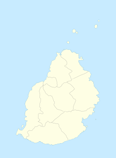
Grand Port is a district of Mauritius, situated in the east of the island. The name means "large port" in French. The district has an area of 260.3 km2 and the population estimate was at 112,997 as of 31 December 2015.

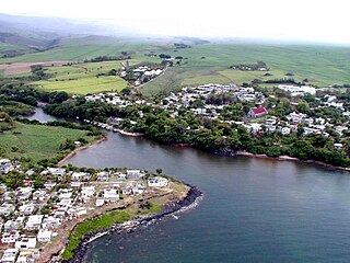
Mahébourg is a small town on the south-eastern coast of the island of Mauritius, having a population of 15,457 as of 2015. It is considered the main town of the Grand Port District.

The South Coast railway line is a commuter and goods railway line in New South Wales, Australia. Beginning at the Illawarra Junction, the line primarily services the Illawarra and South Coast regions of New South Wales, and connects Sydney and Bomaderry through Wollongong and Kiama.
Lincolnshire is a large county in England with a sparse population distribution, which leads to problems funding all sorts of transport. The transport history is long and varied, with much of the road network still based on the Roman model, and the once extensive rail network a shadow of its former self.
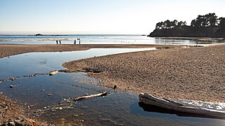
Van Damme State Park is a public beach consisting of about 1,831 acres (7.41 km2) of land in Mendocino County, California, near the town of Little River on State Route 1. It was named for Charles Van Damme (1881–1934), who was born in the area and purchased the land that is now the park with profits from a San Francisco ferry business. On his death, the property became part of the California state park system.
Souillac is a village close to the southernmost point of the main island of Mauritius. It is the seat of the district council of Savanne district. It was named after the Vicomte de Souillac, the island's governor from 1779-1787.

Garden Reach Shipbuilders & Engineers Ltd, abbreviated as GRSE, is one of India's leading shipyards, located in Kolkata, West Bengal. It builds and repairs commercial and naval vessels. Presently GRSE has also started building export ships in a mission to expand its business.
The Squamish Nation, Sḵwx̱wú7mesh Úxwumixw in Sḵwx̱wú7mesh Sníchim, is an Indian Act government originally imposed on the Squamish (Sḵwx̱wú7mesh) by the Federal Government of Canada in the late 19th century. The Squamish are Indigenous to British Columbia, Canada. Their band government comprises 16 elected councillors, serving four-year terms, with an elected band manager. Their main reserves are near the town of Squamish, British Columbia and around the mouths of the Capilano River, Mosquito Creek, and Seymour River on the north shore of Burrard Inlet in North Vancouver, British Columbia.

Highway 316 is a highway in the Canadian province of Saskatchewan. It runs from Highway 16 near Clavet to Highway 5. Highway 316 is about 17 km (11 mi.) long. This area is an industrial commercial area along Highway #316 which extends from Clavet north to the PCS Patience Lake Mine which is just 10 miles from the city of Saskatoon. Highway 316 is a primary weight highway, and also runs near the Canadian National Railway line which goes from Saskatoon through Clavet. In 1941, the Canadian Pacific Railway ran from Saskatoon through Cheviot and on south eastward.
The Whitefish River Valley is located in the unorganized area of Thunder Bay District, Ontario, and is named for the Whitefish River that flows through it. The valley is home to several small communities that developed when land was opened for homesteading along the Port Arthur, Duluth and Western Railway line at the turn of the 20th century and many people, particularly those from Finland, settled in the area. Today it has a population of approximately 1,362.

ALSIB was the Soviet Union portion of the Alaska-Siberian air road receiving Lend-Lease aircraft from the Northwest Staging Route. Aircraft manufactured in the United States were flown over this route for World War II combat service on the Eastern Front.
The Islets of Mauritius includes nearly a hundred tiny islets and rocks scattered around the coast of Mauritius as well as Rodrigues.

Bijapur District, formerly known as Birjapur, is one of the 27 districts of the state of Chhattisgarh in central India. It is one of the two new districts created on May 11, 2007. As of 2011 it is the second least populous district of Chhattisgarh, after Narayanpur. It is the second-least literate district in India, with a literacy rate of at 41.58%, according to the 2011 census.
Samburu is a village located in Kwale County, Kenya.

Mauritius was an official settlement of the Dutch East India Company on the island of Mauritius between 1638 and 1710, and used as a refreshing station for passing ships. It was already frequented by Dutch ships from 1598 onwards, but only settled in 1638, to prevent the French and the British from settling on the island.

Yukidori Valley lies in the middle of the Langhovde Hills, on the east coast of Lützow-Holm Bay, in Queen Maud Land of East Antarctica, about 20 km south of Japan's Showa Station. Yukidori is Japanese for “snow petrel”.
The Terekty River, also known under the Sinified spelling Tielieketi, is a small river that flows from China to Kazakhstan. In its lower course the river is also known as the Kusak. Along most of its course, the river flows through the very sparsely populated mountainous terrain of the southern part of Xinjiang's Yumin County; by the time it crosses the China–Kazakhstan border and enters a flat desert east of Lake Zhalanashkol, its bed is usually dry, with little water ever reaching Lake Zhalanashkol.
Rivière Du Poste is a village in the south part of Mauritius located in both Savanne and Grand Port district. The locality is about 19 miles south of Port Louis, the country's capital. The village is administered by the Rivière du Poste Village Council under the aegis of the Savanne District Council. According to the census made by Statistics Mauritius in 2011, the population was at 2,170. The neighboring villages are La Flora, Mare Tabac and Rose Belle and Camp Diable and Riviere Dragon in the south of the village.

Dikenafai is a town in Ideato South Local Government Area of Imo State, Nigeria, famous for its natural waterfall, Ezeama, which turns into the great Orashi River. Dikenafai currently serves as the headquarters of Ideato South.

Martinhoe is a small settlement and civil parish in North Devon district of Devon, England. Martinhoe is within the Exmoor National Park, the smallest National Park in England. In the 2011 census Martinhoe Parish was recorded as having a population of 159. Martinhoe is in the Combe Martin ward, for elections to the district council. Martinhoe's local government takes the form of a parish meeting and as such has no parish council nor elected parish councillors.
