Related Research Articles

Godfrey is a village in Madison County, Illinois, United States. The population was 17,982 at the 2010 census. Godfrey is located within the Greater St. Louis metropolitan area.

Neylandville is a town in Hunt County, Texas, United States. The population was 97 at the 2010 census, up from 56 at the 2000 census.

Mabscott is a town in Raleigh County, West Virginia, United States. The population was 1,408 at the 2010 census. The town's name is a contraction of the name Mabel Scott, wife of local coal operator Cyrus H. Scott.
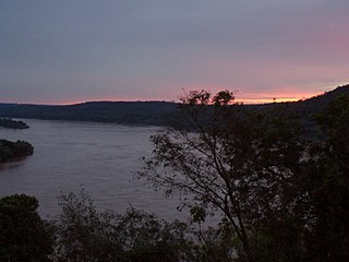
The Uruguay River is a major river in South America. It flows from north to south and forms parts of the boundaries of Brazil, Argentina, and Uruguay, separating some of the Argentine provinces of La Mesopotamia from the other two countries. It passes between the states of Santa Catarina and Rio Grande do Sul in Brazil; forms the eastern border of the provinces of Misiones, Corrientes, and Entre Ríos in Argentina; and makes up the western borders of the departments of Artigas, Salto, Paysandú, Río Negro, Soriano, and Colonia in Uruguay.

Barra do Quaraí is a Brazilian municipality located near the border with Uruguay and Argentina on the Uruguay River. The town became the westernmost city in the state of Rio Grande do Sul and in all Southern Brazil when it was separated from the municipality of Uruguaiana on December 28, 1995. The population is 4,227 in an area of 1056.14 km². Its elevation is 35 m. It is located 717 km west of the state capital of Porto Alegre, and roughly the same distance northwest of Montevideo, Uruguay. Under Brazilian law, the municipality includes an island named Ilha Brasileira, also claimed by Uruguay, where it is known as Isla Brasilera.

Estadio Defensores del Chaco is a multi-purpose stadium in Asunción, Paraguay. It is currently used mostly for football matches. The stadium once had a 50,000+ capacity, however over the years the stadium has undergone remodeling, dropping the capacity to 42,354. The stadium was again renovated in 2015.

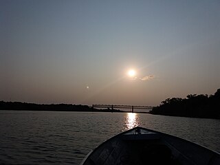
The Salto Grande Bridge is a road and railroad bridge that crosses the Uruguay River and joins Argentina and Uruguay. It is built on top of the Salto Grande Dam. The bridge runs between Concordia, Entre Ríos Province, Argentina, and Salto, Salto Department, Uruguay.

The Yí River is a river in Uruguay. The Yí and the Tacuarembó Rivers are the principal tributaries of the Río Negro.

Brazilian Island is a small uninhabited river island at the confluence of the Uruguay River and the Quaraí (Cuareim) River, between the borders of Argentina, Brazil and Uruguay, which is disputed by the two latter countries. The island is approximately 3.7 km (2.3 mi) long by 0.9 km (0.6 mi) wide, and it is located at 30°10′56″S57°37′43″W.

The Quaraí or Cuareim River is a tributary of the Uruguay River.
The Chamangá River is a river in Uruguay.
The Arapey Grande River is a river in the Salto Department of northwestern Uruguay. It flows from the northeast of department, with its headwaters near the border with Rivera Department, in a western direction and discharges in the Uruguay River. Its length is about 227 kilometres (141 mi). All of its tributaries are streams within Salto department, with its main tributaries streams being Arroyo Sarandí del Arapey, Arroyo Cambara, Arroyo Mataojo Chico, Arroyo Mataojo Grande, Arroyo del Sauce, Arroyo Valentín Grande and the Arapey Chico River, which forms part of the border with Artigas Department and has some tributaries from that department.
The Cebollatí River is a Uruguayan river that rises in Cuchilla Grande, flows southwest to northeast and forms a border between Treinta y Tres and Rocha.
The Santa Rosa River is a river of Rio Grande do Sul state in southern Brazil. It is a tributary of the Uruguay River.
Catanduvas, Paraná is a municipality in the state of Paraná in the Southern Region of Brazil.

This is a list of the extreme points of Uruguay, the points that are farther north, south, east or west than any other location, and the highest and lowest points. It is also notable that Uruguay's northernmost point is farther south than the northernmost point of any other nation.

The Brazil–Uruguay border is a strip of land located south of the southern Brazilian state of Rio Grande do Sul. It stretches for 985 km from the triple border Brazil-Argentina-Uruguay west to the mouth of Arroyo Chuí, the southernmost point in Brazil.

The border between the countries of France and the United Kingdom in Europe is a maritime border that stretches along the Channel, the North Sea and the Atlantic Ocean, the Channel Tunnel links the two countries underground and is defined as a 'Land Frontier', and not widely recognised as a Land Border.

The San Luis Hills are a group of small mountain ranges in Conejos and Costilla counties in the San Luis Valley in southern Colorado. The individual mountain ranges that make up the San Luis Hills include the Fairy Hills, the Brownie Hills, the Piñon Hills, and the South Piñon Hills. The San Luis Hills' highest point is Flat Top, elevation 9,206 feet
References
This article needs additional citations for verification .(November 2008) |
- ↑ "Archived copy". Archived from the original on 2008-09-16. Retrieved 2008-09-16.CS1 maint: archived copy as title (link)