
Coos County is one of the 36 counties in the U.S. state of Oregon. As of the 2020 census, the population was 64,929. The county seat is Coquille. The county was formed from the western parts of Umpqua and Jackson counties. It is named after a tribe of Native Americans who live in the region. Coos County comprises the Coos Bay, OR Micropolitan Statistical Area.

The Klamath Mountains are a rugged and lightly populated mountain range in northwestern California and southwestern Oregon in the western United States. As a mountain system within both the greater Pacific Coast Ranges and the California Coast Ranges, the Klamath Mountains have a varied geology, with substantial areas of serpentinite and marble, and a climate characterized by moderately cold winters with very heavy snowfall and warm, very dry summers with limited rainfall, especially in the south. As a consequence of the geology and soil types, the mountains harbor several endemic or near-endemic trees, forming one of the largest collections of conifers in the world. The mountains are also home to a diverse array of fish and animal species, including black bears, large cats, owls, eagles, and several species of Pacific salmon. Millions of acres in the mountains are managed by the United States Forest Service. The northernmost and largest sub-range of the Klamath Mountains are the Siskiyou Mountains.

The Coquille River is a stream, about 36 miles (58 km) long, in southwestern Oregon in the United States. It drains a mountainous area of 1,059 square miles (2,740 km2) of the Southern Oregon Coast Range into the Pacific Ocean. Its watershed is between that of the Coos River to the north and the Rogue River to the south.
The Big River is a tributary of the Coast Fork Willamette River, approximately 12 miles (19 km) long, in western Oregon in the United States. It drains an area of the Calapooya Mountains south of Eugene.

The Hells Canyon Wilderness is a wilderness area in the western United States, in Idaho and Oregon. Created 49 years ago in 1975, the Wilderness is managed by both the U.S. Bureau of Land Management and the U.S. Forest Service and contains some of the most spectacular sections of the Snake River as it winds its way through Hells Canyon, North America's deepest river gorge and one of the deepest gorges on Earth. The Oregon Wilderness Act of 1984 added additional acreage and currently the area protects a total area of 217,927 acres (88,192 ha). It lies entirely within the Hells Canyon National Recreation Area except for a small 946-acre (383 ha) plot in southeastern Wallowa County, Oregon which is administered by the Bureau of Land Management. The area that is administered by the Forest Service consists of portions of the Wallowa, Nez Perce, Payette, and Whitman National Forests.

The Oregon Coast Range, often called simply the Coast Range and sometimes the Pacific Coast Range, is a mountain range, in the Pacific Coast Ranges physiographic region, in the U.S. state of Oregon along the Pacific Ocean. This north-south running range extends over 200 miles (320 km) from the Columbia River in the north on the border of Oregon and Washington, south to the middle fork of the Coquille River. It is 30 to 60 miles wide and averages around 1,500 feet (460 m) in elevation above sea level. The coast range has three main sections, a Northern, Central, and Southern.

The Southern Oregon Coast Range is the southernmost section of the Oregon Coast Range, in the Pacific Coast Ranges, located in the southwest portion of the state of Oregon, United States, roughly between the Umpqua River and the middle fork of the Coquille River, beyond which are the Klamath Mountains. To the east is the Umpqua Valley and to the west the Pacific Ocean. This approximately 55-mile (89 km)-long mountain range contains mountains as high as 3,547 feet (1,081 m) for Bone Mountain. The mountains are known locally in the Roseburg area as the Callahan Mountains, or simply as The Callahans.

Cape Perpetua is a large forested headland projecting into the Pacific Ocean on the central Oregon Coast in Lincoln County, Oregon. The land is managed by the United States Forest Service as part of the Siuslaw National Forest.
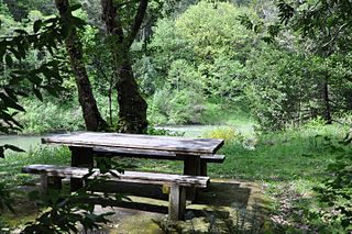
Coquille Myrtle Grove State Natural Site is a state park administered by the Oregon Parks and Recreation Department in the U.S. state of Oregon. The park, bordering the Powers Highway between Myrtle Point and Powers, in Coos County, features a swimming hole and sandy beach along the South Fork Coquille River. Other amenities include parking, picnic tables, restrooms, and access to fishing but no drinking water.

Camas Valley is an unincorporated community in Douglas County, Oregon, United States, in the valley of the same name. It is on Oregon Route 42, near the Middle Fork Coquille River.
Fairview is an unincorporated community in Coos County, Oregon, United States. Fairview is along the North Fork Coquille River about 6 miles (10 km) northeast of Coquille.

Little Butte Creek is a 17-mile-long (27 km) tributary of the Rogue River in the U.S. state of Oregon. Its drainage basin consists of approximately 354 square miles (917 km2) of Jackson County and another 19 square miles (49 km2) of Klamath County. Its two forks, the North Fork and the South Fork, both begin high in the Cascade Range near Mount McLoughlin and Brown Mountain. They both flow generally west until they meet near Lake Creek. The main stem continues west, flowing through the communities of Brownsboro, Eagle Point, and White City, before finally emptying into the Rogue River about 3 miles (5 km) southwest of Eagle Point.

The North Fork Coquille River is a 53-mile (85 km) tributary of the Coquille River in the southern Oregon Coast Range in the U.S. state of Oregon. It begins at an elevation of about 1,700 feet (520 m) above sea level and drops to 13 feet (4.0 m) near Myrtle Point, where it joins the South Fork Coquille River to form the main stem.
The South Fork Coquille River is the longest tributary of the Coquille River in coastal Oregon in the United States. From its headwaters in the Southern Oregon Coast Range, the river flows northwest to join the North Fork Coquille River at Myrtle Point, forming the main stem Coquille. The South Fork is about 63 miles (101 km) long, and its watershed drains roughly 288 square miles (750 km2) of rural Coos County.

Pseudotsuga menziesii var. menziesii, commonly known as Coast Douglas-fir, Pacific Douglas-fir, Oregon pine, or Douglas spruce, is an evergreen conifer native to western North America from west-central British Columbia, Canada southward to central California, United States. In Oregon and Washington its range is continuous from the Cascades crest west to the Pacific Coast Ranges and Pacific Ocean. In California, it is found in the Klamath and California Coast Ranges as far south as the Santa Lucia Mountains with a small stand as far south as the Purisima Hills, Santa Barbara County. In the Sierra Nevada it ranges as far south as the Yosemite region. It occurs from near sea level along the coast to 1,800 metres (5,900 ft) in the California Mountains. Further inland, coast Douglas-fir is replaced by Rocky Mountain or interior Douglas-fir. Interior Douglas-fir intergrades with coast Douglas-fir in the Cascades of northern Washington and southern British Columbia.
Whitehorse Falls is a 14-foot (4.3 m) waterfall on the Clearwater River, in Douglas County in the U.S. state of Oregon. It is located within the Whitehorse Falls Campground, about 4 miles east of Toketee Lake along Oregon Route 138.
Myrtle Creek is a short tributary of the South Umpqua River in Douglas County in the U.S. state of Oregon. Its main stem, formed by the confluence of two forks just south of the city of Myrtle Creek, is only about 1 mile (1.6 km) long. Its only named tributaries are the two forks, North Myrtle Creek and South Myrtle Creek, each of which is much longer than the main stem.
The Middle Fork Coquille River is a tributary, about 40 miles (64 km) long, of the South Fork Coquille River in the U.S. state of Oregon. It begins near Camas Mountain in Douglas County in the Southern Oregon Coast Range. It flows generally south, bypassing the community of Camas Valley while passing through the valley of the same name, then curves west and north to Remote in Coos County. The Middle Fork then flows generally west, passes by the small community of Bridge, and meets the South Fork near Myrtle Point. The confluence with the South Fork is 41 miles (66 km) by water to where the main stem of the Coquille River enters the Pacific Ocean at Bandon.
The East Fork Coquille River is a tributary, about 34 miles (55 km) long, of the North Fork Coquille River in the U.S. state of Oregon. It begins near Bennett Rock in Douglas County in the Southern Oregon Coast Range.

The Nooksack Giant was a superlative Coast Douglas-fir that grew at Loop's Ranch in Maple Falls in Washington State. It was felled in early 1896 on the Alfred Bruce Loop Homestead with a crosscut saw by a team of men at the North Fork of the Nooksack river. The tree was measured with a tape after felling at 465 feet (142 m) in length, 33 ft 11 in in circumference, or nearly 11 ft in diameter at the base, and measured 220 feet to the first limb. Ring count showed this tree to be 480 years old. A cross section of the tree was displayed on the corner of Railroad Avenue and Holly Street, New Whatcom, with a wooden placard nailed to the cross section noting the particulars of the tree.
