Gran Via de les Corts Catalanes, more simply known as Gran Via[ˈɡɾam ˈbi.ə], is one of Barcelona's major avenues. With a length of 13.1 km (8.1 mi), it is the longest street in Catalonia and the 2nd longest in Spain, after Gran Vía de la Manga, in La Manga del Mar Menor, but is the one with more street numbers in Spain.

Line 9 is a line of the Barcelona Metro network that is currently under construction, with 24 stations open in Barcelona and the El Prat de Llobregat, L'Hospitalet de Llobregat, Badalona and Santa Coloma de Gramenet suburbs, since December 2009. Currently, the line is divided in two branches, waiting for the connection between them to be built. The Aeroport T1 - Zona Universitària section is called L9 South, and the La Sagrera - Can Zam section L9 North. Upon completion, it will be the longest automatic train operation metro line in Europe.
— Line 8, coloured pink and operated by FGC, is part of the Barcelona Metro network, and therefore of the larger ATM fare-integrated transport system. It joins Plaça Espanya, in the Sants-Montjuïc district of Barcelona with metropolitan area municipalities of L'Hospitalet de Llobregat, Cornellà de Llobregat and Sant Boi de Llobregat.

Plaça d'Espanya or Plaza de España in Spanish, is one of Barcelona's most important squares, built on the occasion of the 1929 International Exhibition, held at the foot of Montjuïc, in the Sants-Montjuïc district.
El Gornal, or simply Gornal, is a neighbourhood in L'Hospitalet de Llobregat, belonging to the metropolitan area of Barcelona. It's part of District VI of L'Hospitalet, along with Bellvitge. Its creation started with the urban expansion of Bellvitge into empty terrains around Renfe railtracks. From the 1970s on it has been growing extensively, with the introduction of apartment blocks destined for low-income people.
Ildefons Cerdà is a railway station on the Llobregat–Anoia Line. It is not properly located in Plaça d'Ildefons Cerdà, but in the L'Hospitalet de Llobregat municipality, in Catalonia, Spain. The station is situated underneath Gran Via de les Corts Catalanes and was opened in 1987. It is served by Barcelona Metro line 8, Baix Llobregat Metro lines S33, S4 and S8, and commuter rail lines R5, R6, R50 and R60.

Collblanc is a station on line 5 and line 9 of the Barcelona Metro.
Europa | Fira is a railway and metro station on the Llobregat–Anoia Line. It is located underneath Gran Via de les Corts Catalanes, near Plaça d'Europa and Carrer d'Amadeu Torner, in the L'Hospitalet de Llobregat municipality, to the south-west of Barcelona, in Catalonia, Spain. Opened on 13 May 2007, it was due to be named Amadeu Torner, in reference to the street of the same name. The station can be accessed from both sidewalks of Gran Via, serving as a major public transport access to the Gran Via business center. It is served by Line 8, Line 9, Baix Llobregat Metro lines S33, S4 and S8, and commuter rail lines R5, R6, R50 and R60.
Plaça d'Ildefons Cerdà is a square in Barcelona, part of La Bordeta, in the Sants-Montjuïc district, very close to the boundary of the municipality of L'Hospitalet de Llobregat. It's named after the city's renowned urban planner Ildefons Cerdà. It is essentially a large roundabout which connects different parts of the city. The new courts of Barcelona and L'Hospitalet de Llobregat, collectively known under the name Ciutat de la Justícia are located in the immediacy of this square. Recent redevelopment has changed the area's feel, as well as promotion of the different Fira de Barcelona venues, not far from the square. Decisions made by recent urbanists has been criticised as a place hostile to strollers and therefore quite different from the idea of Barcelona an urbanist like Ildefons Cerdà had. A monument to Cerdà by sculptor Antoni Riera Clavillé was inaugurated in 1959, one century after his original urban plan, but was removed shortly after General Jorge Vigón, the Francoist Minister of Public Works, dismissed it publicly. There is no name plate in the square, which makes it theoretically a nameless space.

Bellvitge is a mostly working-class neighborhood in L'Hospitalet de Llobregat, belonging to the metropolitan area of Barcelona. It is part of L'Hospitalet's District VI, along with Gornal.

The Llobregat–Anoia Line is an unconnected metre gauge railway line linking Barcelona with the Baix Llobregat, Bages and Anoia regions, in Catalonia, Spain. Its name refers to the fact that it follows the course of the Llobregat and Anoia rivers for most of its length. Plaça d'Espanya station serves as the Barcelona terminus of the line, then continuing northwards to Martorell, where two main branches to Manresa and Igualada are formed. It also includes several freight branches, accounting for a total line length of 138 kilometres (86 mi) and 41 passenger stations.
Zona Franca – Port is an area of Barcelona (Catalonia) in the district of Sants-Montjuïc. The area includes the Polígon Industrial de la Zona Franca and the Port of Barcelona.

The Ciutat de la Justícia de Barcelona i l'Hospitalet de Llobregat or just Ciutat de la Justícia is a recent architectural development in the Sants-Montjuïc district of Barcelona and its immediately adjacent suburb of l'Hospitalet de Llobregat, on Gran Via de les Corts Catalanes near Plaça d'Ildefons Cerdà and Plaça d'Europa. It hosts most of the legal departments of the metropolitan area, which were previously located in 17 separate buildings scattered around both cities. It does not include the whole of Barcelona's judicial administration, but shares it with the Palace of Justice of Barcelona, on Passeig de Lluís Companys. The 330,000 square metres it spans are distributed in eight buildings designed by David Chipperfield Architects and Fermín Vázquez. It was envisioned as part of the urban regeneration program for L'Hospitalet de Llobregat that has taken place over the decades of the 2000s and 2010s.

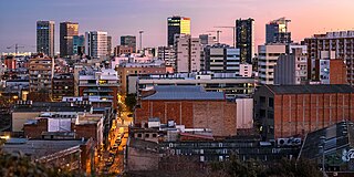
Plaça d'Europa is a square in the District VII of L'Hospitalet de Llobregat suburb of Barcelona, Catalonia in Spain. Located on the Granvia de l'Hospitalet avenue at the intersection with Carrer d'Amadeu Torner. It is part of L'Hospitalet's recent urban development, and one of its biggest squares at 33 ha, with a distinguishable skyline made up of high-rises, among the tallest structures in the city, some of which are designed by the renowned architect Toyo Ito. It is expected to become its economic centre, and will allow different parts of the city formerly severed by the Granvia to become interconnected. It is still not completed but already featuring most of its planned buildings and infrastructure. Part of Fira de Barcelona, near it stand the pavilons of rest of Fira de Barcelona and the shopping centre Gran Via 2.
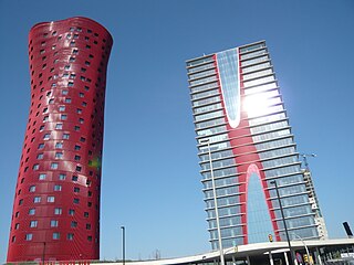
Hotel Porta Fira is a 28-storey, 113 m (371 ft) skyscraper hotel designed by Toyo Ito on the Plaza de Europa in the district of Granvia l'Hospitalet in L'Hospitalet de Llobregat, a suburb of Barcelona, Catalonia, Spain. The building was the 2010 first-place winner of the Emporis Skyscraper Award.
Torre Realia BCN is a skyscraper on the Plaza de Europa in the district of Granvia l'Hospitalet in L'Hospitalet de Llobregat, a city of Barcelones, Catalonia, Spain. Completed in 2009, it has 24 floors and rises 112 meters.

Renaissance Barcelona Fira Hotel, previously Hotel Catalonia Plaza Europa, is a skyscraper and hotel in L'Hospitalet de Llobregat, Catalonia, Spain. Completed in 2011, has 26 floors and rises 105 metres. Lies on the Plaça d'Europa 50. It is part of the Renaissance Hotels group.