
Achill Island is an island off the west coast of Ireland in the historical barony of Burrishoole, County Mayo. It is the largest of the Irish isles and has an area of approximately 148 km2 (57 sq mi). Achill had a population of 2,345 in the 2022 census. The island, which has been connected to the mainland by a bridge since 1887, is served by Michael Davitt Bridge, between the villages of Achill Sound and Polranny. Other centres of population include the villages of Keel, Dooagh, Dooega, Dooniver, and Dugort. There are a number of peat bogs on the island.

County Mayo is a county in Ireland. In the West of Ireland, in the province of Connacht, it is named after the village of Mayo, now generally known as Mayo Abbey. Mayo County Council is the local authority. The population was 137,231 at the 2022 census. The boundaries of the county, which was formed in 1585, reflect the Mac William Íochtar lordship at that time.

The Great Famine, also known as the Great Hunger, the Famine and the Irish Potato Famine, was a period of mass starvation and disease in Ireland lasting from 1845 to 1852 that constituted a historical social crisis and had a major impact on Irish society and history as a whole. The most severely affected areas were in the western and southern parts of Ireland—where the Irish language was dominant—hence the period was contemporaneously known in Irish as an Drochshaol, which literally translates to "the bad life" and loosely translates to "the hard times".

Skibbereen is a town in County Cork, Ireland. It is located in West Cork on the N71 national secondary road. The River Ilen runs through the town; it reaches the sea about 12 kilometres away, at the seaside village of Baltimore. Located in a tourist area, Tragumna beach is nearby.

The Massachusetts Water Resources Authority (MWRA) is a public authority in the Commonwealth of Massachusetts that provides wholesale drinking water and sewage services to 3.1 million people in sixty-one municipalities and more than 5,500 large industrial users in the eastern and central parts of the state, primarily in the Boston area.

Boston Harbor is a natural harbor and estuary of Massachusetts Bay, located adjacent to Boston Massachusetts. It is home to the Port of Boston, a major shipping facility in the Northeastern United States.
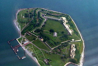
Georges Island is one of the islands in the Boston Harbor, situated just over 7 miles (11 km) from downtown Boston. The island has a permanent size of 39 acres (160,000 m2), plus an intertidal zone of a further 14 acres (57,000 m2), and rises to a height of 50 feet (15 m) above sea level. Historic Fort Warren is on the island. Because of this, and since a ferry operates from Boston to the island, it is a popular destination and one of the easiest islands to access in the Boston Harbor Islands National Recreation Area.

Peddocks Island is one of the largest islands in Boston Harbor. Since 1996 it has formed part of the Boston Harbor Islands National Recreation Area. Managed by the Department of Conservation and Recreation, the island is home to the now-defunct Fort Andrews, active in harbor defense from 1904 to the end of World War II, on its eastern end, and a group of privately owned cottages on its western end. Campsites are also on the eastern end. Ferry service between Peddocks Island and Georges Island is provided on a seasonal basis.

Moon Island is an island in Quincy Bay, in the middle of Boston Harbor, Massachusetts, United States. It is the location of the Boston Fire Department Training Academy, and Boston Police Department shooting range. All of the land on the island is owned by the City of Boston but the island is under the jurisdiction of Quincy, Massachusetts. It is also part of the Boston Harbor Islands National Recreation Area.

Calf Island, also known as Apthorps Island, is an island situated some 9 miles (14 km) offshore of downtown Boston in Boston Harbor Islands National and State Park. The island has a permanent size of 18 acres (73,000 m2), plus an intertidal zone of a further 16 acres (65,000 m2).

Long Island is located in Boston Harbor, Massachusetts. The island is part of the City of Boston, and of the Boston Harbor Islands National Recreation Area. The island is 1.75 miles (2.82 km) long and covers 225 acres (0.9 km2).

Deer Island is a peninsula in Boston, Massachusetts, United States. Since 1996, it has been part of the Boston Harbor Islands National and State Park. Although still an island by name, Deer Island has been connected to the mainland since the former Shirley Gut channel, which once separated the island from the town of Winthrop, Massachusetts, was filled in by the 1938 New England hurricane. Today, Deer Island is the location of the Deer Island Wastewater Treatment Plant, whose 150-foot-tall (46 m) egg-like sludge digesters are major harbor landmarks.

The Deer Island Waste Water Treatment Plant is located on Deer Island, one of the Boston Harbor Islands in Boston Harbor. The plant is operated by the Massachusetts Water Resources Authority (MWRA) and began partial operations in 1995. The facility was fully operational in 2000 with the completion of the outfall tunnel.

Armando David Mazzone served for twenty-six years as a United States district judge of the United States District Court for the District of Massachusetts.
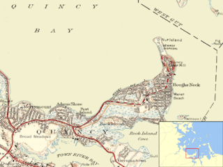
Nut Island is a former island in Boston Harbor, part of the Boston Harbor Islands National Recreation Area. The island has been connected through a short causeway to the end of Houghs Neck, becoming part of the mainland of Quincy, Massachusetts.

The Irish Commemorative Stone is a monument in Pointe-Saint-Charles, island of Montreal, Quebec commemorating the deaths from "ship fever" (typhoid) of 6,000 mostly Irish immigrants to Canada during the immigration following the Great Irish Famine in the years 1847-1848.
The South Boston CSO Storage Tunnel, also known as the North Dorchester Bay CSO Storage Tunnel, is a large underground facility designed to reduce untreated sewage discharges into Boston Harbor from the Massachusetts Water Resources Authority combined sewer and stormwater system. It was opened on July 23, 2011, and is part of the federally mandated Boston Harbor Cleanup project. CSO stands for Combined Sewer Overflow.

The Irish Famine Memorial, or An Gorta Mor 'Irish Famine and Emigration,' also known as the Irish Famine Monument, is a memorial in Cambridge, Massachusetts, United States.

The Western New York Irish Famine Memorial is a memorial to The Great Famine. Situated on La Riviere Street along the waterfront in Buffalo, New York, it was dedicated in 1997. It was designed by Rob Ferguson and was erected by the Western New York Famine Commemoration Committee. The memorial consists of a central piece of granite. At its base there is an inscription of Luke 19:40 in Irish. The stone is situated in a well, meant to represent "The Great Silence," during which time very few people were willing to speak about the famine. Along its outer ring are 32 boulders, meant to represent the 32 counties of Ireland. There are also stones inscribed with the names of those who survived the Famine. Some stones are left blank, representing the unknown dead.
