| Look up Great North Road in Wiktionary, the free dictionary. |
Great North Road may refer to:
| Look up Great North Road in Wiktionary, the free dictionary. |
Great North Road may refer to:
Transport in New Zealand, with its mountainous topography and a relatively small population mostly located near its long coastline, has always faced many challenges. Before Europeans arrived, Māori either walked or used watercraft on rivers or along the coasts. Later on, European shipping and railways revolutionised the way of transporting goods and people, before being themselves overtaken by road and air, which are nowadays the dominant forms of transport. However, bulk freight still continues to be transported by coastal shipping and by rail transport, and there are attempts to (re)introduce public transport as a major transport mode in the larger population centres.

Mesa Verde National Park is an American national park and UNESCO World Heritage Site located in Montezuma County, Colorado. The park protects some of the best-preserved Ancestral Puebloan archaeological sites in the United States.
The New Zealand state highway network is the major national highway network in New Zealand. Nearly 100 roads in the North and South Islands are state highways. All state highways are administered by the NZ Transport Agency.

A kiva is a space used by Puebloans for rites and political meetings, many of them associated with the kachina belief system. Among the modern Hopi and most other Pueblo people, kivas are a large room that is circular and underground, and are used for spiritual ceremonies.

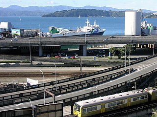
The Auckland Harbour Bridge is an eight-lane motorway bridge over the Waitematā Harbour in Auckland, New Zealand. It joins St Marys Bay on the Auckland city side with Northcote on the North Shore side. It is part of State Highway 1 and the Auckland Northern Motorway. The bridge is operated by the NZ Transport Agency (NZTA). It is the second-longest road bridge in New Zealand, and the longest in the North Island.

The Great South Road was the northern section of the earliest highway between Auckland and Wellington, in the North Island of New Zealand.
Transport in Auckland, New Zealand's largest city, is defined by factors that include the shape of the Auckland isthmus, the suburban character of much of the urban area, a history of focusing investment on roading projects rather than public transport, and high car-ownership rates.

Great North Road is a major thoroughfare in Auckland, in the North Island of New Zealand. It runs from the fringe of the Auckland CBD to west Auckland. The road is the second longest in Auckland, after its counterpart, Great South Road. In the days before the Auckland Harbour Bridge, Northern Motorway and Northwestern Motorway were built, it was the main road route from central Auckland to the areas north of the Auckland isthmus. In the 1960s, it carried 25,000–30,000 vehicles a day.
A halfway house is a community-release institution for prisoners

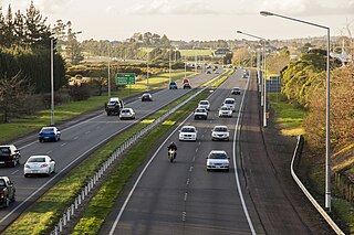
The Auckland Northern Motorway in the Auckland Region of New Zealand links central Auckland City and Puhoi in the former Rodney District via the Hibiscus Coast and North Shore. It is part of State Highway 1.
The Auckland Southern Motorway is the major route south out of the Auckland Region of New Zealand. It is part of State Highway 1.

The Northwestern Motorway, part of State Highway 16 (SH16), is the major western route and secondary northern route out of Auckland in New Zealand. Twenty-one kilometres in length, the motorway runs from Stanley St in Parnell through the Central Motorway Junction, and west through urban Auckland and Waitakere before continuing northwest and terminating outside of Kumeu. Its western terminus is at Brigham Creek Road in Whenuapai. A large part of it forms the middle section of the Western Ring Route.
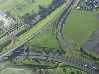
State Highway 20 (SH 20), also known as the Southwestern Motorway, is a New Zealand state highway linking State Highway 1 at Manukau with State Highway 16 in Point Chevalier, via Māngere and Onehunga. Along with its spurs, State Highway 20A and 20B, the state highway serves Auckland Airport, the country's largest, therefore making SH 20 a key arterial route connecting the airport to the wider Auckland region and most of the upper North Island. The route also forms the southern part of the Western Ring Route, a 48 kilometres (30 mi) motorway route bypassing central Auckland.

Horseshoe Canyon, formerly known as Barrier Canyon, is in a remote area west of the Green River and north of the Canyonlands National Park Maze District in Utah, United States. It is known for its collection of Barrier Canyon Style (BCS) rock art, including both pictographs and petroglyphs, which was first recognized as a unique style here. A portion of Horseshoe Canyon containing The Great Gallery is part of a detached unit of Canyonlands National Park. The Horseshoe Canyon Unit was added to the park in 1971 in an attempt to preserve and protect the rock art found along much of its length.

The Lowry Pueblo is an Ancestral Puebloan archaeological site located in Canyons of the Ancients National Monument near Pleasant View, Colorado, United States. The pueblo was constructed around 1060 AD atop abandoned pithouses from an earlier period of occupation. It was occupied by 40 to 100 people at a time for 165 years. The site is one of the northernmost to be associated with the Puebloan cultures. The site was declared a National Historic Landmark in 1964.
The Eastern Line is the name of the suburban rail service in Auckland, New Zealand between Britomart and Manukau via the North Island Main Trunk (NIMT) and Manukau Branch. Services are operated by Transdev under the AT brand.
The Marsden Point Branch is a 19 km (12 mi) branch line railway, which is to be built in the Northland Region of New Zealand's North Island. It will diverge from the North Auckland Line at Oakleigh, south of Whangārei, and serve Northport at Marsden Point. The proposal has existed since the 1970s and land for the rail corridor is being actively purchased. In October 2017, the new Labour–NZ First coalition government announced that it would spend $600 million on rehabilitating the North Auckland Line and building the branch at a cost of $200 million, the total works to cost $800 million. In June 2021 it was announced that the line would be built and was expected to take about 5 years.

The Trail of the Ancients is a National Scenic Byway located in the states of Colorado and Utah. The route highlights the archaeological and cultural history of southwestern Native American peoples, and traverses the widely diverse geological landscape of the Four Corners region of the Colorado Plateau. It was the first National Scenic Byway that was designated solely for its archaeological sites. The entire route is approximately 480 miles (772.5 km) long.
Auckland Light Rail is a proposed light rail line in Auckland, the largest city in New Zealand.

The Ancestral Puebloans, also known as the Anasazi, were an ancient Native American culture that spanned the present-day Four Corners region of the United States, comprising southeastern Utah, northeastern Arizona, northwestern New Mexico, and southwestern Colorado. They are believed to have developed, at least in part, from the Oshara Tradition, which developed from the Picosa culture. The people and their archaeological culture are often referred to as Anasazi, meaning "ancient enemies", as they were called by Navajo. Contemporary Puebloans object to the use of this term, with some viewing it as a derogatory term.