Cape to Cairo Road

Last updated

Schild TAH4.svg
Cape to Cairo Road
Cairo-Cape Town Highway Map.png
Location
Highway system
The Rhodes Colossus: Caricature of Cecil Rhodes, after he announced plans for a telegraph line and railroad from Cape Town to Cairo. Punch Rhodes Colossus.png
The Rhodes Colossus : Caricature of Cecil Rhodes, after he announced plans for a telegraph line and railroad from Cape Town to Cairo.
Map showing almost complete British control of the Cape to Cairo route, 1914

.mw-parser-output .legend{page-break-inside:avoid;break-inside:avoid-column}.mw-parser-output .legend-color{display:inline-block;min-width:1.25em;height:1.25em;line-height:1.25;margin:1px 0;text-align:center;border:1px solid black;background-color:transparent;color:black}.mw-parser-output .legend-text{}
British control Colonial Africa 1913 map.svg
Map showing almost complete British control of the Cape to Cairo route, 1914
  British control

The Cape to Cairo Road or Pan-African Highway, sometimes called the Great North Road in sub-Saharan Africa, was a proposed road that would stretch the length of Africa, from Cape Town to Cairo, through the Cape to Cairo Red Line of British colonies. The proposal was similar to the Cape to Cairo Railway, another proposed infrastructure project through the same colonies. Neither were completed before British colonial rule ended in the colonies.

Contents

In the 1980s the plan was revived with modifications as the Cairo–Cape Town Highway , known as Trans-African Highway 4, in the transcontinental road network being developed by the United Nations Economic Commission for Africa (UNECA), the African Development Bank (ADB), and the African Union, as part of the Trans-African Highway network. While it uses most of the same roads as the original Cape to Cairo Road, it uses different routes in a few places.

History

The original proposal for a North South Red Line route was made in 1874 by Edwin Arnold, then the editor of The Daily Telegraph , which was joint sponsor of the expedition by H.M. Stanley to Africa to discover the course of the Congo River. [1] The proposed route involved a mixture of railway and river transport between Elizabethville, now Lubumbashi in the Belgian Congo and Sennar in the Sudan rather than a completely rail one. [2]

In comparison, the Red Line road would stretch across the continent from south to north, running through the British colonies of the time, such as the Union of South Africa, Southern and Northern Rhodesia and Nyasaland, Kenya, Sudan and Egypt. The road would create cohesion between the British colonies of Africa, it was thought, and give Britain the most important and dominant political and economic influence over the continent, securing its position as a global colonial power. The road would also link some of the most important cities on the continent, including Cape Town, Johannesburg, Pretoria, Harare (then Salisbury), Lusaka (the main street through the centre of Lusaka was part of this route and is how it got its name, Cairo Road), Nairobi, Khartoum and Cairo. One of the main proponents of the route was Cecil John Rhodes, though his preference was for a railway. [3] German East Africa (Tanganyika, now Tanzania) was a gap in the British territories, but Rhodes, in particular, felt that Germany ought to be a natural ally. Shortly before his death he had persuaded the German Kaiser to allow access through his colony for the Cape to Cairo telegraph line (which was built as far north as Ujiji but never completed). [4] In 1918 Tanganyika became British and the gap in territories was filled.

One of the biggest problems was the decline of the Empire and fragmentation of the British colonies. Even though Egypt became independent in 1922, British influence there was strong enough for Cairo to be viewed as part of the British sphere of interest,[ citation needed ] and the idea of a road continued. After Egypt, Sudan was the next to become independent in 1956,[ citation needed ] putting an end to the colonial motivation of the dream.

France had a rival strategy in the late 1890s to link its colonies from west to east across the continent, Senegal to Djibouti. Southern Sudan and Ethiopia were in the way, but France sent expeditions in 1897 to establish a protectorate in southern Sudan and to find a route across Ethiopia. The scheme foundered when a British flotilla on the Nile confronted the French expedition at the point of intersection between the French and British routes, leading to the Fashoda Incident and eventual diplomatic defeat for France.

The first known attempt to drive a vehicle from Cape Town to Cairo was by a Captain Kelsey in 1913-14 but this came to an untimely end when he was killed by a leopard in Rhodesia. The first successful journey was Court Treatt expedition of 1924 led by Major Chaplin Court Treatt and described by his wife Stella Court Treatt in Cape to Cairo (1927), which drove two Crossley light trucks leaving Cape Town on 23 September 1924 and arriving in Cairo on 24 January 1926. [5] [6]

The original route today

Starting from the south, the first section of the road that runs through South Africa is called the N1, linking Cape Town in the south with Beit Bridge on the Limpopo River between South Africa and Zimbabwe. It passes through Johannesburg and Pretoria. There are numerous alternative routes in South Africa.

In Zimbabwe, the road continues from Beit Bridge as the Chirundu-Beitbridge Regional Road Corridor, which consists of the A4 road (R1 road) to Harare and the A1 road (R3 road) to Chirundu Border Post on the Zambezi River thereafter, continuing as the T2 Road in Zambia to Lusaka. An alternative route is the A6 and A8 roads, which connect the South African Border with the Zambian Border at Victoria Falls on the Zambezi River via Bulawayo. The alternative route continues as the T1 Road in Zambia towards Lusaka.

From Lusaka, Zambia's Great North Road continues the route to Tanzania as the T2 Road. (Also known as the Tanzam Highway and consisting of a right turn at Kapiri Mposhi towards Tanzania)

In Tanzania there are a number of roads could be deemed to be part of the route, the clear definitions and markings that are characteristic of the Pan-African Highway do not apply here. Most would consider it to be the road from Tunduma on the Tanzania-Zambia border, through Iringa and Morogoro to the Arusha turnoff at Chalinze, and north to Arusha (although there is now a shorter route from Iringa to Arusha through Dodoma and Babati), then to Nairobi in Kenya. This route is now all paved. There was a marker in the 1930s in Arusha, Tanzania, to indicate the midpoint of the road. [7]

Kenya has a tarred highway to its border with Sudan but the roads in southern Sudan are very poor and made frequently impassable, so that even without the conflicts that have afflicted Sudan, the route through Ethiopia is generally preferred by overland travellers. Also, the border between Sudan and South Sudan was closed in 2011, expected to be reopened in 2022. [8] [9] The route from Isiolo in Kenya to Moyale on the Ethiopian border through the northern Kenyan desert has sometimes been dangerous due to bandits, but is now paved.

Through Ethiopia the route is tarred but some sections may have deteriorated severely. A paved road from Lake Tana to Gedaref takes the route into Sudan. [10] [11]

The most difficult section in the whole Cape to Cairo journey was across the Nubian Desert in northern Sudan between Atbara and Wadi Halfa, but this has been bypassed by a paved road on the west side of the Nile, Dongola to Abu Simbel Junction to Aswan. [12] [ better source needed ] Tarred highways continue the route to Cairo.

Cairo–Cape Town Highway

The Cairo–Cape Town Highway is Trans-African Highway 4 in the transcontinental road network being developed by the United Nations Economic Commission for Africa (UNECA), the African Development Bank (AfDB), and the African Union. The route has a length of 10,228 km (6,355 mi) [13] and also links Cairo in Egypt to Cape Town in South Africa.

Schild TAH4.svg
Trans-African Highway 4
Cairo-Cape Town Highway Map.png
Route information
Length10,228 km (6,355 mi)
Major junctions
North endSchild TAH1.svg TAH 1 in Cairo, Egypt
Major intersectionsSchild TAH6.svg TAH 6 in Sudan and Ethiopia
Schild TAH8.svg TAH 8 in Nairobi, Kenya
Schild TAH9.svg TAH 9 in Zambia
South endSchild TAH3.svg TAH 3 in Cape Town, South Africa
Location
Highway system
Schild TAH3.svg TAH 3 Schild TAH5.svg TAH 5

Background

The Cairo–Cape Town Highway follows much of the Cape-to-Cairo Road's route but it has a few differences.

Firstly, the Cairo–Cape Town Highway passes through Addis Ababa, Ethiopia while the original Cape-to-Cairo Road goes directly through South Sudan from Kenya. Secondly, the Cairo–Cape Town Highway in Southern Africa passes through Livingstone (Victoria Falls), Bulawayo, Francistown and Gaborone and not through Harare, Pretoria and Johannesburg. Thirdly, the Cairo–Cape Town Highway in Tanzania passes as the shortcut through Dodoma and Babati when travelling from Iringa to Arusha and not as the longer route through Chalinze.

This new route has a length of 10,228 km (6,355 mi). [13]

The modern revival of the plan occurred in the 1980s. South Africa was not originally included in the route which was first planned in the Apartheid era, but it is now recognized that it would continue into that country. The consultants' report suggested Pretoria as end, which seems somewhat arbitrary and as a major port, Cape Town, is regarded as the southern end of regional highways in Southern African Development Community countries. The highway may be referred to in documents as the Cairo–Gaborone Highway or Cairo–Pretoria Highway.[ citation needed ]

Route

The stretch of highway between Dongola and Wadi Halfa in Northern Sudan and the Egypt-Sudan border are now accessible by road through the Qastal-Ashkeet border post.

Between Wad Madani in Sudan and Wereta in Ethiopia, the route is shared with the Ndjamena-Djibouti Highway. The Ethiopian section is all tarmac road, although much of the Ethiopian section passes through mountainous terrain and parts of the road may be hazardous as a result.

In northern Kenya the section has been hazardous due to the activities of armed bandits. [14] The road has been dubbed "Hell's Road" by overland travellers, [14] but it is completely paved. In Nairobi, the Cairo-Cape Town Highway intersects with the Lagos–Mombasa Highway.

Sceneries between Iringa and Dodoma. Iringa - Dodoma Road Sceneries.jpg
Sceneries between Iringa and Dodoma.

The road section through Babati and Dodoma to Iringa in central Tanzania (the T2 Road) has been completely paved, and passable throughout most of the year.

Between Iringa in Tanzania and Kapiri Mposhi in Zambia via Tunduma & Mpika, the highway uses an important regional route, the Tanzam Highway. This highway used to have the distinction of being the only link between any of Africa's five major regions which is paved, linking East Africa to Southern Africa. It is the most used of any such inter-regional road on the continent.[ citation needed ] The Tanzanian section is designated as the T1 Road while the Zambian section is called the Great North Road (T2 Road).

From Kapiri Mposhi, the road is completely paved, mostly in good condition and continues southwards as the T2 Road (still called Great North Road), through Kabwe and Lusaka to the Kafue River Bridge, where it becomes the south-westerly Lusaka–Livingstone Road, through Mazabuka and Choma to Livingstone and the Victoria Falls, where the road crosses the Zambezi River and enters Zimbabwe. The section from Kapiri Mposhi to the beginning of the Lusaka-Livingstone Road south of Kafue is shared with the Beira-Lobito Highway.

The road section through Zimbabwe is paved, firstly going south-east from Victoria Falls to Bulawayo as the A8 Road, then shifting south-west as the A7 Road, crossing the border with Botswana after Plumtree (Ramokgwebana River), to the city of Francistown. The road section through Botswana is paved, going from the border with Zimbabwe as one road (the A1 Road) through Francistown, Palapye, Gaborone and Lobatse to the Ramatlabama border with South Africa.

In South Africa, the road is completely paved, first going south from the Ramatlabama Border through Mahikeng to Warrenton as the N18 Route, then from Warrenton through Kimberley to Beaufort West as the N12 Route, then from Beaufort West to Cape Town as the N1 Route. At Cape Town, it meets the southern terminus of the Tripoli–Cape Town Highway, where it ends.

See also

Related Research Articles

Transport in Tanzania includes road, rail, air and maritime networks. The road network is 86,472 kilometres (53,731 mi) long, of which 12,786 kilometres (7,945 mi) is classified as trunk road and 21,105 kilometres (13,114 mi) as regional road. The rail network consists of 3,682 kilometres (2,288 mi) of track. Commuter rail service is in Dar es Salaam only. There are 28 airports, with Julius Nyerere International being the largest and the busiest. Ferries connect Mainland Tanzania with the islands of Zanzibar. Several other ferries are active on the countries' rivers and lakes.

This article is about the transport in Zambia.

<span class="mw-page-title-main">TAZARA Railway</span> Railway in Tanzania and Zambia

The Tazara Railway, also called the Uhuru Railway or the Tanzam Railway, is a railway in East Africa linking the port of Dar es Salaam in east Tanzania with the town of Kapiri Mposhi in Zambia's Central Province. The single-track railway is 1,860 km (1,160 mi) long and is operated by the Tanzania-Zambia Railway Authority (TAZARA).

<span class="mw-page-title-main">Zambia Railways</span> National railway company of Zambia

Zambia Railways (ZR) is the national railway company of Zambia, one of the two major railway organisations in Zambia. The other system is the binational TAZARA Railway (TAZARA) that interconnects with the ZR at Kapiri Mposhi and provides a link to the Tanzanian port of Dar es Salaam.

<span class="mw-page-title-main">Kapiri Mposhi</span> Town in Central, Zambia

Kapiri Mposhi is a Zambian town, seat of the Kapiri Mposhi District, Central Province. Located north of Lusaka, it stands on the Great North Road and is significant for the railway connection between Zambia Railways line from Kitwe to Lusaka and Livingstone and western terminal of the Tanzania-Zambia Railway Authority from Dar es Salaam since 1976.

<span class="mw-page-title-main">Cape to Cairo Railway</span> Proposed but never completed railway connecting British colonies in eastern Africa

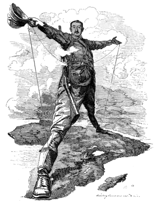
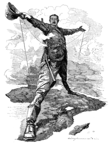
The Cape to Cairo Railway was an unfinished project to create a railway line crossing Africa from south to north. It would have been the largest and most important railway of that continent. It was planned as a link between Cape Town in South Africa and Port Said in Egypt.

<span class="mw-page-title-main">Walvis Bay-Ndola-Lubumbashi Development Road</span> Road in Southern Africa

The Walvis Bay-Ndola-Lubumbashi Development Road runs from Walvis Bay, through Rundu in north eastern Namibia, along the Caprivi Strip to Katima Mulilo on the Zambezi River, which forms the border between Namibia and Zambia. The Katima Mulilo Bridge spans the river to the Zambian town of Sesheke from where a recently upgraded paved road runs to Livingstone joining the main north–south highway to Lusaka, connecting onwards to the Copperbelt.

<span class="mw-page-title-main">Great North Road, Zambia</span> Road in Zambia

The Great North Road is a major route in Zambia, running north from Lusaka through Kabwe, Kapiri Mposhi, Serenje, Mpika, Kasama, Mbala and Mpulungu. 82km North of Mpika is a signposted right turn onto a well maintained gravel road leading to Shiwa Ng'andu (12km) and Kapishya Hot Springs (32km). The road from Zambia's border with Zimbabwe at Chirundu to Lusaka is now regarded as being part of the Great North Road; but this is only since the opening of the Chirundu Bridge in 1939 - before that, the Great North Road ran from Livingstone to Lusaka, as part of the original Cape to Cairo Red Line by Cecil John Rhodes. The portion from Mbala to Mpulungu could be regarded as a spur linking to the Lake Tanganyika steamer service which was popular with travellers up to the 1950s.

<span class="mw-page-title-main">Mpika</span> Town in Zambia

Mpika is a town in the Muchinga Province of Zambia, lying at the junction of the M1 Road to Kasama and Mbala and the Tanzam Highway to Dar es Salaam, Tanzania in the north-east and Lusaka in the south-west. It also has a railway station on the TAZARA Railway about 5 kilometres (3 mi) away. Mpika is situated between the Muchinga Escarpment to the east and vast miombo plains to the west. The town has an estimated population of 40,000 inhabitants (2008), while the district population is estimated at 150,000 inhabitants. Since Mpika District was the biggest district in Zambia before its division in 2017, the population density was less than 4 people per square kilometre.

<span class="mw-page-title-main">Trans-Sahara Highway</span> Highway across the Sahara Desert in Africa

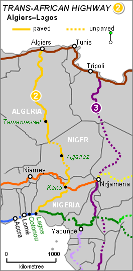
The Trans-Sahara Highway or TAH 2 is a proposed transnational highway project to pave, improve and ease border formalities on an existing trade route running north–south across the Sahara Desert. It runs between North Africa bordered by the Mediterranean Sea in the north and West Africa bordered by the Atlantic Ocean in the south, from Algiers in Algeria to Lagos in Nigeria, giving it the alternative names of the Algiers–Lagos Highway or Lagos–Algiers Highway.

<span class="mw-page-title-main">Trans-African Highway network</span> Transcontinental roads project in Africa

The Trans-African Highway network comprises transcontinental road projects in Africa being developed by the United Nations Economic Commission for Africa (UNECA), the African Development Bank (ADB), and the African Union in conjunction with regional international communities. They aim to promote trade and alleviate poverty in Africa through highway infrastructure development and the management of road-based trade corridors. The total length of the nine highways in the network is 56,683 km (35,221 mi).

The Ndjamena-Djibouti Highway or TAH 6 is Trans-African Highway 6 in the transcontinental road network being developed by the United Nations Economic Commission for Africa (UNECA), the African Development Bank (ADB), and the African Union, connecting the Sahelian region to the Indian Ocean port of Djibouti in the country of Djibouti.

<span class="mw-page-title-main">Beira–Lobito Highway</span>

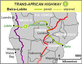
The Beira–Lobito Highway or TAH 9 is Trans-African Highway 9 in the transcontinental road network being developed by the United Nations Economic Commission for Africa (UNECA), the African Development Bank (ADB), and the African Union. The route has a length of 3,523 km (2,189 mi) crossing Angola, the most southerly part of the Democratic Republic of the Congo, Zambia, Zimbabwe, and central Mozambique.

<span class="mw-page-title-main">Cairo–Cape Town Highway</span> Transcontinental road network

The Cairo–Cape Town Highway is Trans-African Highway 4 in the transcontinental road network being developed by the United Nations Economic Commission for Africa (UNECA), the African Development Bank (AfDB), and the African Union. The route has a length of 10,228 km (6,355 mi) and links Cairo in Egypt to Cape Town in South Africa.

Stella Maud Court Treatt, FRGS was a South African filmmaker, author, and adventurer who with her first husband Chaplin Court Treatt undertook the Court Treatt Expedition 1924–1926, the first successful attempt to drive a motor car from Cape Town to Cairo.

Nakonde is a town in the Muchinga Province of Zambia, on the border with Tanzania. It is at the northern end of Zambia's Great North Road. It is the principal commercial and political headquarters of Nakonde District and the district headquarters are located here.

<span class="mw-page-title-main">T2 road (Zambia)</span> Road in Zambia

The T2 is a trunk road in Zambia. The road runs from the Tunduma border with Tanzania via Mpika, Kabwe and Lusaka to the Chirundu border with Zimbabwe. The road is the longest route of the country, as it is approximately 1,155 kilometres (718 mi). The entire route is a toll road.

<span class="mw-page-title-main">T3 road (Zambia)</span> Road in Zambia

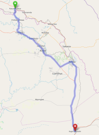
The T3 is a Trunk Road in Zambia. The road runs from Kapiri Mposhi via Ndola, Kitwe and Chingola to Kasumbalesa on the border with DR Congo. The entire route is a toll road.

<span class="mw-page-title-main">Tanzam Highway</span> Highway from Lusaka, Zambia to Dar es Salaam, Tanzania

The Tanzam Highway leads from Lusaka in Zambia to Dar es Salaam in Tanzania. The highway was built from 1968 to 1973 in several stages and was intended to provide seaport access for Zambia and to expand the transport options for Zambia, Malawi and the then Zaire.

The M1 Road is a road in northern Zambia. It connects Mpika in Muchinga Province with Mbala in the Northern Province on the border with Tanzania and the Mpulungu port of Lake Tanganyika via Kasama. The northern section is a toll road.

References

  1. K J Panton, (2015). "A Historical Dictionary of the British Empire", Lanham, Rowman & Littlefield, p. 113. ISBN   978-0-81087-801-3.
  2. Weinthal, Leo (20 February 1923). "The story of the Cape to Cairo railway and river route from 1887 to 1922; the iron spine and ribs of Africa". London, Pioneer Pub. Co via Internet Archive.
  3. "Cape to Cairo Railway".
  4. Denny, S. R. (1962). "The Cape to Cairo Telegraph". The Northern Rhodesia Journal. 5 (1): 39–42. Retrieved 15 April 2007 via NRZAM.
  5. Court Treatt, Stella (1927). Cape to Cairo. London: Harrap.
  6. "The Court Treatt Expedition" . Retrieved 22 May 2009.
  7. Matson Photo Service (1936). "Tanganyika. Arusha. Half-way point from Cape to Cairo, 1936" (Photograph) via Library of Congress.
  8. Malak, Garang A. (22 August 2021). "South Sudan: Sudan, South Sudan to Reopen Borders After 11 Years". allAfrica.com. Retrieved 5 July 2022.
  9. "Kiir lauds S.Sudan-Sudan border reopening". Sudan Tribune. 8 June 2022. Retrieved 6 July 2022.
  10. Michelin Maps. 745 Africa North East & Arabia (Map). 1:4,000,000.[ full citation needed ]
  11. Michelin Maps. 746 Africa Central & South, Madagascar (Map). 1:4,000,000.[ full citation needed ]
  12. "Sudan to Egypt via Argeen (west of Nile)". Horizons Unlimited. 23 May 2017.
  13. 1 2 "Cairo-Cape Town Highway: From Vision to Reality in 2015". Egyptian Streets. ES Media. 12 September 2014. Retrieved 25 January 2015.
  14. 1 2 de Vos, Bas (20 May 2016). "Our ride to Kenya's Hell and back – for a cold beer". Business Day Live. Retrieved 21 May 2016.

Bibliography

  • African Development Bank; United Nations Economic Commission For Africa (14 August 2003). "Volume 2: Description of Corridors" (PDF). Review of the Implementation Status of the Trans African Highways and the Missing Links. Archived from the original (PDF) on 28 January 2007. Retrieved 14 July 2007.
  • Michelin Maps (2000). "Africa Central and South" (Map). Michelin Motoring and Tourist Map. Paris: Michelin Travel Publications.[ full citation needed ]