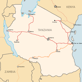
Transport in Tanzania includes road, rail, air and maritime networks. The road network is 86,472 kilometres (53,731 mi) long, of which 12,786 kilometres (7,945 mi) is classified as trunk road and 21,105 kilometres (13,114 mi) as regional road. The rail network consists of 3,682 kilometres (2,288 mi) of track. Commuter rail service is in Dar es Salaam only. There are 28 airports, with Julius Nyerere International being the largest and the busiest. Ferries connect Mainland Tanzania with the islands of Zanzibar. Several other ferries are active on the countries' rivers and lakes.
This article is about the Transport in Zambia.

Iringa is a city in Tanzania with a population of 202,490 and situated at a latitude of 7.77°S and longitude of 35.69°E. The name is derived from the Hehe word lilinga, meaning fort. Iringa is the administrative capital of Iringa Region. Iringa Municipal Council is the administrative designation of the Municipality of Iringa. Iringa has been one of the coldest regions in Tanzania due to its geographical location but that has attracted a lot of tourists from colder regions abroad especially Western Europe. Iringa also hosts one of Africa’s largest national parks the Ruaha National Park.

The Tazara Railway, also called the Uhuru Railway or the Tanzam Railway, is a railway in East Africa linking the port of Dar es Salaam in east Tanzania with the town of Kapiri Mposhi in Zambia's Central Province. The single-track railway is 1,860 km (1,160 mi) long and is operated by the Tanzania-Zambia Railway Authority (TAZARA).

Zambia Railways (ZR) is the national railway company of Zambia and one of the two major railway organisations in Zambia. The other system is the binational TAZARA Railway (TAZARA) that interconnects with the ZR at Kapiri Mposhi and provides a link to the Tanzanian port of Dar es Salaam.

Kapiri Mposhi is a Zambian town and the seat of the Kapiri Mposhi District in Central Province. Located north of Lusaka, it stands on the Great North Road and is significant for the railway connection between the Zambia Railways line from Kitwe to Lusaka and the western terminus of the Tanzania-Zambia Railway Authority from Dar es Salaam since 1976.

Mbeya is a city located in south west Tanzania, Africa, with an urban population of 649,000 in 2023. Mbeya is the capital of the surrounding rural Mbeya region.

The Great North Road is a major route in Zambia, running north from Lusaka through Kabwe, Kapiri Mposhi, Serenje, Mpika, Isoka and Nakonde to the border with Tanzania. The entire route is designated as the T2 road on Zambia's road network. It forms the Zambian section of the Tanzam Highway.

Mpika is a town in the Muchinga Province of Zambia, lying at the junction of the M1 Road to Kasama and Mbala and the Tanzam Highway to Dar es Salaam, Tanzania in the north-east and Lusaka in the south-west. It also has a railway station on the TAZARA Railway about 5 kilometres (3 mi) away. Mpika is situated between the Muchinga Escarpment to the east and vast miombo plains to the west. The town has an estimated population of 40,000 inhabitants (2008), while the district population is estimated at 150,000 inhabitants. Since Mpika District was the biggest district in Zambia before its division in 2017, the population density was less than 4 people per square kilometre.

Mbarali District is one of the five districts of Mbeya Region, Tanzania. It is bordered to the north by Iringa region and east by Njombe region. To the south the district is bordered by Mbeya District and to the west by Chunya District.
Rail transport in Zambia is primarily provided by two systems:
Railway stations in Tanzania include:

The Cairo–Cape Town Highway is Trans-African Highway 4 in the transcontinental road network being developed by the United Nations Economic Commission for Africa (UNECA), the African Development Bank (AfDB), and the African Union. The route has a length of 10,228 km (6,355 mi) and links Cairo in Egypt to Cape Town in South Africa.
Makambako is a medium-sized town and district in the Njombe Region of the Tanzanian Southern Highlands, located roughly 40 miles north of Njombe city by road. It is located at junction of the A104 and B4 roads between Njombe, Iringa, and Mbeya. Its population according to the 2002 Tanzanian census was 51,049.

The Port of Dar es Salaam is the principal port serving Tanzania located in Kurasini ward of Temeke District of Dar es Salaam Region. The port is one of three ocean ports in the country and handles over 90% of the country's cargo traffic. According to the International Association of Ports and Harbors, it is the fourth largest port on the African continent's Indian Ocean coastline after Durban, Mombasa and Maputo. The port acts as a gateway for commerce and trade for Tanzania and numerous bordering landlocked states.
Chilonga is a town in Mpika District in the Muchinga Province of Zambia.
Nakonde is a town in the Muchinga Province of Zambia, on the border with Tanzania. It is at the northern end of Zambia's Great North Road. It is the principal commercial and political headquarters of Nakonde District and the district headquarters are located here.

The T2 is a trunk road in Zambia. The road runs from the Tunduma border with Tanzania via Mpika, Kabwe and Lusaka to the Chirundu border with Zimbabwe. The road is the longest route of the country, as it is approximately 1,155 kilometres (718 mi). The route from Mpika to Kafue is a toll road. The route from Tanzania to Lusaka is Zambia's Great North Road and is part of the Tanzam Highway.
The M1 road is a road in northern Zambia. It connects Mpika in Muchinga Province with Mbala in the Northern Province on the border with Tanzania and the Lake Tanganyika port of Mpulungu via Kasama. The northern section is a toll road.
The Lobito–Dar es Salaam Railway is a planned narrow gauge railway line that connects the Angolan port city of Lobito to the Tanzanian port city of Dar es Salaam, through the Zambian city of Kapiri Mposhi. It is an African transcontinental railroad connecting the Atlantic and Indian oceans and it is financed by China. The initiative is planned in tandem with the country's US$10 billion standard-gauge railway infrastructure development, to help Tanzania secure port business from Rwanda, Burundi, Uganda, and the Democratic Republic of Congo (DRC).

