This article is about the Transport in Zambia.

The Brooker Highway is a highway in the Australian state of Tasmania. As one of Hobart's three major radials, the highway connects traffic from the city centre with the northern suburbs and is the major road connection to the cities and towns of northern Tasmania. With an annual average daily traffic of 48,000, the highway is one of the busiest in Tasmania. The Brooker Highway has recently been declared part of the National Highway.

The A426 road is a road in England which runs from the city of Leicester to the market town of Southam in Warwickshire via the towns of Lutterworth and Rugby.

Kafue is a town in the Lusaka Province of Zambia and it lies on the north bank of the Kafue River, after which it is named. It is the southern gateway to the central Zambian plateau on which Lusaka and the mining towns of Kabwe and the Copperbelt are located. It is located on the T2 Road.

The Walvis Bay-Ndola-Lubumbashi Development Road runs from Walvis Bay, through Rundu in north eastern Namibia, along the Caprivi Strip to Katima Mulilo on the Zambezi River, which forms the border between Namibia and Zambia. The Katima Mulilo Bridge spans the river to the Zambian town of Sesheke from where a recently upgraded paved road runs to Livingstone joining the main north–south highway to Lusaka, connecting onwards to the Copperbelt.

The Great North Road is a major route in Zambia, running north from Lusaka through Kabwe, Kapiri Mposhi, Serenje, Mpika, Isoka and Nakonde to the border with Tanzania. The entire route is designated as the T2 road on Zambia's road network. It forms the Zambian section of the Tanzam Highway.

The Great East Road is a major road in Zambia and the main route linking its Eastern Province with the rest of the country. It is also the major link between Zambia and Malawi and between Zambia and northern Mozambique. However, the route does not carry as much traffic as many of the other regional arterial roads and between the main cities it serves, Lusaka and Chipata, it passes through rural and wilderness areas. In Lusaka the road forms the main arterial road for the eastern suburbs. The entire route from Lusaka to Chipata and the Malawi Border Post is designated the T4 Road on Zambia's road network.
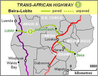
The Beira–Lobito Highway or TAH 9 is Trans-African Highway 9 in the transcontinental road network being developed by the United Nations Economic Commission for Africa (UNECA), the African Development Bank (ADB), and the African Union. The route has a length of 3,523 km (2,189 mi) crossing Angola, the most southerly part of the Democratic Republic of the Congo, Zambia, Zimbabwe, and central Mozambique.
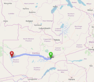
The Lusaka–Mongu Road of Zambia runs 580 km from the capital, Lusaka, to Mongu, capital of the Western Province. It connects that province to the rest of the country, as well as being one of two routes to the south-west extremity of North-Western Province. It also serves as the main highway of the western half of Central Province. The entire route from Lusaka to Mongu is designated as the M9 Road.

The T1 or Lusaka–Livingstone Road is the main highway of the Southern Province of Zambia. It begins 55 kilometres south of the city of Lusaka and heads south-west to the principal tourist destination, Victoria Falls in Livingstone, via Mazabuka, Monze, Choma and Kalomo, measuring approximately 430 kilometres (267 mi). The entire route is part of Trans-African Highway network number 4 or Cairo-Cape Town Highway between Cairo and Cape Town.

Chilanga is a township located 20 km south of Zambia's capital city, Lusaka. It is situated midway between Lusaka and Kafue on the T2 road.
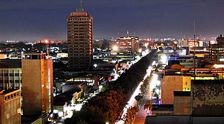
Lusaka is the capital and largest city of Zambia. It is one of the fastest-developing cities in southern Africa. Lusaka is in the southern part of the central plateau at an elevation of about 1,279 metres (4,196 ft). As of 2019, the city's population was about 3.3 million, while the urban population is estimated at 2.5 million in 2018. Lusaka is the centre of both commerce and government in Zambia and connects to the country's four main highways heading north, south, east, and west. English is the official language of the city administration, while Bemba, Tonga, Lenje, Soli, Lozi, and Nyanja are the commonly spoken street languages.

The Cairo–Cape Town Highway is Trans-African Highway 4 in the transcontinental road network being developed by the United Nations Economic Commission for Africa (UNECA), the African Development Bank (AfDB), and the African Union. The route has a length of 10,228 km (6,355 mi) and links Cairo in Egypt to Cape Town in South Africa.
East-West Link is a proposed road tunnel in Brisbane, Queensland, Australia. It forms the fifth and final component of Brisbane City Council's TransApex plan to connect motorways across the city, construct new river crossings and divert cross-city traffic out of the Brisbane CBD.

The T2 is a trunk road in Zambia. The road runs from the Tunduma border with Tanzania via Mpika, Kabwe and Lusaka to the Chirundu border with Zimbabwe. The road is the longest route of the country, as it is approximately 1,155 kilometres (718 mi). The route from Mpika to Kafue is a toll road. The route from Tanzania to Lusaka is Zambia's Great North Road and is part of the Tanzam Highway.
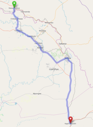
The T3 is a Trunk Road in Zambia. The road runs from Kapiri Mposhi via Ndola, Kitwe and Chingola to Kasumbalesa on the border with DR Congo. The route is a toll road from Kapiri Mposhi to just after Kitwe.
The M4 Road is a road in the Copperbelt Province of Zambia. The Road connects the city of Ndola with the city of Mufulira. The route extends to connect Mufulira with the city of Kitwe. As it is a v-shaped route, the M4 Road starts and ends at a junction with the T3 Road.
The M11 Road is a road in the Southern Province of Zambia that connects Choma with Namwala. It is the main road connecting Namwala to the rest of the Southern Province. It is approximately 169 kilometres in length.
The M18 Road is a road in Zambia that connects Kitwe in the Copperbelt Province with Kasempa in the North-Western Province via Kalulushi and Lufwanyama. It is the only other road after the T5 Road that connects the towns of the North-Western and Copperbelt provinces. The section from Kitwe to Kalulushi is designated as the M7 Road while the remainder of the route from Kalulushi westwards is designated as the M18 Road on Zambia's road network.
The M16 is a short 14-kilometre toll road in Kalulushi District, Copperbelt Province, Zambia that connects Kalulushi with Sabina.


