Magnetawan

Last updated

Magnetawan
Municipality of Magnetawan
Magnetawan ON 2.JPG
Magnetawan on the Magnetawan River
Canada Southern Ontario location map 2.png
Red pog.svg
Magnetawan
Coordinates: 45°40′N79°38′W / 45.667°N 79.633°W / 45.667; -79.633
CountryCanada
Province Ontario
District Parry Sound
Settled1870s
IncorporatedJanuary 1, 1998
Government
  TypeTownship
  MayorSam Dunnett
  Federal riding Parry Sound-Muskoka
  Prov. riding Parry Sound—Muskoka
Area
[1]
  Land526.31 km2 (203.21 sq mi)
Population
 (2021) [1]
  Total1,753
  Density3.3/km2 (9/sq mi)
Time zone UTC-5 (EST)
  Summer (DST) UTC-4 (EDT)
Postal Code
P0A
Area code 705
Website magnetawan.com OOjs UI icon edit-ltr-progressive.svg

Magnetawan is a township in the Almaguin Highlands region of the Parry Sound District in the Canadian province of Ontario, as well as the name of the primary population centre in the township.

Contents

The Township of Magnetawan was formed in 1998 through the amalgamation of the Township of Chapman and the Village of Magnetawan, along with the unincorporated geographic Townships of Croft and Spence.

The word Magnetawan in the Algonquin language means "swiftly flowing river." [2]

Barbara Hanley, the first woman ever elected mayor of a community in Canada, was born in Magnetawan in 1882.

Magnetawan is the setting for The Rogue Hunter, the tenth book in the popular Urban Fantasy Argeneau series by Ontario-born author Lynsay Sands.

The community is twinned with the city of Baltimore, Maryland.[ citation needed ]

History

The first people to inhabit the region were the Hurons, Ojibway and Algonquins, who would visit the area in the summer for hunting and fishing but sheltered on Georgian Bay in the winter. While some Europeans explored the region in the early 19th century, settlement and colonization by Europeans was hardly taking place, so much so that the government considered turning the entire region into an Indian reserve. [3]

But when pine stands in southern Ontario became depleted, the area attracted loggers and the government changed its mind and encouraged settlement through free land grants, first offered in 1853. Settlement happened slowly but accelerated when the colonization road from Rosseau to Nipissing began being built in 1866. [3] In 1868, the government passed the Free Grand Land and Homestead Act and began advertising this extensively in European countries to attract new immigrants. [4] Croft Township was surveyed in 1869, Chapman Township in 1870, and the village of Magnetawan was mapped out in 1873. [5]

The Great North Road, from Parry Sound to Nipissing, reached the Magnetawan at Ahmic Harbour in 1870. [6] The 76 miles (122 km) stretch of the colony road from Rousseau to Nipissing reached the Magnetawan in 1874, where the historic village of Magnetawan was built. [6] In 1879 a pair of small steamships started carrying cargo and passengers over the 20 miles (32 km) reach from the rapids at the village upstream to Burk's Falls.

Burk's Falls was linked to the south by a railroad in 1885. [6] A lock was completed, enabling navigation west of the rapids at the historic village of Magnetawan, in 1886. Following its completion larger steamships started carrying cargo and passengers, and towing log booms, over the reach from Burk's Falls to Ahmic Harbour. During its first 25 years of operation the lock-keeper recorded steamships transited the lock 17,590 times. The last steamship, a tugboat used to tow log-booms, used the river in 1934.
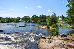
Geography

Core rock samples done by Walfried Schwerdtner in the surrounding area, show mostly foliated Grenville Gneiss. [7]

Communities

Ahmic Harbour Ahmic Harbour ON.jpg
Ahmic Harbour

The township comprises the communities of Ahmic Harbour, Ahmic Lake, Cecebe, Cedar Croft, Chikopi, Dufferin Bridge, Magnetawan, North Seguin, Oranmore, Pearceley, Port Anson and Port Carmen, as well as the ghost town of Spence.

Lakes and rivers

Demographics

In the 2021 Census of Population conducted by Statistics Canada, Magnetawan had a population of 1,753 living in 825 of its 1,717 total private dwellings, a change of 26.1% from its 2016 population of 1,390. With a land area of 526.31 km2 (203.21 sq mi), it had a population density of 3.3/km2 (8.6/sq mi) in 2021. [1]

Canada census – Magnetawan community profile
2021 2016 2011
Population1,753 (+26.1% from 2016)1,390 (-4.4% from 2011)1,454 (-9.7% from 2006)
Land area526.31 km2 (203.21 sq mi)531.53 km2 (205.22 sq mi)531.83 km2 (205.34 sq mi)
Population density3.3/km2 (8.5/sq mi)2.6/km2 (6.7/sq mi)2.7/km2 (7.0/sq mi)
Median age59.2 (M: 59.2, F: 59.2)57.4 (M: 56.6, F: 58.1)54.3 (M: 54.6, F: 54.1)
Private dwellings1,717 (total)  825 (occupied)1,698 (total) 1,782 (total) 
Median household income$67,000$54,336
References: 2021 [9] 2016 [10] 2011 [11] earlier [12] [13]
Magnetawan historical populations
YearPop.±%
1996 1,324    
2001 1,342+1.4%
2006 1,610+20.0%
2011 1,454−9.7%
2016 1,390−4.4%
2021 1,753+26.1%
Source: Statistics Canada [14]
Municipal office and library of Magnetawan Magnetawan ON 1.JPG
Municipal office and library of Magnetawan

Prior to amalgamation (1998):

Mother tongue (2021): [1]

Attractions

Magnetawan is a historic village with a surrounding municipality that provides various attractions. From the museum to the picturesque waters, are all a part of this municipality. The downtown used to consist of a restaurant named The Magnetawan Inn, also June's Inn, as well as a small hotel/bar, and a General Store. In the summer of 2011, on July 30, the General Store burned down taking part of the Magnetawan Inn with it. [15]

General Store in town until 2011 Downtown General Store.jpg
General Store in town until 2011

In the downtown, there is now a brand new general store/restaurant built between 2012 and 2013. Also, there is a museum, Lions Pavilion Park, farmers market, little shops, locks/dams, and a LCBO store. In the village, there is a school, churches, golf course named Ahmic Lake Golf Club, post office, a library, the municipality offices, and the municipality pavilion. [16] Magnetawan is also home to many resorts and rentable cottages. Two of the biggest resorts are Woodland Echoes and Ahmic Lake Resort, where the Swiss Country House Restaurant is located.

Following is a list of unique characteristics about this town. [17]

See also

Related Research Articles

<span class="mw-page-title-main">Unorganized South Nipissing District</span> Unorganized area in Ontario, Canada

Unorganized South Nipissing District is an unorganized area in north-central Ontario, in the District of Nipissing. It is almost entirely within and includes most of Algonquin Provincial Park.

<span class="mw-page-title-main">Parry Sound District</span> District in Ontario, Canada

Parry Sound District is a census division of the Canadian province of Ontario. Its boundaries are District of Muskoka to the south, the Sudbury District to the north-northwest, the French River and Lake Nipissing in the north, Nipissing District and North Bay in the north and east and parts of Algonquin Park in the northeast.

<span class="mw-page-title-main">Unorganized Centre Parry Sound District</span> Unorganized area in Ontario, Canada

Unorganized Centre Parry Sound District is an unorganized area in central Ontario, Canada, between Georgian Bay and Lake Nipissing in the District of Parry Sound. It is made up of geographic townships which have no governing bodies and which are not incorporated as municipalities. The territory consists of two non-contiguous areas, with the main part located directly south of the French River and Lake Nipissing, and east of Georgian Bay. Shawanaga Township is a small exclave south of it along Highway 69.

<span class="mw-page-title-main">Nipissing District</span> District in Ontario, Canada

Nipissing District is a district in Northeastern Ontario in the Canadian province of Ontario. It was created in 1858. The district seat is North Bay.

<span class="mw-page-title-main">Burk's Falls</span> Village in Ontario, Canada

Burk's Falls is an incorporated village in the Almaguin Highlands region of Parry Sound District, Ontario, Canada, located 265 kilometres (165 mi) north of Toronto and 90 kilometres (56 mi) south of North Bay, Ontario. The village, and the waterfall on the site, were named by David Francis Burk of Oshawa, after he selected the land surrounding the waterfall in the Free Land Grant Act. Burk's Falls is part of the Magnetawan River waterway.

<span class="mw-page-title-main">Magnetawan River</span> River in Ontario, Canada

The Magnetawan River is a long river in Parry Sound District, Ontario, Canada. The river flows 175 km from its source of Magnetawan Lake inside Algonquin Provincial Park to empty into Georgian Bay at the community of Britt on Byng Inlet.

<span class="mw-page-title-main">Bonfield, Ontario</span> Township in Ontario, Canada

Bonfield is a township in northeastern Ontario, Canada, on the Mattawa River in Nipissing District.

<span class="mw-page-title-main">Callander, Ontario</span> Canadian township established 1891

The Municipality of Callander is a township in central Ontario, Canada, located at the southeast end of Lake Nipissing in the Almaguin Highlands region of the District of Parry Sound. The municipality is located on Callander Bay, just south of North Bay.

<span class="mw-page-title-main">Nipissing, Ontario</span> Township in Ontario, Canada

Nipissing is an incorporated (political) township in Parry Sound District in Central Ontario, Canada. It is on Lake Nipissing and is part of the Almaguin Highlands region. Nipissing was surveyed between 1874 and 1881, and was incorporated in 1888. Among the first settlers in the area were the Chapman and Beatty families. Nipissing Township annexed Gurd Township in 1970. The township also contains a community named Nipissing, which is located on the South River near Chapman's Landing, on the South Bay of Lake Nipissing. The township administrative offices are located in Nipissing.

Kearney is a town and municipality in the Almaguin Highlands region of Parry Sound District of Ontario, Canada. With a landmass of 528 square kilometres and a year-round population of 974 in the Canada 2021 Census, Kearney claims to be the "Biggest Little Town in Ontario."

<span class="mw-page-title-main">Ahmic Lake</span> A lake in Ontario, Canada

Ahmic Lake is a lake in Parry Sound District, Ontario, Canada, part of the Magnetawan River waterway in the Almaguin Highlands region. Ahmic Lake is approximately 19 km long and connects to two smaller lakes, Neighick and Crawford Lake.

<span class="mw-page-title-main">South River, Ontario</span> Village in Ontario, Canada

South River is a village on Highway 124 near Algonquin Park in the Almaguin Highlands region of Parry Sound District of Ontario, Canada. It is about halfway between North Bay and Huntsville or a 3-hour drive (300 km) north from Toronto. South River has access to the Algonquin Park for canoeists at Kawawaymog. South River is home of Mikisew Provincial Park on the shores of Eagle Lake.

King's Highway 124, commonly known as Highway 124, is a provincially maintained highway in the Canadian province of Ontario. The highway connects Highway 400 in Parry Sound with Highway 11 in Sundridge, a distance of 91.2 km (56.7 mi), including a 15.4 km (9.6 mi) concurrency with Highway 520. It is one of several highways in Central Ontario to provide this connection through the Muskoka and Parry Sound region, and the northernmost provincial highway to do so south of Highway 17.

<span class="mw-page-title-main">Whitestone, Ontario</span> Municipality in Ontario, Canada

Whitestone is a municipality in the Canadian province of Ontario, as well as the name of a community within the municipality.

<span class="mw-page-title-main">Armour, Ontario</span> Township municipality in Ontario, Canada

Armour is a township municipality in the Canadian province of Ontario.

<span class="mw-page-title-main">Strong, Ontario</span> Township in Ontario, Canada

Strong is a township in the Canadian province of Ontario, as well as the name of a community within the township. Located in the Almaguin Highlands region of Parry Sound District, the township surrounds but does not include the village of Sundridge.

<span class="mw-page-title-main">South Algonquin</span> Township municipality in Ontario, Canada

South Algonquin is a township municipality in Nipissing District, Ontario, Canada. Located south of Algonquin Provincial Park, it is the sole populated portion of the district that lies south of the traditional dividing line between Northern Ontario and Southern Ontario and is closer connected to Renfrew County as opposed to the core portions of Nipissing District.

Lake Cecebe is a lake in the Almaguin Highlands region of the Parry Sound District, Ontario, Canada. Lake Cecebe is part of the Magnetawan River waterway. The lake has over 20 miles of shoreline. The village of Burk's Falls is located upstream of Lake Cecebe on the Magnetawan River and the historic village of Magnetawan, Ontario is located where the river exits Lake Cecebe and flows into Ahmic Lake.

<span class="mw-page-title-main">Almaguin Highlands</span> Inter-region in Ontario, Canada

The Almaguin Highlands Region in Ontario, Canada, covers approximately 5,200 km2 (2,000 sq mi) comprising the eastern half of Parry Sound District. It is bounded by Muskoka in the south, and by Lake Nipissing and Nipissing District in the north. The eastern edge abuts the western boundary of Algonquin Provincial Park, whereas the western boundary of the Almaguin Highlands is generally regarded to be the mid east-west point of Parry Sound District. Originally derived from the words Algonquin, Magnetawan, and Seguin. the name Almaguin is now used to describe the marketing region of East Parry Sound.

<i>Kawigamog</i>

The Kawigamog was a steamship that carried passengers and all kinds of cargo on the Pickerel River, a tributary of the French River, that drains Lake Nipissing into Georgian Bay, in Ontario.

References

  1. 1 2 3 4 "Census Profile, 2021 Census Magnetawan, Municipality". Statistics Canada. Retrieved February 9, 2022.
  2. "Magnetawan Ontario". Almaguin Highlands Ontario Inc. Retrieved June 27, 2019.
  3. 1 2 "Aborginals[sic] Hurons, Ojibway and Algonquins". Municipality of Magnetawan. Archived from the original on 2011-07-14. Retrieved 2010-08-24.
  4. "The Land Grants". Municipality of Magnetawan. Retrieved 2010-08-24.
  5. Elise von Koerber, native of Baden-Baden, since 1872 appointed immigration agent by the federal government of Canada. She brought several hundred German-speaking Swiss citizens to Magnetawan. French-speaking persons mostly went to the Doe Lake. In 1881, about 200 Swiss remained in this region.
  6. 1 2 3 Astrid Taim (2016). "Astrid Taim's Almaguin Chronicles 2-Book Bundle: Almaguin / Almaguin Chronicles". Dundurn Press. ISBN   9781459737006 . Retrieved 2018-09-08.
  7. Schwerdtner, W (2008). "Structure of Ahmic domain and its vicinity, southwestern Central Gneiss Belt, Grenville Province of Ontario (Canada)". Precambrian Research. 167 (1–2): 16–34. Bibcode:2008PreR..167...16S. doi:10.1016/j.precamres.2008.07.002.
  8. Fox, M. G. (1993). "A comparison of zygote survival of native and non-native walleye stocks in two Georgian Bay rivers". Environmental Biology of Fishes. 38 (4): 379–383. doi:10.1007/BF00007532. S2CID   21652235.
  9. "2021 Community Profiles". 2021 Canadian Census . Statistics Canada. February 4, 2022. Retrieved 2023-10-19.
  10. "2016 Community Profiles". 2016 Canadian Census . Statistics Canada. August 12, 2021. Retrieved 2018-02-18.
  11. "2011 Community Profiles". 2011 Canadian Census . Statistics Canada. March 21, 2019. Retrieved 2014-02-25.
  12. "2006 Community Profiles". 2006 Canadian Census . Statistics Canada. August 20, 2019.
  13. "2001 Community Profiles". 2001 Canadian Census . Statistics Canada. July 18, 2021.
  14. 1996, 2001, 2006, 2011, 2016, 2021
  15. Learn, Rob (August 1, 2011). "Magnetawan mourns fiery loss". Huntsville Forester. Metroland Media Group. Retrieved June 27, 2019.
  16. "Let's get started". Magnetawan and Area Businesses. Retrieved June 27, 2019.
  17. "Local Attractions". Municipality of Magnetawan. Retrieved June 27, 2019.
  18. "Echo Beach Cottage Resort" . Retrieved June 27, 2019.
  19. "Camp Kahquah" . Retrieved February 24, 2014.