Related Research Articles

Sudbury, officially Greater Sudbury, is a city in Ontario, Canada. It is the largest city in Northern Ontario by population, with a population of 161,531 at the 2016 Canadian Census. By land area, it is the largest in Ontario and the fifth largest in Canada. It is administratively a unitary authority and thus is not part of any district, county, or regional municipality. The City of Greater Sudbury is separate from but entirely surrounded by Sudbury District.

The Sudbury District is a district in Northeastern Ontario in the Canadian province of Ontario. It was created in 1894 from townships of eastern Algoma District and west Nipissing District.

Nobel is a village on the shores of Parry Sound, Ontario, Canada. It is in the Municipality of McDougall in the District of Parry Sound. The community is named after Alfred Nobel, the inventor of dynamite.

Nickel Centre was a town in Ontario, Canada, which existed from 1973 to 2000.
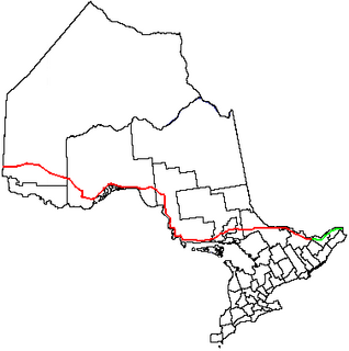
King's Highway 17, more commonly known as Highway 17, is a provincially maintained highway and the primary route of the Trans-Canada Highway through the Canadian province of Ontario. It begins at the Manitoba boundary, 50 km (31 mi) west of Kenora, and the main section ends where Highway 417 begins just west of Arnprior. A small disconnected signed section of the highway still remains within the Ottawa Region between County Road 29 and Grants Side Rd. This makes it Ontario's longest highway.
French River, also known as Rivière-des-Français, is a municipality in the Canadian province of Ontario, in the Sudbury District. The municipality had a population of 2,662 in the Canada 2016 Census. It was formed in 1999 through the merger of the Township of Cosby, Mason and Martland and surrounding unincorporated portions of the Unorganized North Sudbury District. It was named after the French River, which flows through the municipality.
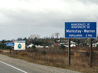
Markstay-Warren is a town in the Canadian province of Ontario, located in the Sudbury District. Highway 17, from the city limits of Greater Sudbury to the Sudbury District's border with Nipissing District, lies entirely within Markstay-Warren. The town had a population of 2,656 in the Canada 2016 Census.
King's Highway 69, commonly referred to as Highway 69, is a provincially maintained north–south highway in the central portion of the Canadian province of Ontario. In conjunction with Highway 400, it links Toronto with the city of Greater Sudbury at Highway 17, via Parry Sound. It is part of the Trans-Canada Highway and the National Highway System. From its southern terminus of Highway 559 at Carling, Highway 69 begins as Highway 400 narrows from a four-laned freeway to a two lane highway. It travels northerly for approximately 68 kilometres (42 mi) to south of the French River before widening back to a divided four lane freeway for approximately 64 kilometres (40 mi) into Sudbury. The final 6 kilometres (3.7 mi) of the route, connecting to Highway 17, is a five lane arterial road that will be converted to freeway as the final phase of the four-laning.

Unorganized North Algoma District is an unorganized area in northeastern Ontario, Canada, comprising all areas in Algoma District, north of the Sault Ste. Marie to Elliot Lake corridor, which are not part of an incorporated municipality or a First Nation. It covers 44,077.03 km2 (17,018.24 sq mi) of land, and had a population of 5739 in 2016.
King's Highway 64, commonly referred to as Highway 64, is a provincially maintained highway in the Canadian province of Ontario, connecting Highway 69 north of the French River with Highway 11 at Marten River, via Highway 17 west of Sturgeon Falls. The route serves several communities along the north shore of the French River and west shore of Lake Nipissing as it travels from Highway 69 to Highway 17. North of Sturgeon Falls, the highway provides a shortcut between Highway 17 and Highway 11 northwest of North Bay.
Secondary Highway 537, commonly referred to as Highway 537, is a provincially maintained secondary highway in the Canadian province of Ontario. The highway is 16.1 kilometres (10.0 mi) in length, connecting Highway 69 near Wanup with Finni Road. It once continued 3.6 km (2.2 mi) further to intersect Highway 17 in Wahnapitae, but was truncated in 1998; this portion of the route is now designated as Greater Sudbury Municipal Road 537. Highway 537 remains the only secondary highway in the province within a jurisdiction that also maintains a county/regional road network.

Northeastern Ontario is a secondary region of Northern Ontario in the Canadian province of Ontario, which lies north of Lake Huron and east of Lake Superior.
Wahgoshig First Nation, formerly known as Abitibi-Ontario Band of Abitibi Indians or simply as Abitibi, is an Anishinaabe and Cree First Nation band governments whose reserve communities are located near Matheson in Cochrane District in northeastern Ontario, Canada. They have reserved for themselves the 7,770.1 hectares Abitibi Indian Reserve No. 70 on the south end of Lake Abitibi. In January 2008, the First Nation had 270 people registered with the nation, of which their on-reserve population was 121.
King's Highway 169, commonly referred to as Highway 169, was a provincially maintained highway in the Canadian province of Ontario. The highway connected Highway 12 at Brechin, southeast of Orillia, with Highway 69 at Foot's Bay. The 91.40 km (56.79 mi) route included an 18.20 km (11.31 mi) concurrency with Highway 11 between Washago and Gravenhurst. Located within Simcoe County and the District Municipality of Muskoka, the highway also provided access to the community of Bala.
Black Lake is a Denesuline First Nations band government in the boreal forest of northern Saskatchewan, Canada. It is located on the northwest shore of Black Lake where the Fond du Lac River leaves the lake to flow to Lake Athabasca.
The Naicatchewenin First Nation, also known as the Anishinaabeg of Nagaajiwanaang and formerly known as Northwest Bay First Nation, inhabited a region in Ontario that was cited in the Northwest Angle Treaty of 1873, also known as Treaty 3. Nagaajiwanaang is located approximately 60 kilometres (37 mi) northwest of Fort Frances, with the community of Devlin 50 kilometres (31 mi) to the south on Highway 11. The city of Thunder Bay lies 420 kilometres (260 mi) to the east and Winnipeg is 450 kilometres (280 mi) to the northwest.
Secondary Highway 529, commonly referred to as Highway 529, is a provincially maintained secondary highway in the Canadian province of Ontario. Located within Parry Sound District, the highway follows a 25.7-kilometre (16.0 mi) route, from its southern terminus at Highway 69 near Pointe au Baril to its northern terminus at the Highway 69 crossing of the Magnetawan River near Byng Inlet. Two spur routes, Highway 529A and Highway 645, branch off the highway to serve the communities of Bayfield Inlet and Byng Inlet, respectively. The route was established along the present alignment of Highway 529A in 1956. It was relocated in 1961 along the former routing of Highway 69 when a bypass opened through the area, with the former alignment being renumbered as Highway 529A.
Wallbridge is an unorganized geographic township in Parry Sound District, Ontario, Canada. Part of the census subdivision of Unorganized Centre Parry Sound District, the township includes the communities of Britt, Byng Inlet and Harris Lake and the rail sidings of Drocourt and North Magnetawan. Although not an incorporated municipality, Britt and Byng Inlet are jointly served by a local services board.
References
- ↑ Olivia Stefanovich, "Shawanaga First Nation 'prepared to deal' with Ontario government on Highway 69 widening". CBC News Sudbury, August 17, 2017.
| Towns |  | |
|---|---|---|
| Townships | ||
| Villages | ||
| First Nations | ||
| Indian reserves | ||
| Local services boards | ||
| Unorganized areas | ||
| | This First Nations in Canada-related article is a stub. You can help Wikipedia by expanding it. |