Joly | |
|---|---|
| Township of Joly | |
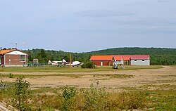 South River-Sundridge District Airport | |
 Joly | |
| Coordinates: 45°47′N79°15′W / 45.783°N 79.250°W | |
| Country | Canada |
| Province | Ontario |
| District | Parry Sound |
| Settled | 1880s |
| Incorporated | 1890 |
| Government | |
| • Type | Township |
| • Mayor | Brian McCabe |
| • Fed. riding | Parry Sound-Muskoka |
| • Prov. riding | Parry Sound—Muskoka |
| Area | |
| • Land | 193.95 km2 (74.88 sq mi) |
| Population (2021) [1] | |
• Total | 293 |
| • Density | 1.5/km2 (3.9/sq mi) |
| Time zone | UTC-5 (EST) |
| • Summer (DST) | UTC-4 (EDT) |
| Postal Code | P0A |
| Area codes | 705, 249 |
| Website | www |
Joly is a township in the Almaguin Highlands region of Parry Sound District of the Canadian province of Ontario.
Contents
The township has no named communities within its boundaries; all addresses in the township are rural routes assigned to the adjacent communities of South River, Sundridge, Hartfell or Pevensey. The South River-Sundridge District Airport is in Joly.
