
Madawaska County, also known as the "New Brunswick Panhandle", is located in northwestern New Brunswick, Canada. Over 90% of the county's population speaks French. Its Francophone population are known as "Brayons." Forestry is the major industry in the county.

Northumberland County is located in northeastern New Brunswick, Canada.
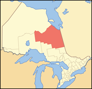
Cochrane District is a district and census division in Northeastern Ontario in the Canadian province of Ontario. It was created in 1921 from parts of Timiskaming and Thunder Bay districts.

Thunder Bay District is a district and census division in Northwestern Ontario in the Canadian province of Ontario. The district seat is Thunder Bay.

Le Haut-Saint-Laurent(Upper Saint Lawrence) is a regional county municipality in southwestern Quebec, Canada, in the Montérégie region. Its seat is in Huntingdon. It is named for the Saint Lawrence River, which forms its western and its northwestern boundaries.

Papineauville is a town and municipality in the Outaouais region of Quebec, Canada. It is the seat of the Papineau Regional County Municipality. In 2001 its population was 2247.
The Aamjiwnaang First Nation is an Anishinaabe (Ojibwe) First Nations Band located on reserve land by the St. Clair River in Ontario, Canada, three miles south of the southern tip of Lake Huron. The reserve is located across from the United States border from Port Huron, Michigan, and is a result of treaties that were negotiated with the Crown in the 1820s. There are approximately 2,000 band members with about 850 living on the reserve. Their heritage language is Ojibwe.

Plaisance is a municipality in Papineau Regional County Municipality in western Quebec, Canada. The village is situated on the Ottawa River near the mouth of the Petite-Nation River, 70 km from Gatineau and 160 km from Montreal on Route 148.

Timiskaming is a First Nations reserve in the Abitibi-Témiscamingue region of Quebec, Canada, just north of the head of Lake Timiskaming. It belongs to the Timiskaming First Nation, an Algonquin band. It is geographically within the Témiscamingue Regional County Municipality but administratively not part of it.
La Romaine, also known as Unamenshipit in Innu-aimun, is an Innu First Nations reserve in the Côte-Nord region of Quebec, Canada, at the mouth of the Olomane River on the Gulf of Saint Lawrence. It belongs to the Innu band of Unamen Shipu. Being an enclave within the Municipality of Côte-Nord-du-Golfe-du-Saint-Laurent, it is geographically within Le Golfe-du-Saint-Laurent Regional County Municipality but administratively not part of it. Directly adjacent to the reserve is the community of La Romaine consisting of a small French-speaking population.
Brudenell, Lyndoch and Raglan is a township in Renfrew County, Ontario, Canada. It was formed on January 1, 1999, through the merger of Brudenell and Lyndoch Township with Raglan Township.

Lake of the Woods is a township in the Canadian province of Ontario, located within the Rainy River District. The township is located on the eponymous Lake of the Woods, consisting of mainland in the south-east part of the lake, the southern shores of Aulneau Peninsula, along with several islands in the lake, including Big Island and Bigsby Island. It fully surrounds the Anishnaabeg of Naongashiing, Big Grassy River 35G, Big Island Mainland 93, and Saug-a-Gaw-Sing 1 First Nation reserves.

Mashteuiatsh is a First Nations reserve in the Saguenay–Lac-Saint-Jean region of Quebec, Canada, about 6 kilometres (3.7 mi) north from the centre of Roberval. It is the home to the Pekuakamiulnuatsh First Nation. It is located on a headland jutting out on the western shores of Lake Saint-Jean known as Pointe-Bleue, in the geographic township of Ouiatchouan, and belongs to the Montagnais du Lac St-Jean Innu band. It is geographically within the Le Domaine-du-Roy Regional County Municipality but administratively not part of it.
Dokis 9 is a First Nations reserve and community in the Canadian province of Ontario, assigned to the Dokis First Nation. The reserve is located approximately 16 kilometers southwest of central southern Lake Nipissing along the French River. It is divided into two large parts consisting of a north island, Okikendawt, and a large southern peninsula. The two land masses, which are nestled within the flows of the French river, covers 154.36 square kilometers. The French River watershed in Northern Ontario was created more than ten thousand years ago when the last ice-age receded and left a maze of rivers and small lakes. The main settlement is found on Okikendawt island which can be accessed by a gravel road which connects with Highway 64. The Land is occupied by the Dokis and its cousin tribe, the Restoule‘s. The land is well known for its hunting, fishing, fur trades, and timber.
Saugeen 29 is a First Nations reserve in Bruce County, Ontario. It is the main reserve of the Saugeen First Nation.

Kitigan Zibi is a First Nations reserve of the Kitigan Zibi Anishinabeg First Nation, an Algonquin band. It is situated near the confluence of the Désert and Gatineau Rivers, and borders south-west on the Town of Maniwaki in the Outaouais region of Quebec, Canada. Having a total area of 210.09 km2 (81.12 sq mi), it is the largest Algonquin Nation in Canada in both area and population.

Notre-Dame-du-Laus is a municipality in the Laurentides region of Quebec, Canada, part of the Antoine-Labelle Regional County Municipality.

Wemotaci is a First Nations reserve on the north shore of the Saint-Maurice River at the mouth of the Manouane River in the Mauricie region of Quebec, Canada. Together with the Obedjiwan and the Coucoucache Indian Reserve No. 24, it belongs to the Atikamekw First Nation.

Manawan, officially named communauté Atikamekw de Manawan, is a First Nations reserve on the south-western shores of Lake Métabeskéga in the Lanaudière region of Quebec, Canada. It belongs to the Atikamekw of Manawan band of the Atikamekw Nation.

Henvey Inlet 2 is a First Nations reserve in Parry Sound District, Ontario, on the northeastern shore of Georgian Bay. It is one of two reserves of the Henvey Inlet First Nation.

