Powassan

Last updated

Powassan
Municipality of Powassan
Powassan welcome sign.jpeg
Canada Southern Ontario location map 2.png
Red pog.svg
Powassan
Coordinates: 46°04′57″N79°21′43″W / 46.08250°N 79.36194°W / 46.08250; -79.36194
Country Canada
Province Ontario
District Parry Sound District
Established1904 (original boundaries)
2001 (current boundaries)
Government
  TypeTown
  MayorPeter McIsaac [1]
  Governing BodyMunicipality of Powassan Council
   MP Anthony Rota  (L)
   MPP Vic Fedeli  (PC)
Area
[2]
  Total223.26 km2 (86.20 sq mi)
Population
 (2021) [2]
  Total3,346
  Density15.0/km2 (39/sq mi)
Time zone UTC-5 (EST)
  Summer (DST) UTC-4 (EDT)
Postal code span
P0H
Area code 705
Website www.powassan.net

Powassan is a municipality in the Canadian province of Ontario, located near North Bay. Powassan is located in the Almaguin Highlands region of Parry Sound District, at its easternmost boundary with the Nipissing District.

Contents

The municipality includes the population centres of Powassan and Trout Creek, both along Highway 11.

History

Taken from a First Nations name that means "bend", Powassan's original settlement was at the bend of the South River. The location today is known as the Bingham Chute, and is where the present hydro plant is. The village of Powassan began in/about 1880 with the construction of a sawmill and a grist mill. Mill employees built their houses in that section of the village.

Countryside in Powassan Powassan ON.JPG
Countryside in Powassan
Trout Creek Trout Creek ON.JPG
Trout Creek

A construction camp for the Northern and Pacific Junction Railway was established at Powassan in 1885. This section of track completed in 1886, was taken over by the Grand Trunk Railway in 1888 and absorbed by Canadian National Railways in 1923.

In 1886, the operation of the Northern and Pacific Junction Railway between Gravenhurst and Nipissing Junction saw the development of a second settlement near the railroad. Christopher Armstrong and William Faulkner Clark were granted two lots by the Crown, lots 15 and 16, respectively, in the 12th concession of the Township of Himsworth. The 15th sideroad of the Township of Himsworth was the road allowance reserve between the two lots, which is the present-day Main Street, Powassan's main thoroughfare. Armstrong divided lot 15 into sections that were 1/5 of an acre in size; Clark divided lots into lots of 1/4 acre each. Clark's plans are registered as numbers 43 and 57. [3]

On November 30, 1904, a Royal Proclamation was issued that declared that Powassan was a separate and new municipality. In the same proclamation, the citizens were constituted a body corporate under the name of the Corporation of the Town of Powassan. In 1906, the present town hall was built.

Powassan virus , a tick-borne disease, is named after the town of Powassan, where it was identified in a 5-year-old boy who died from encephalitis in 1958. [4] [5]

The current Municipality of Powassan came into being on January 1, 2001 as a result of the amalgamation of the Town of Powassan, Town of Trout Creek and the Township of South Himsworth. The two main communities in the town are Powassan and Trout Creek.

Climate

Climate data for Powassan (1981−2010)
MonthJanFebMarAprMayJunJulAugSepOctNovDecYear
Record high °C (°F)13.0
(55.4)
14.5
(58.1)
20.6
(69.1)
31.0
(87.8)
32.2
(90.0)
34.0
(93.2)
36.0
(96.8)
34.5
(94.1)
31.5
(88.7)
27.5
(81.5)
18.9
(66.0)
17.5
(63.5)
36.0
(96.8)
Mean daily maximum °C (°F)−6.9
(19.6)
−4.3
(24.3)
1.3
(34.3)
9.8
(49.6)
17.6
(63.7)
22.5
(72.5)
24.9
(76.8)
23.4
(74.1)
18.4
(65.1)
11.0
(51.8)
3.5
(38.3)
−3.1
(26.4)
9.8
(49.6)
Daily mean °C (°F)−12.3
(9.9)
−10
(14)
−4.4
(24.1)
4.2
(39.6)
11.3
(52.3)
16.2
(61.2)
18.7
(65.7)
17.5
(63.5)
13.1
(55.6)
6.6
(43.9)
−0.2
(31.6)
−7.5
(18.5)
4.4
(39.9)
Mean daily minimum °C (°F)−17.7
(0.1)
−15.7
(3.7)
−10.0
(14.0)
−1.5
(29.3)
4.9
(40.8)
9.9
(49.8)
12.5
(54.5)
11.5
(52.7)
7.8
(46.0)
2.2
(36.0)
−3.9
(25.0)
−11.9
(10.6)
−1.0
(30.2)
Record low °C (°F)−43.5
(−46.3)
−42.0
(−43.6)
−36.0
(−32.8)
−20.0
(−4.0)
−5.6
(21.9)
−2.0
(28.4)
1.5
(34.7)
−0.5
(31.1)
−6.0
(21.2)
−9.5
(14.9)
−29.0
(−20.2)
−40.5
(−40.9)
−43.5
(−46.3)
Average precipitation mm (inches)63.1
(2.48)
48.7
(1.92)
60.0
(2.36)
63.8
(2.51)
86.6
(3.41)
81.2
(3.20)
97.7
(3.85)
93.1
(3.67)
105.5
(4.15)
96.9
(3.81)
89.1
(3.51)
64.1
(2.52)
949.7
(37.39)
Average rainfall mm (inches)14.8
(0.58)
9.3
(0.37)
30.2
(1.19)
49.1
(1.93)
83.8
(3.30)
81.2
(3.20)
97.7
(3.85)
83.1
(3.27)
105.4
(4.15)
91.0
(3.58)
59.0
(2.32)
21.3
(0.84)
735.9
(28.97)
Average snowfall cm (inches)48.3
(19.0)
39.3
(15.5)
29.8
(11.7)
14.7
(5.8)
2.8
(1.1)
0.0
(0.0)
0.0
(0.0)
0.0
(0.0)
0.1
(0.0)
5.9
(2.3)
30.1
(11.9)
42.8
(16.9)
213.7
(84.1)
Average precipitation days (≥ 0.2 mm)15.112.112.013.014.014.013.012.214.615.817.015.9168.7
Average rainy days (≥ 0.2 mm)3.02.55.210.413.814.013.012.214.614.810.74.3118.6
Average snowy days (≥ 0.2 cm)13.410.48.34.10.500.00.00.00.081.98.413.360.4
Source: Environment Canada [6]

Demographics

Powassan
YearPop.±%
1911 644    
1921614−4.7%
1931650+5.9%
1941775+19.2%
1951832+7.4%
19611,064+27.9%
19711,163+9.3%
19811,015−12.7%
19861,112+9.6%
19911,150+3.4%
1996 1,125−2.2%
2001 3,252+189.1%
2006 3,309+1.8%
2011 3,378+2.1%
2016 3,455+2.3%
2021 3,346−3.2%
2021 [7] , 2016 [8] , 2011 [9] , 2006 [10] , 2001 and 1996 [11] , 1991 and 1986 [12]

In the 2021 Census of Population conducted by Statistics Canada, Powassan had a population of 3,346 living in 1,317 of its 1,381 total private dwellings, a change of

See also

Related Research Articles

<span class="mw-page-title-main">North Bay, Ontario</span> City in Ontario, Canada

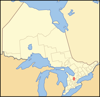
North Bay is a city in Northeastern Ontario, Canada. It is the seat of Nipissing District, and takes its name from its position on the shore of Lake Nipissing. North Bay developed as a railroad centre, and its airport was an important military location during the Cold War. The city is located 350 kilometres (220 mi) from both Ottawa and Toronto.

<span class="mw-page-title-main">Caledon, Ontario</span> Town in Ontario, Canada

Caledon is a town in the Regional Municipality of Peel in the Greater Toronto Area of Ontario, Canada. The name comes from a shortened form of Caledonia, the Roman name for what is now Scotland. Caledon is primarily rural with a number of hamlets and small villages, but also contains the larger community of Bolton in its southeastern quadrant, adjacent to York Region. Some spillover urbanization also occurs in the south bordering the City of Brampton.

<span class="mw-page-title-main">Markham, Ontario</span> City in Ontario, Canada

Markham is a city in York Region, Ontario, Canada. It is approximately 30 km (19 mi) northeast of Downtown Toronto. In the 2021 Census, Markham had a population of 338,503, which ranked it the largest in York Region, fourth largest in the Greater Toronto Area (GTA), and 16th largest in Canada.

<span class="mw-page-title-main">Oakville, Ontario</span> Town in Ontario, Canada

Oakville is a town in Halton Region, Ontario, Canada. It is located on Lake Ontario between Toronto and Hamilton. At its 2021 census population of 213,759, it is Ontario's largest town. Oakville is part of the Greater Toronto Area, one of the most densely populated areas of Canada.

<span class="mw-page-title-main">Golden Horseshoe</span> Secondary region in Ontario, Canada

The Golden Horseshoe is a secondary region of Southern Ontario, Canada, which lies at the western end of Lake Ontario, with outer boundaries stretching south to Lake Erie and north to Lake Scugog, Lake Simcoe and Georgian Bay of Lake Huron. The region is the most densely populated and industrialized in Canada. Based on the 2021 census, with a population of 7,759,635 people in its core and 9,765,188 in its greater area, the Golden Horseshoe accounts for over 20 percent of the population of Canada and more than 54 percent of Ontario's population. It is part of the Quebec City–Windsor Corridor, itself part of the Great Lakes megalopolis.

<span class="mw-page-title-main">Scarborough, Ontario</span> District of Toronto, Ontario, Canada

Scarborough is a district of Toronto, Ontario, Canada. It is situated atop the Scarborough Bluffs in the eastern part of the city. Its borders are Victoria Park Avenue to the west, Steeles Avenue and the city of Markham to the north, Rouge River and the city of Pickering to the east, and Lake Ontario to the south. Scarborough was named after the English town of Scarborough, North Yorkshire, inspired by its cliffs.

<span class="mw-page-title-main">County of Brant</span> City in Ontario, Canada

The County of Brant is a single-tier municipality in the Canadian province of Ontario. Although it retains the word "county" in its name, the municipality is a single-tier municipal government and has no upper tier. The County of Brant has service offices in Burford, Paris, Oakland, Onondaga and St. George. The largest population centre is Paris.

<span class="mw-page-title-main">Kawartha Lakes</span> City in Ontario, Canada

The City of Kawartha Lakes is a unitary municipality in Central Ontario, Canada. It is a municipality legally structured as a single-tier city; however, Kawartha Lakes is the size of a typical Ontario county and is mostly rural. It is the second largest single-tier municipality in Ontario by land area.

<span class="mw-page-title-main">Simcoe County</span> County in Ontario, Canada

Simcoe County is located in the central portion of Southern Ontario, Canada. The county is just north of the Greater Toronto Area, stretching from the shores of Lake Simcoe in the east to Georgian Bay in the west. Simcoe County forms part of the Greater Golden Horseshoe area, a densely populated and industrialized region, centred on the Greater Toronto Area.

<span class="mw-page-title-main">Restoule</span> Designated place with Local Services Board in Ontario, Canada

Restoule is a community and designated place in geographic Patterson Township in the Centre Unorganized Part of Parry Sound District in Central Ontario, Canada. It is situated on the Restoule River between Commanda Lake, and Restoule Lake and is part of the Almaguin Highlands region.

<span class="mw-page-title-main">Dufferin County</span> County in Ontario, Canada

Dufferin County is a county and census division located in Central Ontario, Canada. The county seat is Orangeville, and the current Warden is Wade Mills. The current chief administrative officer is Sonya Pritchard. Dufferin covers an area of 1,486.31 square kilometres (573.87 sq mi), and its population was 61,735 at the time of the 2016 Census.

<span class="mw-page-title-main">Calgary Metropolitan Region</span> Metropolitan area in Alberta, Canada

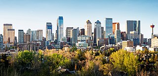
The Calgary Metropolitan Region (CMR), also commonly referred to as the Calgary Region, is a conglomeration of municipalities centred on Calgary, the largest city in Alberta.

<span class="mw-page-title-main">Nipissing—Timiskaming</span> Federal electoral district in Ontario, Canada

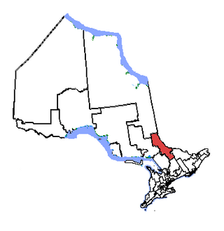
Nipissing—Timiskaming is a federal electoral district in Ontario, Canada, that has been represented in the House of Commons of Canada since 2004. The riding was formed by the amalgamation of the former Nipissing riding with the southeastern portion of the former Timiskaming—Cochrane riding. The 2011 electoral results in this riding were challenged in court on the grounds that there were "irregularities, fraud or corrupt or illegal practices that affected the result of the election".

<span class="mw-page-title-main">Parry Sound—Muskoka (federal electoral district)</span> Federal electoral district in Ontario, Canada

Parry Sound—Muskoka is a federal electoral district in Ontario, Canada, that has been represented in the House of Commons of Canada since 1949.

<span class="mw-page-title-main">Callander, Ontario</span> Canadian township established 1891

The Municipality of Callander is a township in central Ontario, Canada, located at the southeast end of Lake Nipissing in the Almaguin Highlands region of the District of Parry Sound. The municipality is located on Callander Bay, just south of North Bay.

<span class="mw-page-title-main">Nipissing, Ontario</span> Township in Ontario, Canada

Nipissing is an incorporated (political) township in Parry Sound District in Central Ontario, Canada. It is on Lake Nipissing and is part of the Almaguin Highlands region. Nipissing was surveyed between 1874 and 1881, and was incorporated in 1888. Among the first settlers in the area were the Chapman and Beatty families. Nipissing Township annexed Gurd Township in 1970. The township also contains a community named Nipissing, which is located on the South River near Chapman's Landing, on the South Bay of Lake Nipissing. The township administrative offices are located in Nipissing.

<span class="mw-page-title-main">Parry Sound—Muskoka (provincial electoral district)</span> Provincial electoral district in Ontario, Canada

Parry Sound—Muskoka is a provincial electoral district in the Canadian province of Ontario.

<span class="mw-page-title-main">Alnwick/Haldimand</span> Township in Ontario, Canada

The Township of Alnwick/Haldimand is a township in central Ontario, Canada, in Northumberland County, situated between Lake Ontario and Rice Lake. It was formed in 2001 by the merger of Alnwick Township in the north and Haldimand Township in the south. Alderville First Nation is an autonomously governed First Nation contained within the township boundaries, in two non-contiguous sections along County Roads 45 and 18.

<span class="mw-page-title-main">Trout Creek, Ontario</span> Place in Ontario, Canada

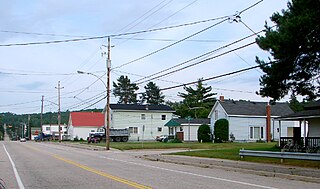
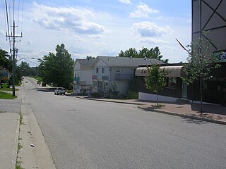
Trout Creek is a community and unincorporated area in the municipality of Powassan, Parry Sound District in Northern Ontario, Canada. It is in geographic South Himsworth Township; is located on Ontario Highway 11, 12 kilometres (7 mi) south of the town centre of Powassan; and is part of the Almaguin Highlands.

The South is a river in the Almaguin Highlands region of Parry Sound District, Ontario, beginning in the Western Uplands of Algonquin Provincial Park and emptying into Lake Nipissing. The river takes its name from an arm of Lake Nipissing into which it flows, South Bay.

References

  1. "Council". Town of Powassan. Retrieved March 8, 2019.
  2. 1 2 "2021 Census Profile: Powassan, Municipality". Statistics Canada. Retrieved February 9, 2022.
  3. "The Powassan Story". Town of Powassan. Retrieved March 8, 2019.
  4. Kemenesi G, Bányai K (January 2019). "Tick-Borne Flaviviruses, with a Focus on Powassan Virus". Clinical Microbiology Reviews. 32 (1): e00106–17, /cmr/32/1/e00106–17.atom. doi:10.1128/CMR.00106-17. PMC   6302355 . PMID   30541872.
  5. Patel KM, Johnson J, Zacharioudakis IM, Boxerman JL, Flanigan TP, Reece RM (2018). "First confirmed case of Powassan neuroinvasive disease in Rhode Island". IDCases. 12: 84–87. doi:10.1016/j.idcr.2018.03.016. PMC   6010959 . PMID   29942757.
  6. "Powassan, Ontario". Canadian Climate Normals 1981–2010. Environment Canada. 31 October 2011. Retrieved February 16, 2015.
  7. "2021 Community Profiles". 2021 Canadian Census . Statistics Canada. February 4, 2022.
  8. "2016 Community Profiles". 2016 Canadian Census . Statistics Canada. August 12, 2021.
  9. "2011 Community Profiles". 2011 Canadian Census . Statistics Canada. March 21, 2019.
  10. "2006 Community Profiles". 2006 Canadian Census . Statistics Canada. August 20, 2019.
  11. "2001 Community Profiles". 2001 Canadian Census . Statistics Canada. July 18, 2021.
  12. "1991 Census Highlights" (PDF). The Daily. Statistics Canada. April 28, 1992. p. 9. Archived (PDF) from the original on March 24, 2014. Retrieved March 12, 2022.
  13. "Population and dwelling counts: Canada, provinces and territories, census divisions and census subdivisions (municipalities), Ontario". Statistics Canada. February 9, 2022. Retrieved March 31, 2022.
  14. https://publications.gc.ca/collections/collection_2017/statcan/CS92-703-1971.pdf
  15. https://publications.gc.ca/collections/collection_2017/statcan/CS92-533-1961.pdf
  16. https://publications.gc.ca/collections/collection_2017/statcan/CS98-1951-1.pdf
  17. https://publications.gc.ca/collections/collection_2017/statcan/CS98-1931-1-eng.pdf
  18. https://publications.gc.ca/collections/collection_2017/statcan/CS98-1921-1-1924.pdf