
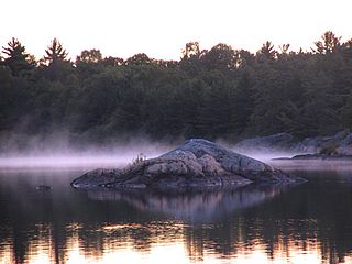
Georgian Bay is a large bay of Lake Huron, in the Laurentia bioregion. It is located entirely within the borders of Ontario, Canada. The main body of the bay lies east of the Bruce Peninsula and Manitoulin Island. To its northwest is the North Channel.

Parry Sound is a town in Ontario, Canada, located on the eastern shore of the sound after which it is named. Parry Sound is located 160 km (99 mi) south of Sudbury and 225 km (140 mi) north of Toronto. It is a single tier government located in the territorial District of Parry Sound which has no second tier County, Regional or District level of government. Parry Sound is a popular cottage country region for Southern Ontario residents. It also has the world's deepest natural freshwater port.

Simcoe County is located in the central portion of Southern Ontario, Canada. The county is just north of the Greater Toronto Area, stretching from the shores of Lake Simcoe in the east to Georgian Bay in the west. Simcoe County forms part of the Greater Golden Horseshoe area, a densely populated and industrialized region, centred on the Greater Toronto Area.
Parry Sound District is a census division of the Canadian province of Ontario. Its boundaries are District of Muskoka to the south, the Sudbury District to the north-northwest, the French River and Lake Nipissing in the north, Nipissing District and North Bay in the north and east and parts of Algonquin Park in the northeast.
The Archipelago is a township in central Ontario, Canada, along the Georgian Bay in the District of Parry Sound.
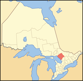
Unorganized Centre Parry Sound District is an unorganized area in central Ontario, Canada, between Georgian Bay and Lake Nipissing in the District of Parry Sound. It is made up of geographic townships which have no governing bodies and which are not incorporated as municipalities. The territory consists of two non-contiguous areas, with the main part located directly south of the French River and Lake Nipissing, and east of Georgian Bay. Shawanaga Township is a small exclave south of it along Highway 69.
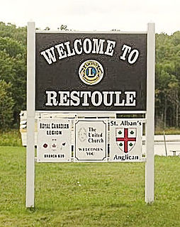
Restoule is a community and designated place in geographic Patterson Township in the Centre Unorganized Part of Parry Sound District in Central Ontario, Canada. It is situated on the Restoule River between Commanda Lake, and Restoule Lake and is part of the Almaguin Highlands region.

The Ironworkers Memorial Second Narrows Crossing, also called the Ironworkers Memorial Bridge and Second Narrows Bridge, is the second bridge constructed at the Second (east) Narrows of Burrard Inlet in Vancouver, British Columbia, Canada. Originally named the Second Narrows Bridge, it connects Vancouver to the North Shore of Burrard Inlet, which includes the District of North Vancouver, the City of North Vancouver, and West Vancouver. It was constructed adjacent to the older Second Narrows Bridge, which is now exclusively a rail bridge. Its construction, from 1956 to 1960, was marred by a multi-death collapse on June 17, 1958. The First Narrows Bridge, better known as Lions Gate Bridge, crosses Burrard Inlet about 8 kilometres (5.0 mi) west of the Second Narrows.

The Magnetawan River is a long river in Parry Sound District, Ontario, Canada. The river flows 175 km from its source of Magnetawan Lake inside Algonquin Provincial Park to empty into Georgian Bay at the community of Britt on Byng Inlet.
King's Highway 69, commonly referred to as Highway 69, is a provincially maintained north–south highway in the central portion of the Canadian province of Ontario. In conjunction with Highway 400, it links Toronto with the city of Greater Sudbury at Highway 17, via Parry Sound. It is part of the Trans-Canada Highway and the National Highway System. From its southern terminus of Highway 559 at Carling, Highway 69 begins as Highway 400 narrows from a four-laned freeway to a two lane highway. It travels northerly for approximately 68 kilometres (42 mi) to south of the French River before widening back to a divided four lane freeway for approximately 64 kilometres (40 mi) into Sudbury. The final 6 kilometres (3.7 mi) of the route, connecting to Highway 17, is a five lane arterial road that will be converted to freeway as the final phase of the four-laning.
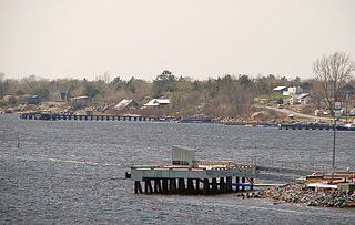
Byng Inlet is a ghost town and community in Unorganized Centre Parry Sound District, Ontario, Canada. For a period in the nineteenth century it was home to one of the largest sawmill operations in Canada. The name of the town came from that of the English Admiral John Byng. It is also the name of the body of water, on which the village is situated, on the south shore of the Byng Inlet a widening of the Magnetawan River, near its mouth on Georgian Bay.

Pointe au Baril is a community in the Canadian province of Ontario, located on the east coast of Georgian Bay.
Secondary Highway 526, commonly referred to as Highway 526, is a provincially maintained secondary highway in the Canadian province of Ontario. It is a short and lightly travelled route that connects Highway 69 with the community of Britt.
Byng Inlet is a body of water on the eastern shore of Georgian Bay, between Parry Sound and the mouth of the French River. It is a widening of the Magnetawan River, near its mouth. The name of the river "Magnetawan", meaning "long open channel" in the Ojibwe language, refers to this section of the river.
Secondary Highway 529, commonly referred to as Highway 529, is a provincially maintained secondary highway in the Canadian province of Ontario. Located within Parry Sound District, the highway follows a 25.7-kilometre (16.0 mi) route, from its southern terminus at Highway 69 near Pointe au Baril to its northern terminus at the Highway 69 crossing of the Magnetawan River near Byng Inlet. Two spur routes, Highway 529A and Highway 645, branch off the highway to serve the communities of Bayfield Inlet and Byng Inlet, respectively. The route was established along the present alignment of Highway 529A in 1956. It was relocated in 1961 along the former routing of Highway 69 when a bypass opened through the area, with the former alignment being renumbered as Highway 529A.

The Metamora was a wooden tug commissioned in 1864 and used predominantly for ferrying passengers and goods in the Georgian Bay area of Ontario. It ran onto a shallow shoal near Turning Island in Georgian Bay on July 30, 1907, caught fire and sank in six feet of water.
Wallbridge is an unorganized geographic township in Parry Sound District, Ontario, Canada. Part of the census subdivision of Unorganized Centre Parry Sound District, the township includes the communities of Britt, Byng Inlet and Harris Lake and the rail sidings of Drocourt and North Magnetawan. Although not an incorporated municipality, Britt and Byng Inlet are jointly served by a local services board.
Henvey is an unorganized geographic township in the Canadian province of Ontario, located within the Parry Sound District. Part of the census subdivision of Unorganized Centre Parry Sound District, the township includes the communities of Britt Station and Still River. It formerly had larger boundaries, also including the ghost town of Key Harbour, although the more northerly section was transferred to the municipality of Killarney in the 1990s. Britt Station is part of the local services board of Britt and Byng Inlet.

Northern Belle was a steamship that provided service in Ontario, Canada, from 1875 to her accidental destruction by fire in 1898.

