
Northumberland County is located in northeastern New Brunswick, Canada.

Victoria County is located in northwestern New Brunswick, Canada. Farming, especially of potatoes, is the major industry in the county. The area was named for Queen Victoria.

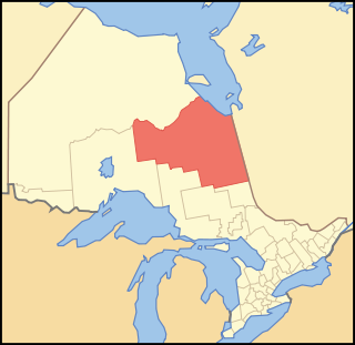
Northumberland County is an upper-tier municipality situated on the north shore of Lake Ontario, east of Toronto in Central Ontario. The Northumberland County headquarters are located in Cobourg.
Cochrane District is a district and census division in Northeastern Ontario in the Canadian province of Ontario. It was created in 1921 from parts of Timiskaming and Thunder Bay districts.
Parry Sound District is a census division of the Canadian province of Ontario. Its boundaries are District of Muskoka to the south, the Sudbury District to the north-northwest, the French River and Lake Nipissing in the north, Nipissing District and North Bay in the north and east and parts of Algonquin Park in the northeast.
Unorganized Centre Parry Sound District is an unorganized area in central Ontario, Canada, between Georgian Bay and Lake Nipissing in the District of Parry Sound. It is made up of geographic townships which have no governing bodies and which are not incorporated as municipalities. The territory consists of two non-contiguous areas, with the main part located directly south of the French River and Lake Nipissing, and east of Georgian Bay. Shawanaga Township is a small exclave south of it along Highway 69.
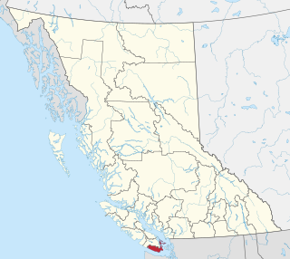
The Capital Regional District (CRD) is a local government administrative district encompassing the southern tip of Vancouver Island and the southern Gulf Islands in the Canadian province of British Columbia. The CRD is one of several regional districts in British Columbia and had an official population of 415,451 as of the Canada 2021 Census.

Montebello is a municipality located in the Papineau Regional County Municipality of Western Quebec, Canada. At the 2001 census, there were 1,039 permanent residents. The village has a total area of 7.95 square kilometres (3.07 sq mi), and is located at the eastern edge of Quebec's Outaouais region. It is located on the border with Ontario.
Birch Hills is a town located in Saskatchewan, Canada. It is located southeast of Prince Albert and the reserve of Muskoday First Nation. Directly to the west is the village of St. Louis, and to the east is Kinistino. It is surrounded by, but not part of, Birch Hills Rural Municipality No. 460.
The Aamjiwnaang First Nation is an Anishinaabe (Ojibwe) First Nations Band located on reserve land by the St. Clair River in Ontario, Canada, three miles south of the southern tip of Lake Huron. The reserve is located across from the United States border from Port Huron, Michigan, and is a result of treaties that were negotiated with the Crown in the 1820s. There are approximately 2,000 band members with about 850 living on the reserve. Their heritage language is Ojibwe.

Plaisance is a municipality in Papineau Regional County Municipality in western Quebec, Canada. The village is situated on the Ottawa River near the mouth of the Petite-Nation River, 70 km from Gatineau and 160 km from Montreal on Route 148.
Lac Brochet 197A is a Dene Indian reserve of the Northlands Denesuline First Nation, located in the boreal forest of northern Manitoba, Canada. It is situated on the north shore of Lac Brochet, located 240 km (150 mi) northwest of the city of Thompson.

Timiskaming is a First Nations reserve in the Abitibi-Témiscamingue region of Quebec, Canada, just north of the head of Lake Timiskaming. It belongs to the Timiskaming First Nation, an Algonquin band. It is geographically within the Témiscamingue Regional County Municipality but administratively not part of it.
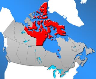
Nunavut is a territory of Canada. It has a land area of 1,877,787.62 km2 (725,017.85 sq mi). It has a population of 36,858 in the 2021 Census. In the 2016 census the population was 35,944, up 12.7% from the 2011 census figure of 31,906. In 2016, 30,135 people identified themselves as Inuit, 190 as North American Indian (0.5%), 165 Métis (0.5%) and 5,025 as non-aboriginal (14.0%).
Saugeen 29 is a First Nations reserve in Bruce County, Ontario. It is the main reserve of the Saugeen First Nation.

Kitigan Zibi is a First Nations reserve of the Kitigan Zibi Anishinabeg First Nation, an Algonquin band. It is situated near the confluence of the Désert and Gatineau Rivers, and borders south-west on the Town of Maniwaki in the Outaouais region of Quebec, Canada. Having a total area of 210.09 km2 (81.12 sq mi), it is the largest Algonquin Nation in Canada in both area and population.
Hatchet Lake Denesuline Nation is a Denesuline First Nation in northern Saskatchewan. The main settlement, Wollaston Lake, is an unincorporated community on Wollaston Lake in the boreal forest of north-eastern Saskatchewan, Canada.

Manawan, officially named communauté Atikamekw de Manawan, is a First Nations reserve on the south-western shores of Lake Métabeskéga in the Lanaudière region of Quebec, Canada. It belongs to the Atikamekw of Manawan band of the Atikamekw Nation.
The Montreal Lake Cree Nation is a Woodland Cree First Nation in northern Saskatchewan. The administrative centre of the Montreal Lake Cree Nation is located in the community of Montreal Lake.
French River 13 is an Ojibway First Nations reserve in Parry Sound District, Ontario. It is one of the reserves of the Henvey Inlet First Nation.


