
In geology, a supercontinent is the assembly of most or all of Earth's continental blocks or cratons to form a single large landmass. However, some geologists use a different definition, "a grouping of formerly dispersed continents", which leaves room for interpretation and is easier to apply to Precambrian times. To separate supercontinents from other groupings, a limit has been proposed in which a continent must include at least about 75% of the continental crust then in existence in order to qualify as a supercontinent.

Laurasia was the more northern of two large landmasses that formed part of the Pangaea supercontinent from around 335 to 175 million years ago (Mya), the other being Gondwana. It separated from Gondwana 215 to 175 Mya during the breakup of Pangaea, drifting farther north after the split and finally broke apart with the opening of the North Atlantic Ocean c. 56 Mya. The name is a portmanteau of Laurentia and Asia.

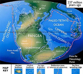
The Tethys OceanTEETH-iss, TETH-, also called the Tethys Sea or the Neo-Tethys, was a prehistoric ocean during much of the Mesozoic Era and early Cenozoic Era, located between the ancient continents of Gondwana and Laurasia, before the opening of the Indian and Atlantic oceans during the Cretaceous Period.

Atlantica is an ancient continent that formed during the Proterozoic about 2,000 million years ago from various 2 Ga cratons located in what are now West Africa and eastern South America. The name, introduced by Rogers 1996, was chosen because the parts of the ancient continent are now located on opposite sides of the South Atlantic Ocean.

Avalonia was a microcontinent in the Paleozoic era. Crustal fragments of this former microcontinent underlie south-west Great Britain, southern Ireland, and the eastern coast of North America. It is the source of many of the older rocks of Western Europe, Atlantic Canada, and parts of the coastal United States. Avalonia is named for the Avalon Peninsula in Newfoundland.
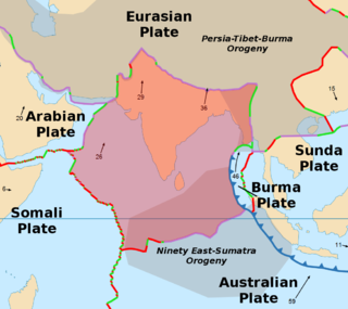
The Indian Plate is a minor tectonic plate straddling the equator in the Eastern Hemisphere. Originally a part of the ancient continent of Gondwana, the Indian Plate broke away from the other fragments of Gondwana 100 million years ago, began moving north and carried Insular India with it. It was once fused with the adjacent Australian Plate to form a single Indo-Australian Plate, and recent studies suggest that India and Australia have been separate plates for at least 3 million years and likely longer. The Indian Plate includes most of modern South Asia and a portion of the basin under the Indian Ocean, including parts of South China and western Indonesia, and extending up to but not including Ladakh, Kohistan and Balochistan.

The Variscan or Hercynianorogeny was a geologic mountain-building event caused by Late Paleozoic continental collision between Euramerica (Laurussia) and Gondwana to form the supercontinent of Pangaea.
The Pan-African orogeny was a series of major Neoproterozoic orogenic events which related to the formation of the supercontinents Gondwana and Pannotia about 600 million years ago. This orogeny is also known as the Pan-Gondwanan or Saldanian Orogeny. The Pan-African orogeny and the Grenville orogeny are the largest known systems of orogenies on Earth. The sum of the continental crust formed in the Pan-African orogeny and the Grenville orogeny makes the Neoproterozoic the period of Earth's history that has produced most continental crust.
The Proto-Tethys or Theic Ocean was an ancient ocean that existed from the latest Ediacaran to the Carboniferous.
Cimmeria was an ancient continent, or, rather, a string of microcontinents or terranes, that rifted from Gondwana in the Southern Hemisphere and was accreted to Eurasia in the Northern Hemisphere. It consisted of parts of present-day Turkey, Iran, Afghanistan, Pakistan, Tibet, China, Myanmar, Thailand, and Malaysia. Cimmeria rifted from the Gondwanan shores of the Paleo-Tethys Ocean during the Early Permian and as the Neo-Tethys Ocean opened behind it, during the Permian, the Paleo-Tethys closed in front of it. Because the different chunks of Cimmeria drifted northward at different rates, a Meso-Tethys Ocean formed between the different fragments during the Cisuralian. Cimmeria rifted off Gondwana from east to west, from Australia to the eastern Mediterranean. It stretched across several latitudes and spanned a wide range of climatic zones.

The geological history of the Earth follows the major geological events in Earth's past based on the geological time scale, a system of chronological measurement based on the study of the planet's rock layers (stratigraphy). Earth formed about 4.54 billion years ago by accretion from the solar nebula, a disk-shaped mass of dust and gas left over from the formation of the Sun, which also created the rest of the Solar System.

Gondwana was a large landmass, sometimes referred to as a supercontinent. It was formed by the accretion of several cratons, beginning c. 800 to 650Ma with the East African Orogeny, the collision of India and Madagascar with East Africa, and culminating in c. 600 to 530 Ma with the overlapping Brasiliano and Kuunga orogenies, the collision of South America with Africa, and the addition of Australia and Antarctica, respectively. Eventually, Gondwana became the largest piece of continental crust of the Palaeozoic Era, covering an area of some 100,000,000 km2 (39,000,000 sq mi), about one-fifth of the Earth's surface. It fused with Euramerica during the Carboniferous to form Pangea. It began to separate from northern Pangea (Laurasia) during the Triassic, and started to fragment during the Early Jurassic. The final stages of break-up, involving the separation of Antarctica from South America and Australia, occurred during the Paleogene (from around 66 to 23 million years ago. Gondwana was not considered a supercontinent by the earliest definition, since the landmasses of Baltica, Laurentia, and Siberia were separated from it. To differentiate it from the Indian region of the same name, it is also commonly called Gondwanaland.
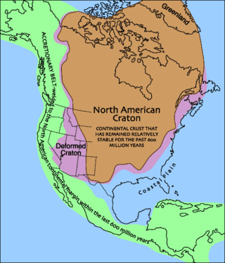
Laurentia or the North American Craton is a large continental craton that forms the ancient geological core of North America. Many times in its past, Laurentia has been a separate continent, as it is now in the form of North America, although originally it also included the cratonic areas of Greenland and also the northwestern part of Scotland, known as the Hebridean Terrane. During other times in its past, Laurentia has been part of larger continents and supercontinents and itself consists of many smaller terranes assembled on a network of Early Proterozoic orogenic belts. Small microcontinents and oceanic islands collided with and sutured onto the ever-growing Laurentia, and together formed the stable Precambrian craton seen today.

Pangaea or Pangea was a supercontinent that existed during the late Paleozoic and early Mesozoic eras. It assembled from the earlier continental units of Gondwana, Euramerica and Siberia during the Carboniferous approximately 335 million years ago, and began to break apart about 200 million years ago, at the end of the Triassic and beginning of the Jurassic. In contrast to the present Earth and its distribution of continental mass, Pangaea was centred on the equator and surrounded by the superocean Panthalassa and the Paleo-Tethys and subsequent Tethys Oceans. Pangaea is the most recent supercontinent to have existed and the first to be reconstructed by geologists.
This is a list of articles related to plate tectonics and tectonic plates.

The Iberian Plate is a microplate typically grouped with the Eurasian Plate that includes the microcontinent Iberia, Corsica, Sardinia, the Balearic Islands, the Briançonnais zone of the Penninic nappes of the Alps, and the portion of Morocco north of the High Atlas Mountains. The Iberian plate is a part of the Eurasian plate.
A paleocontinent or palaeocontinent is a distinct area of continental crust that existed as a major landmass in the geological past. There have been many different landmasses throughout Earth's time. They range in sizes, some are just a collection of small microcontinents while others are large conglomerates of crust. As time progresses and sea levels rise and fall more crust can be exposed making way for larger landmasses. The continents of the past shaped the evolution of organisms on Earth and contributed to the climate of the globe as well. As landmasses break apart, species are separated and those that were once the same now have evolved to their new climate. The constant movement of these landmasses greatly determines the distribution of organisms on Earth's surface. This is evident with how similar fossils are found on completely separate continents. Also, as continents move, mountain building events (orogenies) occur, causing a shift in the global climate as new rock is exposed and then there is more exposed rock at higher elevations. This causes glacial ice expansion and an overall cooler global climate. The movement of the continents greatly affects the overall dispersal of organisms throughout the world and the trend in climate throughout Earth's history. Examples include Laurentia, Baltica and Avalonia, which collided together during the Caledonian orogeny to form the Old Red Sandstone paleocontinent of Laurussia. Another example includes a collision that occurred during the late Pennsylvanian and early Permian time when there was a collision between the two continents of Tarimsky and Kirghiz-Kazakh. This collision was caused because of their askew convergence when the paleoceanic basin closed.

The Qinling orogenic belt is a tectonic feature that evolved throughout the Proterozoic and Phanerozoic eons due to a variety of tectonic activities. It is a part of the Central China Orogenic Belt, aligned in an east–west orientation across Central China, and spans portions of Shaanxi, Henan and Gansu provinces along the Qinling Mountains which are one of the greatest mountain ranges in China. The first materials involved in the Qinling orogenic belt formed around 2.5 billion years ago, whereas the main morphology of the belt now largely reflects the Triassic collision between the North China Plate and the South China Plate and Cenozoic extension across China. During these 2.5 billion years, various types of rocks have been formed here due to different tectonic processes and chemical reactions between rocks. Therefore, geologists are able to reconstruct the evolution of mountain belt based on evidence preserved in these rocks.
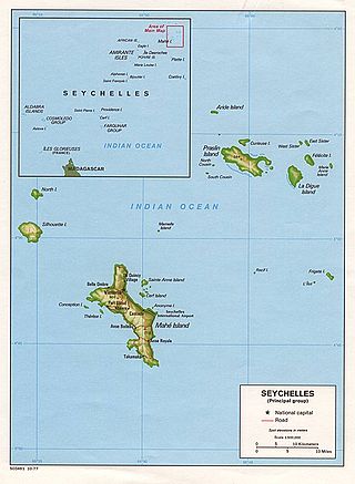
The geology of Seychelles is an example of a felsic granite microcontinent that broke off from the supercontinent Gondwana within the past 145 million years and become isolated in the Indian Ocean. The islands are primarily granite rock, with some sequences of sedimentary rocks formed during rift basin periods or times when the islands were submerged in shallow water.

Argoland is the tentative name of a hypothetical paleocontinent which was suggested to rift off from northwestern Australia some 155 Ma ago. The evidence for this was drawn from the existence of the Argo Abyssal Plain northwestwards off Australia. An October 2023 article by Advokaat and van Hinsbergen attempted to reconstruct Argoland, where it is suggested that it was an archipelago rather than a solid continent and currently its Gondwana-derived fragments are southwest Borneo, Greater Paternoster, East Java, South Sulawesi, West Burma block, and Mount Victoria Land block.
