Related Research Articles

Saint Paul is the capital of the U.S. state of Minnesota and the county seat of Ramsey County. Situated on high bluffs overlooking a bend in the Mississippi River, Saint Paul is a regional business hub and the center of Minnesota's government. The Minnesota State Capitol and the state government offices all sit on a hill close to the city's downtown district. One of the oldest cities in Minnesota, Saint Paul has several historic neighborhoods and landmarks, such as the Summit Avenue Neighborhood, the James J. Hill House, and the Cathedral of Saint Paul. Like the adjacent city of Minneapolis, Saint Paul is known for its cold, snowy winters and humid summers.

Winona is a city in and the county seat of Winona County, Minnesota, United States. Located in bluff country on the Mississippi River, its most noticeable physical landmark is Sugar Loaf. The population was 25,948 at the 2020 census.

The Richmond District is a neighborhood in the northwest corner of San Francisco, California, developed initially in the late 19th century. It is sometimes confused with the city of Richmond, which is 20 miles (32 km) northeast of San Francisco; accordingly, the neighborhood usually is referred to as "the Richmond."

Hmong Americans are Americans of Hmong ancestry. Many Hmong Americans immigrated to the United States as refugees in the late 1970s, with a second wave in the 1980s and 1990s. Over half of the Hmong population from Laos left the country, or attempted to leave, in 1975, at the culmination of the Laotian Civil War.

The East Side is a district of Milwaukee, Wisconsin consisting of several neighborhoods encompassing an area just north of Downtown Milwaukee to the village of Shorewood, bordered by the Milwaukee River to the west and Lake Michigan to the east. The area encompasses residences, museums, bars, shops, theaters, live music clubs and the University of Wisconsin–Milwaukee campus.

Longfellow, also referred to as Greater Longfellow is a defined community in Minneapolis, Minnesota which includes five smaller neighborhoods inside of it: Seward, Cooper, Hiawatha, Howe and Longfellow. The community is a mix of agri-industrial properties along the old Northern Pacific Railway, expansive parkland surrounding the famous Minnehaha Falls, and smaller residential areas.
Northeast is a defined community in the U.S. city of Minneapolis that is composed of 13 smaller neighborhoods whose street addresses end in "NE". Unofficially it also includes the neighborhoods of the University community which have "NE" addresses, and the entirety of the Old Saint Anthony business district, which sits on the dividing line of "NE" and "SE" addresses. In the wider community, this business district, which is the oldest settlement in the city, is often identified as the heart of Northeast, in part because it lies across the Mississippi River from Downtown Minneapolis. Northeast is sometimes referred to as "Nordeast", reflecting the history of northern and eastern European immigrants and their language influence.

Como is a neighborhood within the Southeast quadrant of Minneapolis. The neighborhood is also sometimes referred to as Southeast Como to help differentiate it from the Como Park neighborhood in neighboring Saint Paul. Its boundaries are East Hennepin Avenue to the north, 33rd Avenue Southeast to the east, the Southeast Industrial Area to the south, and Interstate 35W to the west. Como is also part of the University District in Minneapolis, with its location near the main Minneapolis campus of the University of Minnesota.

The demographics of Minnesota are tracked by the United States Census Bureau, with additional data gathered by the Minnesota State Demographic Center. According to the most recent estimates, Minnesota's population as of 2020 was approximately 5.7 million, making it the 22nd most populous state in the United States. The total fertility rate in Minnesota was roughly 1.87 in 2019, slightly below the replacement rate of 2.1.

Saint Anthony Park is a neighborhood in northwest Saint Paul, Minnesota. It is adjacent to the University of Minnesota's St. Paul Campus, bordering Prospect Park, Minneapolis on the west, the Minnesota State Fairgrounds on the east, and the suburbs of Falcon Heights and Lauderdale to the north.
The East Side Review was an American, English language newspaper headquartered in St. Paul, Minnesota, until publication ceased in September 2019. While it was published, it was the only neighborhood-focused, general-interest weekly newspaper in either Minneapolis or St. Paul.

Minneapolis Public Schools (MPS) or Special School District Number 1 is a public school district serving students in pre-kindergarten through twelfth grade from Minneapolis, Minnesota. Minneapolis Public Schools enrolls 36,370 students in public primary and secondary schools. The district administers about one hundred public schools including forty-five elementary schools, seven middle schools, seven high schools, eight special education schools, eight alternative schools, nineteen contract alternative schools, and five charter schools. With authority granted by the state legislature, the school board makes policy, selects the superintendent, and oversees the district's budget, curriculum, personnel, and facilities. Students speak ninety different languages at home and most school communications are printed in English, Hmong, Spanish, and Somali.

Saint Paul Public Schools 625 (SPPS) is a school district that operates in Saint Paul, Minnesota.

Since its founding in 1625 by Dutch traders as New Amsterdam, New York City has been a major destination for immigrants of many nationalities who have formed ethnic enclaves, neighborhoods dominated by one ethnicity. Freed African American slaves also moved to New York City in the Great Migration and the later Second Great Migration and formed ethnic enclaves. These neighborhoods are set apart from the main city by differences such as food, goods for sale, or even language. Ethnic enclaves provide inhabitants security in work and social opportunities, but limit economic opportunities, do not encourage the development of English speaking, and keep immigrants in their own culture.

Saint Paul, Minnesota, consists of 17 officially defined city districts or neighborhoods.

Saint Paul is the second largest city in the U.S. state of Minnesota, the county seat of Ramsey County, and the state capital of Minnesota. The origin and growth of the city were spurred by the proximity of Fort Snelling, the first major United States military installation in the area, as well as by the city's location on the northernmost navigable port of the Upper Mississippi River.

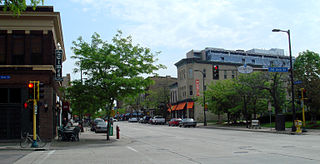
Frogtown is a neighborhood in Saint Paul in the U.S. state of Minnesota. Built around University Avenue, the Thomas-Dale neighborhood is colloquially known as Frogtown. Historically, Frogtown was a subsection of the current Thomas-Dale neighborhood. It is bordered by University Avenue on the south, the Burlington Northern Railroad tracks to the north, Lexington Parkway on the west and Rice Street on the east.

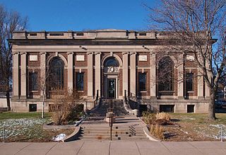
The East Side Freedom Library is an independent, non-profit library in the East Side neighborhood of Saint Paul, Minnesota, United States. Founded in 2013 by Beth Cleary and Peter Rachleff, it has occupied the Arlington Hills Carnegie library building since leasing it from the city of Saint Paul in 2014. The building is located in the Payne-Phalen neighborhood which is known for being a working-class neighborhood with a large immigrant population. The library's collections and programming focus on the labor history and diverse immigrant communities of the neighborhood.
Payne-Phalen is a neighborhood and city planning district in Saint Paul, Minnesota in the United States. It is Planning District 5. The area includes several smaller neighborhoods, namely Railroad Island, Phalen Park, Rivoli Bluff, Vento, Wheelock Park, and Williams Hill. It ranges from a blue-collar area to the south to a middle-class area north of Maryland Avenue, including upscale real estate around Lake Phalen. The neighborhood is part of the larger area known as the East Side of Saint Paul. Major streets in the neighborhood include E. 7th St, Phalen Boulevard, Arcade Street, which hosts U.S. Route 61 and Payne Avenue. Payne Avenue has been a major commercial corridor for the east side of Saint Paul since the 1930s.
References
- ↑ District 2 – Greater East Side District Plan Retrieved February 1st, 2024
- ↑ Greater East Side at Niche.com Retrieved February 1st, 2024
- ↑ About Prosperity Park Retrieved February 1st, 2024
- ↑ Eastside Freedom Library Retrieved February 2nd, 2024
- ↑ Hmong-Americans in Minnesota: Overview Retrieved February 1st, 2024
- ↑ East Side Employment xChange Retrieved February 1st, 2024
- ↑ Greater East Side neighborhood data Retrieved February 1st, 2024