
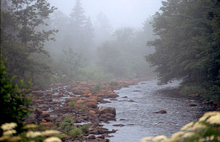
Green Bay in Nova Scotia
Green Bay is a community in the Canadian province of Nova Scotia, located in the Lunenburg Municipal District in Lunenburg County.
Green Bay is a community in the Canadian province of Nova Scotia, located in the Lunenburg Municipal District in Lunenburg County.
According to the Köppen climate classification, Green Bay is a humid continental climate typified by large seasonal temperature differences, with warm to hot (and often humid) summers, and cold (sometimes severely) winters.

Bridgewater is a town in Lunenburg County, Nova Scotia, Canada, at the navigable limit of the LaHave River. With a 2021 population of 8,790, Bridgewater is the largest town in the South Shore region.
Petite Rivière is a rural community on Route 331 in Lunenburg County on the South Shore of Nova Scotia in Canada. It was formerly known as Petite Rivière Bridge.
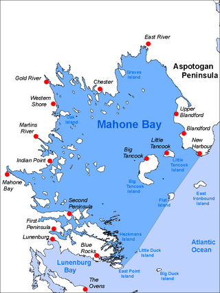
Mahone Bay is a bay on the Atlantic coast of Nova Scotia, Canada along the eastern end of Lunenburg County. The bay has many islands, and is a popular sailing area. Since 2003 the Mahone Islands Conservation Association has been working to protect the natural environment of the bay. The bay and its islands contain a variety of habitats including forests, rocky shores, beaches, wetlands, and mudflats. Wildlife in the area include black guillemots, eagles, osprey, leach's storm petrels, puffins, razorbills, and great blue herons.

Crescent Beach is a 2 km long, 40 to 65 m wide crescent-shaped beach, with white sand, not far from the community of LaHave and the town of Lunenburg. Other nearby communities are Green Bay and Petite Riviere. The beach is known for its sandy dunes and windsurfing.
The Aspotogan Peninsula is a peninsula in the eastern part of Lunenburg County, Nova Scotia, separating St. Margarets Bay in the east from Mahone Bay in the west. The peninsula was originally settled by second generation French immigrants on the east side and by second generation German immigrants on the west side. Traditionally fishing was a major industry for communities throughout the peninsula, however other primary industries such as farming and forestry were historically important as well. Shipping and shipbuilding were secondary and tertiary industries that also came into prominence during the 19th and early 20th centuries.
The Lighthouse Route is a scenic roadway in the Canadian province of Nova Scotia. It follows the province's South Shore for 585 km (364 mi) from Halifax to Yarmouth.
West Lawrencetown is a residential community within the Halifax Regional Municipality Nova Scotia on the Eastern Shore on Route 207 along the scenic route Marine Drive.

The Municipality of the District of Chester is a Nova Scotia district municipality occupying the northeastern half of Lunenburg County, Canada.
Mill Village is a Canadian rural community in the Region of Queens Municipality, Nova Scotia. It developed in relation to the lumber industry. Located inland from the Atlantic coast, Mill Village was the site of Canada's first satellite earth station constructed in the 1960s.
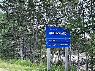
Queensland is a community of the Halifax Regional Municipality in the Canadian province of Nova Scotia.
Mill Cove is a community in the Canadian province of Nova Scotia, located in the Chester Municipal District on the Aspotogan Peninsula on the Lighthouse Route. The community was home to CFS Mill Cove from 1967 til the 1990s.
Blockhouse is a community in the Canadian province of Nova Scotia, located in the Lunenburg Municipal District in Lunenburg County. It was named after the blockhouses constructed by Captain Ephraim Cook to protect colonists following a raid in 1756. The final blockhouse in the community burned down in 1874.
Conquerall Mills is a community in the Canadian province of Nova Scotia, located in the Lunenburg Municipal District in Lunenburg County near Bridgewater and Conquerall Bank which are located on the shore of LaHave River. Conquerall Mills is dominated by Fancy Lake which is the source for the picturesque Petite Rivière. Fancy Lake is home to small mouth bass and the invasive species of chain pickerel. There are warnings against fishing the endangered Atlantic White fish which are rumoured to exist in the Fancy Lake/Petite Rivière system. The community is 125 kilometers southwest of Halifax.
Mader's Cove is a community in the Canadian province of Nova Scotia, located in the Lunenburg Municipal District in Lunenburg County. The current area is mostly along the Mader's Cove Road along the waters of Mahone Bay and includes Westhaver Beach. It is bounded on the west by the old railway, now part of the Bay to Bay Trail, that runs along the old number 3 Highway.
Cookville is a community in the Canadian province of Nova Scotia, located in the Lunenburg Municipal District in Lunenburg County.
Crescent Beach is a community in the Canadian province of Nova Scotia, located in the Lunenburg Municipal District in Lunenburg County. The community gets its name from the nearby beach of the same name. See Crescent Beach.
Lower Branch is a community in the Canadian province of Nova Scotia, located in the Lunenburg Municipal District.
Lake George is a community in the Canadian province of Nova Scotia, located in Kings County.

The Raid on Lunenburg occurred during the French and Indian War when Indigenous forces attacked a British settlement at Lunenburg, Nova Scotia on May 8, 1756. The indigenous forces raided two islands on the northern outskirts of the fortified Township of Lunenburg, Rous Island and Payzant Island. The raiding party killed five settlers and took five prisoners. This raid was the first of nine that the Indigenous and Acadian forces conducted against the Lunenburg peninsula over the next three-years of the war. The Indigenous forces took John Payzant and Lewis Payzant prisoner, both of whom left captivity narratives of their experiences.
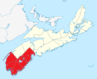
Southern Nova Scotia or the South Shore is a region of Nova Scotia, Canada. The area has no formal identity and is variously defined by geographic, county and other political boundaries. Statistics Canada, defines Southern Nova Scotia as an economic region, composed of Lunenburg County, Queens County, Shelburne County, Yarmouth County, and Digby County. According to Statistics Canada, the region had the highest decrease of population in Canada from 2009 to 2010, with a population decrease of 10.2 residents per thousand. The region also has the second-highest median age in Canada at 47.1 years old.
| | This Lunenburg County, Nova Scotia location article is a stub. You can help Wikipedia by expanding it. |