Green Line (Sacramento RT)

Last updated

Green Line
GreenLinesacrt.jpg
Light rail car wearing a promotional Green Line wrap
Overview
Owner Sacramento Regional Transit District
Locale Sacramento, California
Termini
Stations7
Service
Type Light rail
System Sacramento RT Light Rail
ServicesLine 519
Daily ridership440 (Q2 2018) [1]
History
OpenedJune 15, 2012;12 years ago (2012-06-15) [2]
Technical
Number of tracks2
CharacterAt-grade street running
Track gauge 4 ft 8+12 in (1,435 mm) standard gauge
Electrification Overhead line,  750 V DC
Route map
Green Line (Sacramento RT) Green Line highlighted in green
BSicon exCONTg jade.svg
proposed extension
to Sacramento Airport
BSicon KBHFxa jade.svg
7th and Richards/
Township 9
Greyhound no dog.svg BSicon BUS2.svg
BSicon CONTgq.svg
BSicon mKRZu jade+.svg
BSicon CONTfq.svg
BSicon LOGO Amtrak2.svg
BSicon bSHI2lr jade.svg
BSicon CONTgq saffron.svg
BSicon STRq saffron.svg
BSicon STR jade.svg
BSicon tSTR+r saffron.svg
BSicon STR+r saffron.svg
BSicon STR jade.svg
BSicon tSTR+r saffron.svg
BSicon STR+r saffron.svg
  Gold  
BSicon tSTR saffron.svg
BSicon lBHF jade.svg
BSicon NULf.svg
BSicon STR jade.svg
BSicon tSTR saffron.svg
BSicon lBHF jade.svg
BSicon NULg.svg
BSicon STR jade.svg
County Center (7th & I8th & H)
BSicon tSTR saffron.svg
BSicon STRf jade.svg
BSicon tSTR saffron.svg
BSicon lBHF jade.svg
BSicon NULg.svg
BSicon STR jade.svg
8th & K
BSicon STR jade.svg
BSicon tSTR saffron.svg
BSicon tSTR+l denim.svg
BSicon STR+l denim.svg
BSicon STRq denim.svg
BSicon STR jade.svg
BSicon tSTR saffron.svg
BSicon tSTR+l denim.svg
BSicon STR+l denim.svg
BSicon dCONTfq denim.svg
BSicon NULf.svg
BSicon eBHF black.svg
BSicon STRg black.svg
7th & K
(closed 2016)
BSicon NULf.svg
BSicon BHF black.svg
BSicon NULg.svg
BSicon BHF black.svg
7th & Capitol8th & Capitol
BSicon bSHI2+lr black.svg
BSicon BHF black.svg
8th & O
BSicon BUS2.svg
BSicon BHF black.svg
Archives Plaza
BSicon uYRDeq.svg
BSicon STR black.svg
BSicon uABZr+r.svg
R Street Yard
BSicon tKSTRa denim.svg
BSicon KBHFe black.svg
BSicon KSTRa saffron.svg
13th Street
BSicon USTr denim.svg
BSicon tCONTf denim.svg
BSicon CONTf saffron.svg
Blue
Gold
BSicon tSTRq saffron.svg
BSicon STRq jade.svg
Other service sharing track
BSicon STRq black.svg
Multiple services sharing track with Green Line

Wheelchair symbol.svg All stations are accessible

The Green Line is a light rail transit line in the Sacramento Regional Transit District (RT) light rail system. It opened on June 15, 2012, [2] and runs between 13th Street station and 7th and Richards/Township 9 station. The Green Line runs through north downtown to Township 9 in the River District, and is projected eventually to reach Sacramento International Airport. The line only operates on weekdays. [3]

Contents

History

In the 1990s, Sacramento RT started identifying corridors for new light rail extensions and selected an alignment for a new line that would reach the Sacramento Airport from Sacramento via Natomas. [4] Formal planning for the line began in the early 2000s. Construction for the initial segment of the Green Line that runs to the River District began in late 2009 after finalizing environmental review in early 2009. [5] The initial line opened for service on June 15, 2012, with a single new station at Township 9. [6]

In 2016, low ridership on the Green Line and the lack of development at Township 9 led the Sacramento RT Board to consider closing the line in 2017. [7]

Line description

The Green Line begins at its current northern terminus at the 7th and Richards / Township 9 station in the River District. From there it initially travels south on 7th Street on a single-track. Reaching downtown, the Green Line goes to two tracks at G Street as one-way tracks for 7th and 8th Streets where it joins the Blue and Gold Lines. It then turns westward on O Street, southward on 12th, then eastward in an alley paralleling Q and R Streets, before reaching its southern terminus at 13th Street station.

Station listing

The following table lists the current stations of the Green Line, from north to south.

Key
Closed station
StationOpenedTransfers
7th and Richards/Township 9 June 15, 2012Aiga bus trans.svg Sacramento Regional Transit: 11, 33
County Center
(southbound: 7th & I, northbound: 8th & H)
  • Aiga bus trans.svg Sacramento Regional Transit: 11, 51, 102, 103, 106, 107, 109, 129, 134
St. Rose of Lima Park
(northbound: 8th & K)
2007
  • Aiga bus trans.svg Sacramento Regional Transit: 30, 38, 62, 86, 88, 142 (Airport Express)
  • Aiga bus trans.svg North Natomas Jibe
  • Aiga bus trans.svg Yolobus: 42A, 42B, 43, 43R, 230
St. Rose of Lima Park
(southbound: 7th & K)
March 12, 1987Closed September 30, 2016
7th & Capitol (southbound)
8th & Capitol (northbound)
March 12, 1987
  • Aiga bus trans.svg Sacramento Regional Transit: 11, 30, 38, 51, 62, 86, 88, 102, 103, 106, 107, 109, 129, 134, 142 (Airport Express), E10, E11, E12, E13, E14, E15, E16, E17, E18
  • Aiga bus trans.svg North Natomas Jibe
  • Aiga bus trans.svg Roseville Transit: 1, 2, 3, 4, 5, 6, 7, 8, 9, 10 [8]
  • Aiga bus trans.svg Yolobus: 42A, 42B, 43, 43R, 230
8th & O
  • Aiga bus trans.svg Sacramento Regional Transit: 11, 51, 102, 103, 106, 107, 109, E10, E11, E12, E13, E14, E15, E16, E17, E18
  • Aiga bus trans.svg North Natomas Jibe
  • Aiga bus trans.svg Yolobus: 42A, 42B, 43, 43R, 230
Archives Plaza
13th Street

Future expansion

As part of the Light Rail Modernization Project, 7th Street is planned to be double tracked, with a new infill station at Railyards Boulevard to better serve the Sacramento Railyards. [9]

SacRT map of proposed extension Sacramento RT Green Line extension.png
SacRT map of proposed extension

The Green Line to Sacramento International Airport (SMF) light rail future extension Project will extend service 13 miles (21 km) to Sacramento International Airport. [10] The agency is currently[ when? ] completing environmental documents for the project. This project was planned to start construction by 2022. [11] As of May 2019, future new Green Line stations, South to Northwest from the existing 7th & Richards/Township 9 Station, are:

Related Research Articles

<span class="mw-page-title-main">Metro Blue Line (Minnesota)</span> Light rail line in Hennepin County, Minnesota

The Metro Blue Line is a 12-mile (19.3 km) light rail line in Hennepin County, Minnesota, that is part of the Metro network. It travels from downtown Minneapolis to Minneapolis–Saint Paul International Airport and the southern suburb of Bloomington. Formerly the Hiawatha Line prior to May 2013, the line was originally named after the Milwaukee Road's Hiawatha passenger train and Hiawatha Avenue, reusing infrastructure from the former and running parallel to the latter for a portion of the route. The line opened June 26, 2004, and was the first light rail service in Minnesota. An extension, Bottineau LRT, is planned to open in 2028.

<i>Capitol Corridor</i> Amtrak service between San Jose and Auburn, California

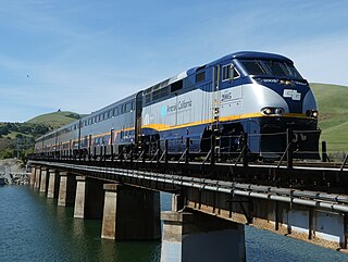
The Capitol Corridor is a 168-mile (270 km) passenger train route in Northern California operated by Amtrak between San Jose, in the Bay Area, and Auburn, in the Sacramento Valley. The route is named after the two points most trains operate between, San Jose and Sacramento. The route runs roughly parallel to I-880 and I-80. Some limited trips run between Oakland and San Jose. A single daily round trip runs between San Jose and Auburn, in the foothills of the Sierra Nevada. Capitol Corridor trains started in 1991.

<span class="mw-page-title-main">Altamont Corridor Express</span> Commuter rail service in Northern California

The Altamont Corridor Express is a commuter rail service in California, connecting Stockton and San Jose during peak hours only. ACE is named for the Altamont Pass, through which it runs. Service is managed by the San Joaquin Regional Rail Commission, and operations are contracted to Herzog Transit Services. The 86-mile (138 km) route includes ten stops, with travel time about 2 hours and 12 minutes end-to-end. In 2023, the line had a ridership of 576,300, or about 2,700 per weekday as of the first quarter of 2024. ACE uses Bombardier BiLevel Coaches, MPI F40PH-3C locomotives, and Siemens Charger locomotives.

The Sacramento Regional Transit District, commonly referred to as SacRT, is the agency responsible for public transportation in the Sacramento, California area. It was established on April 1, 1973, as a result of the acquisition of the Sacramento Transit Authority. In addition to operating over 81 bus routes with connecting bus service in the Sacramento area covering 438 square miles (1,134.4 km2), SacRT also operates a large light rail system, which ranks currently as the thirteenth busiest light rail system in the United States. In 2023, the system had a ridership of 15,836,400, or about 54,500 per weekday as of the first quarter of 2024.

<span class="mw-page-title-main">Blue Line (VTA)</span> Light rail line in San Jose, California

The Blue Line is a light rail line in Santa Clara County, California, and part of the Santa Clara Valley Transportation Authority (VTA) light rail system. It serves 26 stations entirely in San Jose proper, traveling between Baypointe and Santa Teresa stations, stopping at San Jose International Airport, Downtown San Jose, San Jose State University, and the Children's Discovery Museum of San Jose along the way. The line connects to Caltrain at Tamien. The Blue Line is one of three lines in the VTA light rail system; the other two being the Green Line and the Orange Line.

<span class="mw-page-title-main">CapMetro Rail</span> Hybrid rail system in Austin, Texas

CapMetro Rail is a hybrid rail system that serves the Greater Austin area in Texas and is owned by CapMetro, Austin's primary public transportation provider. The Red Line is CapMetro's first and currently only rail line, and connects Downtown Austin with Austin's northwestern suburbs. The line operates on 32 miles (51 km) of existing freight tracks, and serves 10 stations. After a series of delays, CapMetro Rail was inaugurated in March 2010. CapMetro added Friday evening and Saturday afternoon and evening regularly scheduled service on March 23, 2012. In 2023, the line had a ridership of 485,400, or about 1,800 per weekday as of the first quarter of 2024.

<span class="mw-page-title-main">Sacramento Valley Station</span> Railway station in Sacramento, California, US

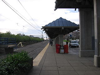
Sacramento Valley Station is an Amtrak railway station in the city of Sacramento, California, at 401 I Street on the corner of Fifth Street, built in 1926 on the site of China Slough. It is the thirteenth busiest Amtrak station in the country, and the second busiest in the Western United States. It is served by four different Amtrak train routes and connecting Amtrak Thruway motorcoaches. It is also the western terminus for the Gold Line of the Sacramento RT Light Rail system and the Route 30 bus serving California State University, Sacramento.

<span class="mw-page-title-main">Roseville Road station</span> Light rail station in North Highlands, California

Roseville Road station is an at-grade light rail station on the Blue Line of the Sacramento RT Light Rail system operated by the Sacramento Regional Transit District. The station is located in the median of Interstate 80 at its intersection with Roseville Road, after which the station is named, in the city of Sacramento, California, United States, close to the southern edge of the community of North Highlands.

<span class="mw-page-title-main">City College station (Sacramento)</span> Light rail station in Sacramento, California, US

City College station is an at-grade light rail station on the Blue Line of the Sacramento RT Light Rail system operated by the Sacramento Regional Transit District. The station is located in an exclusive right-of-way alongside the Union Pacific Railroad's Sacramento Subdivision and a small rail yard, on the campus of Sacramento City College, after which the station is named, in the city of Sacramento, California.

<span class="mw-page-title-main">Watt/I-80 station</span> Light rail station in North Highlands, California

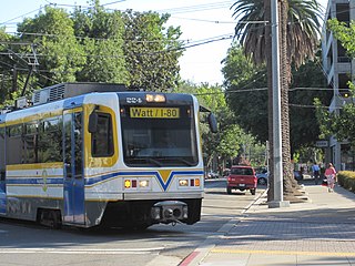
Watt/I-80 station is a below-grade light rail station on the Blue Line of the Sacramento RT Light Rail system operated by the Sacramento Regional Transit District. The station is located in the median of Interstate 80 at its intersection of Watt Avenue, after which the station is named, in the community of North Highlands, California, United States.

<span class="mw-page-title-main">7th & Capitol and 8th & Capitol stations</span> Sacramento Regional Transit District light rail stations

7th & Capitol and 8th & Capitol stations are a pair of Sacramento Regional Transit District light rail stations, served by all three RT light rail lines: Blue, Gold and Green. It is located in Downtown Sacramento at the intersection of Capitol Mall and 7th Street and 8th Street and within walking distance of the California State Capitol, Tower Bridge, Golden 1 Center, and Raley Field. Also, it is the westernmost station served by all three lines where transfers can be made between the Blue Line and the Gold and Green Lines.

<span class="mw-page-title-main">12th & I station</span>

12th & I station is an at-grade light rail station on the Blue Line of the Sacramento RT Light Rail system operated by the Sacramento Regional Transit District. The station is located alongside 12th Street at its intersection with I Street, after which the station is named, in the city of Sacramento, California.

<span class="mw-page-title-main">Blue Line (Sacramento RT)</span> Light rail line in Sacramento, California

The Blue Line is a light rail line in the Sacramento Regional Transit District (RT) system. It runs primarily north–south in Sacramento between Watt/I-80 and Cosumnes River College. Along the route, the Blue Line serves North Highlands, North Sacramento, Downtown and South Sacramento. Portions of the Blue Line run along the original initial alignment between Watt/I-80 and 16th Street stations.

<span class="mw-page-title-main">Gold Line (Sacramento RT)</span> Light rail line in the Sacramento, California area

The Gold Line is a light rail transit line in the Sacramento Regional Transit District (RT) light rail system. Operating between Sacramento Valley and Historic Folsom stations, the line runs primarily east-west in Sacramento, portions of unincorporated Sacramento County, Rancho Cordova, Gold River and Folsom. Segments of the Gold Line run along the system's original alignment between 16th Street and Butterfield stations, which opened for service in 1987. The line has run in its modern configuration since June 2005, with extensions completed since then to Folsom and the downtown Amtrak station.

<span class="mw-page-title-main">DART Light Rail</span> Light rail system in the Dallas-Fort Worth Metroplex

DART Light Rail is the light rail system serving the metropolitan area of Dallas, Texas and is owned and operated by Dallas Area Rapid Transit (DART). The DART Light Rail system opened June 14, 1996 and serves 65 stations and four lines, covering 93 miles (149.7 km): the Blue Line, the Red Line, the Green Line, and the Orange Line.

7th & Richards/Township 9 station is a side platformed Sacramento RT Light Rail station in Sacramento, California, United States. The station was opened on June 15, 2012, and is operated by the Sacramento Regional Transit District. It is currently the northern terminus of the Green Line and is the only RT light rail station exclusively served by the Green Line, which will ultimately provide service to the Sacramento International Airport upon future build-out. Greyhound Lines's Sacramento bus depot is near the station, at 420 Richards Boulevard.

<span class="mw-page-title-main">Metro (Minnesota)</span> Rapid transit network in the Minneapolis metropolitan area of the United States

Metro is a transit network in Minnesota serving the cities of Minneapolis and Saint Paul. It also provides service to some suburban areas. As of 2022, the system consists of two light rail lines and five bus rapid transit (BRT) lines all of which are operated by the local public transit company: Metro Transit. The five lines connect Downtown Minneapolis and St Paul with Bloomington, Minneapolis-St Paul International Airport, Roseville, Richfield, Burnsville and Brooklyn Center.

<span class="mw-page-title-main">Sacramento RT Light Rail</span> Light rail system in Sacramento, California

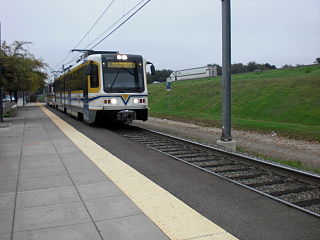
Sacramento RT Light Rail is a 42.9-mile (69.0 km) light rail system that serves the Sacramento, California area. It consists of three rail lines, 53 stations, and a fleet of 96 vehicles. It is operated by the Sacramento Regional Transit District (RT). With an average of 21,700 weekday daily boardings as of the first quarter of 2024, the RT light rail system is the fifteenth busiest in the United States.

<span class="mw-page-title-main">Transportation in the Sacramento metropolitan area</span> Complex multi-modal network moving people and goods in the region of Californias state capital

Transportation in the Sacramento metropolitan area consists of a variety of modes of travel in El Dorado County, Placer County, Sacramento County, and Yolo County, which are the four counties that comprise the Sacramento metropolitan area.

References

  1. RT Quarterly Ridership Report (PDF) (Report). Sacramento RT. June 2018. Retrieved December 12, 2018.
  2. 1 2 "Sacramento Green Line Open". Light Rail Transit Association. June 16, 2012. Archived from the original on March 7, 2016. Retrieved August 19, 2012.
  3. "RT Light Rail Schedules: 519 Green Line" (PDF). Sacramento Regional Transit. Retrieved August 19, 2012.
  4. "History of the Project". Sacramento RT. Archived from the original on August 21, 2015. Retrieved December 23, 2018.
  5. "Green Line to the River District". Sacramento RT. Archived from the original on September 27, 2015. Retrieved December 23, 2018.
  6. Shannon, Chris (June 15, 2012). "Light Rail Makes First Step Toward Natomas". The Natomas Buzz. Retrieved December 23, 2018.
  7. Bizjack, Tony (May 20, 2016). "Light-rail Green Line may shut in Sacramento to save money". Sacramento Bee. Retrieved August 22, 2016.
  8. "Roseville Transit Commuter Bus Services Guide" (PDF). Roseville Transit . April 1, 2020.
  9. McLawhorn, Jennifer (July 6, 2023). "SacRT Receives $35 Million for Improving Light Rail System". Railway Track & Structures . Retrieved September 4, 2023.
  10. "Green Line to the Airport". Green Line 2 Airport. Sacramento RT. Archived from the original on May 13, 2016. Retrieved December 14, 2018.
  11. "Schedule*". Green Line 2 Airport. Retrieved May 27, 2019.

Commons-logo.svg Media related to Green Line (Sacramento RT) at Wikimedia Commons

Template:Attached KML/Green Line (Sacramento RT)
KML is from Wikidata