
Colorado is a state in the Mountain West subregion of the Western United States. Colorado borders Wyoming to the north, Nebraska to the northeast, Kansas to the east, Oklahoma to the southeast, New Mexico to the south, Utah to the west, and meets Arizona to the southwest at the Four Corners. Colorado is noted for its landscape of mountains, forests, high plains, mesas, canyons, plateaus, rivers, and desert lands. Colorado is one of the Mountain States and is often considered to be part of the southwestern United States. The high plains of Colorado may be considered a part of the midwestern United States. It encompasses most of the Southern Rocky Mountains, as well as the northeastern portion of the Colorado Plateau and the western edge of the Great Plains. Colorado is the eighth most extensive and 21st most populous U.S. state. The United States Census Bureau estimated the population of Colorado at 5,877,610 as of July 1, 2023, a 1.80% increase since the 2020 United States census.

Cyrenaica or Kyrenaika, is the eastern region of Libya. Cyrenaica includes all of the eastern part of Libya between the 16th and 25th meridians east, including the Kufra District. The coastal region, also known as Pentapolis in antiquity, was part of the Roman province of Crete and Cyrenaica, later divided into Libya Pentapolis and Libya Sicca. During the Islamic period, the area came to be known as Barqa, after the city of Barca.

Larimer County is a county located in the U.S. state of Colorado. As of the 2020 census, the population was 359,066. The county seat and most populous city is Fort Collins. The county was named for William Larimer, Jr., the founder of Denver.

Jefferson County is a county located in the U.S. state of Colorado. As of the 2020 census, the population was 582,910, making it the fourth-most populous county in Colorado. The county seat is Golden, and the most populous city's Lakewood.
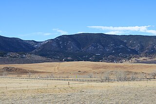
Perry Park is an unincorporated community and a census-designated place (CDP) located in Douglas County, Colorado, United States. The CDP is a part of the Denver–Aurora–Lakewood, CO Metropolitan Statistical Area. The population of the Perry Park CDP was 1,932 at the United States Census 2020. The Perry Park Metropolitan District and the Perry Park Water & Sanitation District provide services. The Larkspur post office serves the area.
Jebel Akhdar or Djebel Akhdar may be:

The Jebel Akhdar is a heavily forested, fertile upland area in northeastern Libya. It is located in the modern shabiyahs or districts of Derna, Jabal al Akhdar, and Marj.

The Taconic Mountains are a 150-mile-long sub-range of the Appalachian Mountains lying on the eastern border of New York State and adjacent New England. The range, which played a role in the history of geological science, is separated from the Berkshires and Green Mountains to the east by a series of valleys, principally those of the Housatonic River, Battenkill River and Otter Creek. The Taconics' highest point is Mount Equinox in Vermont at 3,840 feet (1,170 m); among many other summits are Dorset Mountain, Mount Greylock and Mount Everett.
The Appalachian National Scenic Trail spans 14 U.S. states over its roughly 2,200 miles (3,500 km): Georgia, North Carolina, Tennessee, Virginia, West Virginia, Maryland, Pennsylvania, New Jersey, New York, Connecticut, Massachusetts, Vermont, New Hampshire, and Maine. The southern end is at Springer Mountain, Georgia, and it follows the ridgeline of the Appalachian Mountains, crossing many of its highest peaks and running almost continuously through wilderness before reaching the northern end at Mount Katahdin, Maine.

The Mediterranean woodlands and forests is an ecoregion in the coastal plains, hills, and mountains bordering the Mediterranean Sea and Atlantic Ocean in North Africa. It has a Mediterranean climate, and is in the Mediterranean forests, woodlands, and scrub biome.

This is an alphabetical list of articles related to the U.S. State of Colorado.

The following is an alphabetical list of articles related to the U.S. state of Utah.
The following outline is provided as an overview of and topical guide to the U.S. state of Colorado:
Lakewood is the home rule municipality that is the most populous municipality in Jefferson County, Colorado, United States. The city population was 155,984 at the 2020 U.S. Census, making Lakewood the fifth most populous city in Colorado and the 167th most populous city in the United States. Lakewood is a suburb of Denver and is a principal city of the Denver–Aurora–Lakewood, CO Metropolitan Statistical Area and a major city of the Front Range Urban Corridor.
This is a bibliography of the U.S. State of Colorado.

The Front Range Urban Corridor is an oblong region of urban population located along the eastern face of the Southern Rocky Mountains, encompassing 18 counties in the US states of Colorado and Wyoming. The corridor derives its name from the Front Range, the mountain range that defines the western boundary of the corridor which serves as a gateway to the Rocky Mountains. The region comprises the northern portion of the Southern Rocky Mountain Front geographic area, which in turn comprises the southern portion of the Rocky Mountain Front geographic area of Canada and the United States. The Front Range Urban Corridor had a population of 5,055,344 at the 2020 Census, an increase of +16.65% since the 2010 Census.
The Blue Hills just west of Bremerton, Washington, also called the Bremerton Hills, Bald Hills, and Wildcat Hills, consist of Gold Mountain, Green Mountain, and several informally named hills. Reaching an elevation of 1761 feet, a thousand feet above the glacial till that fills the Puget Lowland, they form a prominent landmark visible around the region. They are formed of uplifted blocks of marine basalts, the steep-walled canyons between the various summits being the fissures between the blocks. In addition to Gold Mountain and Green Mountain are several other prominent peaks unofficially named according to their elevation :