
The South Platte River is one of the two principal tributaries of the Platte River. Flowing through the U.S. states of Colorado and Nebraska, it is itself a major river of the American Midwest and the American Southwest/Mountain West. Its drainage basin includes much of the eastern flank of the Rocky Mountains in Colorado, much of the populated region known as the Colorado Front Range and Eastern Plains, and a portion of southeastern Wyoming in the vicinity of the city of Cheyenne. It joins the North Platte River in western Nebraska to form the Platte, which then flows across Nebraska to the Missouri. The river serves as the principal source of water for eastern Colorado. In its valley along the foothills in Colorado, it has permitted agriculture in an area of the Colorado Piedmont and Great Plains that is otherwise arid.

The Blue River is a tributary of the Colorado River, approximately 65 miles (105 km) long, in the U.S. state of Colorado.

Grand Lake is Colorado's largest and deepest natural lake. It is located in the headwaters of the Colorado River in Grand County, Colorado. On its north shore is located the historic and eponymous town of Grand Lake. The lake was formed during the Pinedale glaciation, which occurred from 30000 BC to 10000 BC. The glacial terminal moraine created a natural dam. Natural tributaries to the lake are the North Inlet and East Inlet, both of which flow out of Rocky Mountain National Park, which surrounds the lake on three sides. Grand Lake is located 1 mile from the Park's western entrance. Grand Lake was named Spirit Lake by the Ute Tribe because they believed the lake's cold waters to be the dwelling place of departed souls.

Horsetooth Reservoir is a large reservoir in southern Larimer County, Colorado, in the foothills just west of the city of Fort Collins, Colorado. The reservoir runs north-south for approximately 6.5 miles (10 km) and is approximately one-half mile (1 km) wide. Its shape and orientation are the result of the fact that the main body of the reservoir is contained between several homoclinal ridges. A ridge composed of Dakota sandstone runs along the east side where gaps in the ridge are plugged by dams. On the west (uphill) side there are two prominent ridges topped by erosion-resistant sandstones of the Lyons and Ingleside formations. Gaps in these ridges have created a handful of bays and coves the largest of which is Inlet Bay, home to a marina and campgrounds.

The Colorado–Big Thompson Project is a federal water diversion project in Colorado designed to collect West Slope mountain water from the headwaters of the Colorado River and divert it to Colorado's Front Range and plains. In Colorado, approximately 80% of the state's precipitation falls on the West Slope, in the Rocky Mountains, while around 80% of the state's growing population lives along the eastern slope, between the cities of Fort Collins and Pueblo.

Flaming Gorge Dam is a concrete thin-arch dam on the Green River, a major tributary of the Colorado River, in northern Utah in the United States. Flaming Gorge Dam forms the Flaming Gorge Reservoir, which extends 91 miles (146 km) into southern Wyoming, submerging four distinct gorges of the Green River. The dam is a major component of the Colorado River Storage Project, which stores and distributes upper Colorado River Basin water.

Shadow Mountain Dam is a zoned earth-fill dam on the Colorado River in Grand County, Colorado. Constructed between 1944 and 1946, the Shadow Mountain Dam creates the Shadow Mountain Lake, with a structural height of 63 feet (19 m) and a drainage area of 187 square miles (480 km2). Shadow Mountain Lake is a holding reservoir for water pumped up from Lake Granby just to the south through the Granby Pumping Plant and Canal. Shadow Mountain Lake is connected by a short channel to the natural Grand Lake. The west portal of the Alva B. Adams Tunnel is located on Grand Lake. The Adams Tunnel diverts west slope water to the east slope of the Rocky Mountains for use in agriculture and to serve the populated areas of Colorado, including Denver.

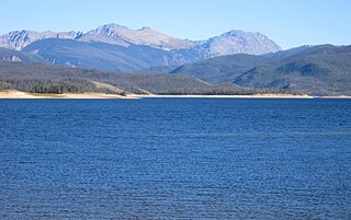
Granby Dam is an earthfill dam that dams the Colorado River 5.5 miles (8.9 km) northeast of Granby, Colorado in Grand County, Colorado. This 298-foot (91 m)-tall dam was constructed between 1941 and 1950 and has a drainage area of 311 square miles (810 km2). The Granby Dam's reservoir is known as Lake Granby, the largest reservoir component of the Colorado-Big Thompson Project. Lake Granby stores Colorado River water that is diverted under the Continental Divide for agriculture and municipal use within north-eastern Colorado including the cities of Boulder, Fort Collins, Loveland, and Greeley. In addition to the waters of the Colorado, water from Willow Creek just below the dam is pumped up 175 feet (53 m) to Lake Granby. Water from Lake Granby is pumped 125 feet (38 m) higher by the Granby Pumping Plant to the Granby Pump Canal, which extents 1.8 miles (2.9 km) to Shadow Mountain Lake, from which water is diverted through the Alva B. Adams Tunnel to the East Slope.
Strawberry Reservoir is a large reservoir in the U.S. state of Utah, located on the Strawberry River. It is Utah's most popular fishery, receiving over 1.5 million angling hours annually and is part of the Blue Ribbon Fisheries program. Game fish in the reservoir include sterilized rainbow trout, bear lake cutthroat trout, kokanee salmon and crayfish. It is located 23 miles (37 km) southeast of Heber, Utah on U.S. Route 40. The reservoir is situated in Strawberry Valley. This valley is normally part of the Colorado River drainage. The dam was constructed to divert water into Utah Valley.

Navajo Dam is a dam on the San Juan River, a tributary of the Colorado River, in northwestern New Mexico in the United States. The 402-foot (123 m) high earthen dam is situated in the foothills of the San Juan Mountains about 44 miles (71 km) upstream and east of Farmington, New Mexico. It was built by the U.S. Bureau of Reclamation (Reclamation) in the 1960s to provide flood control, irrigation, domestic and industrial water supply, and storage for droughts. A small hydroelectric power plant was added in the 1980s.

The Fryingpan–Arkansas Project, or "Fry-Ark," is a water diversion, storage and delivery project serving southeastern Colorado. The multi-purpose project was authorized in 1962 by President Kennedy to serve municipal, industrial, and hydroelectric power generation, and to enhance recreation, fish and wildlife interests. Construction began in 1964 and was completed in 1981. The project includes five dams and reservoirs, one federal hydroelectric power plant, and 22 tunnels and conduits totaling 87 miles (140 km) in length. The Bureau of Reclamation, under the Department of the Interior built and manages the project.

Yellowtail Dam is a dam across the Bighorn River in south central Montana in the United States. The mid-1960s era concrete arch dam serves to regulate the flow of the Bighorn for irrigation purposes and to generate hydroelectric power. The dam and its reservoir, Bighorn Lake, are owned by the U.S. Bureau of Reclamation.
Lake Granby is the third largest body of water in Colorado.
Antero Reservoir is a reservoir in the US state of Colorado. It was created by the first dam placed on the South Platte River in Park County, central Colorado. It is owned by Denver Water and supplies drinking water to the greater Denver metro region almost 140 miles (230 km) away.
The Alva B. Adams Tunnel is the principal component of the largest transmountain water project in Colorado, the Colorado-Big Thompson Project (C-BT). The tunnel transfers water from the western slope of the Colorado River drainage to the eastern Front Range of Colorado. It is 13.1 miles (21.1 km) long, with a concrete lined diameter of 9.75 feet (2.97 m). The tunnel drops 109 feet (33 m) in elevation along its length and runs in a straight line under the Continental Divide from west to east, passing under Otis Peak in Rocky Mountain National Park. At its deepest point, the tunnel is about 3,800 feet (1,200 m) below the surface of the mountain peaks. Construction began on 15 June 1940, but was suspended as a result of World War II priorities, from the end of 1942 to August 1943. The tunnel was holed through on 31 March 1944, an event that was broadcast throughout the United States by NBC Radio. The tunnel was posthumously named for its chief advocate, US Senator Alva B. Adams.

Sugar Loaf Dam is a dam in Lake County of mid-Colorado, 4 miles (6.4 km) west of Leadville.

Carter Lake Dam is a dam in Larimer County, Colorado.

Willow Creek Dam is a dam in Grand County, Colorado.

Part of the Uncompahgre Project located on the western slope of central Colorado, the Taylor Park Dam was engineered by the Bureau of Reclamation. It is located on the Taylor River, a tributary of the Gunnison River, and the dam is used to create the Taylor Park Reservoir in Gunnison County, Colorado. The dam has National Inventory of Dams ID number CO00151.

The Northern Colorado Water Conservancy District — more commonly referred to as Northern Water — is a water utility for eight counties in northeastern Colorado. Northern Water works with the Colorado-Big Thompson Project to transfer water from the Colorado Western Slope over the Continental Divide for agricultural, industrial, and municipal water supply in northeastern Colorado. The District's offices are in Berthoud, Colorado.
