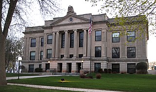
Sibley County is a county in the U.S. state of Minnesota. As of the 2010 United States Census, the population was 15,226. Its county seat is Gaylord. Sibley County is part of the Minneapolis-St. Paul-Bloomington, MN-WI Metropolitan Statistical Area.

Lyon County is a county in the U.S. state of Minnesota. As of the 2010 United States Census, the population was 25,857. Its county seat is Marshall.

Lincoln County is a county in the U.S. state of Minnesota. As of the 2010 United States Census, the population was 5,896. Its county seat is Ivanhoe.

Cottonwood County is a county in the U.S. state of Minnesota. As of the 2010 United States Census, the population was 11,687. Its county seat is Windom.

Pine River Township is a township in Cass County, Minnesota, United States. The population was 1,061 as of the 2000 census. This township took its name from the Pine River.

Powers Township is a township in Cass County, Minnesota, United States. The population was 918 at the 2000 census. Powers Township was named for Gorham Powers, a Minnesota politician who owned land there.

Mountain Lake is a city in Cottonwood County, Minnesota, United States. The population was 2,104 at the 2010 census.

Mountain Lake Township is a township located in Cottonwood County, Minnesota, United States. According to the 2010 census, the population was 384. The township was organized in 1871.

The Pigeon River forms part of the Canada–United States border between the state of Minnesota and the province of Ontario, west of Lake Superior. In pre-industrial times the river was a waterway of great importance for transportation and the fur trade.

Eagle Mountain is the highest natural point in Minnesota, United States, at 2,301 feet (701 m). It is in northern Cook County, in the Boundary Waters Canoe Area Wilderness and Superior National Forest in the Misquah Hills, northwest of Grand Marais. It is a Minnesota State Historic Site.

The Arrowhead Region is located in the northeastern part of the U.S. state of Minnesota, so called because of its pointed shape. The predominantly rural region encompasses 10,635.26 square miles (27,545.2 km2) of land area and includes Carlton, Cook, Lake and Saint Louis counties. Its population at the 2000 census was 248,425 residents. Aitkin, Itasca, and Koochiching counties are also sometimes considered as part of the region. This would increase the land area to 18,221.97 square miles (47,194.7 km2) and the population to 322,073 residents.

Minnesota is the northernmost state outside Alaska; its isolated Northwest Angle in Lake of the Woods is the only part of the 48 contiguous states lying north of the 49th parallel. Minnesota is in the U.S. region known as the Upper Midwest. The state shares a Lake Superior water border with Michigan and Wisconsin on the northeast; the remainder of the eastern border is with Wisconsin. Iowa is to the south, North Dakota and South Dakota are west, and the Canadian provinces of Ontario and Manitoba are north. With 87,014 square miles (225,370 km2), or approximately 2.26 % of the United States, Minnesota is the 12th largest state.

The Sawtooth Mountains are a range of hills or small mountains on the North Shore of Lake Superior in the U.S. state of Minnesota, extending about 30 miles (50 km) from Carlton Peak near Tofte on the west, to Grand Marais on the east.
Greenwood Mountain is the name of several mountain summits in the United States.

White Bear Lake is a lake in northeastern Ramsey County and western Washington County in the U.S. state of Minnesota, in the northeast part of the Minneapolis-St. Paul metropolitan area. The city of White Bear Lake takes its name from the lake.

Green Lakes Mountain (10,240 feet is located in the Teton Range in the U.S. state of Wyoming. The peak is on the border of Grand Teton National Park and the Jedediah Smith Wilderness of Caribou-Targhee National Forest. Green Lakes Mountain is at the head of Moran Canyon and 1 mile SSW of Dry Ridge Mountain.
Green Lake is a lake in Kandiyohi County, Minnesota. The lake has a surface area of 5,560.65 acres (22.5032 km2).

Green Lake is a lake in Isanti County, in the U.S. state of Minnesota.

Wall Lake is an unincorporated community in Otter Tail County, in the U.S. state of Minnesota.


